111582213976
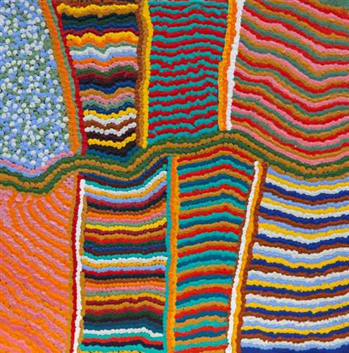
Karlamilyi River flows through the claypan and tuwa (sandhills)
“That’s all the tuwa (sandhill) see. Karlamilyi River in the middle. That’s my Ngurra. My country. I’ve been there lot of time. There’s the claypans see. Running through the tuwa.”
– Charleston Miller
Karlamilyi (Rudall River region) and its surrounds are Warnman Country, located in the very heart of the Martu homelands. The region is situated southwest of the Great Sandy Desert and northeast of the Little Sandy Desert. Spanning through the region is the epic Karlamilyi River, which runs north into Nyayartakujarra (Ngayarta Kujarra, Lake Dora), a large salt lake. The Broadhurst and Fingoon Ranges extend diagonally across the river’s path. The landscape is striking for its abundance of gorges and valleys carved by ice age glaciers, rugged cliffs, red tali (sand dunes), grasslands, sandstone and quartz rocky outcrops, and salt lakes.
Across the whole region are hundreds of water sources; including waterholes, creeks, soaks, lakes, pools and rockholes. Lining the rivers are coolabah, walyji (river gum), yulbah (bats wing coral tree), and several species of acacia and hakea. Jalkuran (paperbark), kurrulyu/ mijarrpa (bloodwood) and jawirli (quandong) are found in the region’s valleys, and wikirrpa (desert oaks) and grasses in the sandplains. The area is abundant with bird species, jila (snakes), maruntu (goannas), red kangaroos and warlpaju (rock wallabies). The region is also home to remote aboriginal communities Punmu and Parnngurr.
According to two of the central Martu Jukurrpa (Dreaming) narratives, the Karlamilyi River and its surrounds were created by the ancestral beings Jila Kujarra (Two Snakes) and the Wati Kujarra (Two Goanna Men) as they travelled across the lands.


