111582001337


Kaalpa (Kalypa, Canning Stock Route Well 23)

“Kaalpa (Kalypa, Canning Stock Route Well 23) is my grandfather’s Country. There’s a waterhole there, Kaalpa waterhole. It’s my two pops’ Country. They been walking around, hunting around Kaalpa. You can see a yapu (rock), warla (lake), claypans, karru (creek) and tuwa (sandhills) there. It’s on the [Canning] Stock Route, it’s Well 23.  

In pujiman (traditional, desert dwelling) days, pujimanpa (desert born people) walking around all this Country. My pops told me about that place, a big flat area, parlkarra (flat country) good for hunting parnajarrpa (goanna), lunki (witchetty grub), lungkurta (blue tongue lizard), wamurla (bush tomato), jinyjiwirrilyi (wild gooseberry). Kaalpa is a busy place for emus getting a drink. 

I went [to Kaalpa] for the first time [in 2018] on a Martumili KJ (Kanyirninpa Jukurrpa) trip. I went hunting there, got a parnajarrpa. When I went there, I was pukurlpa (happy). It made you open up your spirit, it feels like home.”

 – Corban Clause Williams

Kaalpa is a permanent water source located northeast of Kumpupirntily (Kumpupintily, Lake Disappointment). This site is a place of great cultural significance, and is also known for good hunting. Adjacent to the waterhole is a hill of the same name. The landscape around Kaalpa is parlkarra, bordered by tali (sandhills) stretching as far as Windy Corner, northeast and towards the border of Western Australia and the Northern Territory. The large and dangerous Jukurrpa (Dreamtime) mosquito and fly beings partially created the landforms in this area and continue to live underground here.

Kaalpa also features in the Minyipuru (Jakulyukulyu, Seven Sisters) Jukurrpa, a central creation narrative for Martu, Ngaanyatjarra, Pitjantjatjara and Yankunytjatjara people that is associated with the seasonal Pleiades star constellation. At Kaalpa the Minyipuru met a group of men; it was the first time either group had seen members of the opposite sex. The men tried to grab the women, but the Minyipuru chased them, hitting them with their digging sticks leaving them lying there as they continued travelling east.

Minyipuru is Relayed in song, dance, stories and paintings, Minyipuru serves as a creation narrative, a source of information relating to the physical properties of the land, and an embodiment of Aboriginal cultural laws. Beginning in Roebourne on the west coast of Western Australia, the story morphs in its movement eastward across the land, following the women as they walk, dance, and even fly from waterhole to waterhole. As they travel the women camp, sing, wash, dance and gather food, leaving markers in the landscape and creating landforms that remain to this day, such as groupings of rocks and trees, grinding stones and seeds. During the entirety of their journey the women are pursued by a lustful old man, Yurla, although interactions with other animals, groups of men, and spirit beings are also chronicled in the narrative.

The intersection of the Canning Stock Route with Kaalpa also made this a site of early contact with Europeans for many Martu then living a pujiman life in the desert. Following the route’s construction, Martu encountered Europeans and other Martu working as cattle drovers as they would travel up and down the Stock Route from water source to water source. Increasingly, pujimanpa followed the route to newly established ration depots, mission and pastoral stations. They were drawn to the route in search of food, by a sense of curiosity, or by loneliness. By the late 1950s and early 1960s, most of the desert family groups had left the desert. Eventually, these factors combined with an extreme and prolonged drought in the 1960s to prompt the few remaining pujimanpa to move in from the desert.

111582001335


Rabbit Proof Fence

“I painted the Rabbit Proof Fence and the tracks of the emus. They can’t get through because the gate is closed. If they can’t get through they go back to the sand hills. We still see that Rabbit Proof Fence out there, it goes to Jilakurru then to Jigalong, long one, and it’s a bit broken now. The three girls passed through Jilakurru going to Jigalong. Everybody likes that story in Jigalong, I like painting that story.” 

– Judith Anya Samson

In 1931 sisters Molly Craig, Daisy Kadibil and Gracie Fields were taken from their families, like many other Aboriginal children at that time, and transported to Moore River Native Settlement, north of Perth. They were taken away in the belief that part-Aboriginal children should be trained as domestic servants. 

The three girls escaped the next day and, incredibly, walked 1600 kilometres home to Jigalong using the Rabbit-Proof Fence to navigate. The Rabbit Proof Fence remains the world’s longest fence, and was built in the early 1900s to separate rabbits from pasture. For nine weeks, the girls followed its length in order to be reunited with their family. They crossed a flooded river, sand dunes, heathlands, wheatbelts and plains, claypans and salt lakes. They slept in dug-out rabbit burrows, and caught and cooked rabbits, along with other plant based bush tucker. For the duration of their journey they were pursued by policeman and an Aboriginal police tracker.

The girls’ story has been immortalised in the novel “Follow the Rabbit-Proof Fence” by Doris Pilkington (Nugi Garimara, 1996), and was adapted into the film “Rabbit Proof Fence” (2002). This story retains special significance for the Martu, and in particular those inhabitants of Jigalong Aboriginal community. The three girls were Martu, and their children and grandchildren continue to live in the Martu homelands today. Judith grew up with her grandparents in Jigalong. 

111582001333


Kunawarritji Rockholes

“These are the rockholes around Kunawarritji (Canning Stock Route Well 33). My mum [Jugarda Dulcie Gibbs] painted the same. It’s my father’s Country; he was born at Well 33. I’m painting Well 35, Kinyu, all the way to Well 38, Wajaparni. This is a big place for us. It’s important. I went on a trip with Kanyirninpa Jukurrpa [ranger group] last year [2018] to visit all these rockholes.”

– Pauline Williams 

Kunawarritji is an important site in the Great Sandy Desert where multiple stories and histories intersect. The area forms part of Pauline’s ngurra (home Country, camp) through her family. Originally a spring water and major Martu pujiman (traditional, desert dwelling) camping site, at the turn of the 20th century Kunawarritji was converted into a well along the Canning Stock Route. Each year throughout the 1930-50s, the well became a site of contact between the drovers, their cattle, and desert families.

Long before colonial history entered this Country, however, other stories dominated the site. Primarily, Kunawarritji features in the Minyipuru (Jakulyukulyu, Seven Sisters) Jukurrpa (Dreaming). Minyipuru is a central Jukurrpa narrative for Martu, Ngaanyatjarra, Pitjantjatjara and Yankunytjatjara people that is associated with the seasonal Pleiades star constellation. Today, Kunawarritji is a site of return, a place where people came back to continue their life in the desert with the formation of Kunawarritji Aboriginal community in the early 1980s. The community’s cultural significance endures, with the population swelling up to 1000 during cultural business. 

As Pauline states in her account, this work depicts the waterholes and tali (sandhills) in the area surrounding Kunawarritji, typically represented with circular forms. During the pujiman period, knowledge of water sources was critical for survival, and today Martu Country is still defined in terms of the location and type of water. Each of the hundreds of claypans, rockholes, waterholes, soaks and springs found in the Martu desert homelands is known through real life experience and the recounting of Jukurrpa narratives by name, location, quality and seasonal availability.

Transfer of cultural knowledge through visual arts is an important way for Martu artists to keep their culture strong. Younger Martu artists like Pauline typically begin painting with their parents, grandparents and extended family, thus fostering an organic process of learning, not only about painting techniques, but also specific locations, family histories, traditional ways of life, bush tucker and  Jukurrpa. 

111582001331


Waru (Fire)

“This a waru (fire). Nyurnma (freshly burnt) country there, and a waru-waru (green shoots and young plants). After that you got manguu (mature spinifex, able to be burnt).”

– Ngamaru Bidu

This work depicts the practice of fire burning as it continues to be used today through the Martu homelands. Over thousands of years, as Martu travelled and hunted on foot they would burn tracts of land, using waru as a means to assist with hunting, to encourage regenerative growth, and to increase biodiversity. Whilst fire burning practices have modernised in recent times, with Martu burning areas close to Aboriginal communities and along roads, or else further afield using helicopters and 4WDs with Indigenous ranger group Karnyirninpa Jukurrpa (KJ), the same objectives are met as those during pujiman (traditional, desert dwelling) times.


Targeted waru is an important tool in animal tracking. Small burns are lit to clear vegetation, expose burrows, and to allow for access to walk and track readily in exposed sands. Fires are typically burnt during cooler weather in small, controlled areas, reducing the risk of unmanageable, spontaneous bush fires  whilst simultaneously providing diverse regenerating habitats. Remaining is a defined mosaic fire scar pattern in the land, across tali (sand dunes), linyji (clay pans), parulyukurru (spinifex country) and pila (sandy plains). This patterning is clearly visible in Ngamaru’s works, where she paints fire from an aerial perspective.  


The patchwork nature of regrowth is aligned with the Martu cycle of burning and regrowth and its five distinct phases. First is nyurnma, followed after the rains by waru-waru, when young, bright green plants start to grow. Nyukura occurs between one and three years after burning, when plants have matured and are fruiting and seeding. Manguu is four to six years post burning, when spinifex has matured to the point that it can be burned once again. Finally, kunarka signifies the time when spinifex and other plant species have become old growth, and pose a risk of destructive bushfires.

111582001330


Emu Tracks to Puntawarri

“Emu go to the springs to have a drink of water and then move on to the next one.”

– Judith Anya Samson

Puntawarri is an important cultural area, as well as the site of a now abandoned community, a waterhole, creek and lake. Puntawarri is located on the middle stretches of the Canning Stock Route and east of the Jigalong Aboriginal Community, where Judith grew up with her grandmother and senior Martumili Artist Dadda Samson. Both artists continue to live there today.

Puntawarri lies within Judith’s ngurra (home Country, camp) through her mother’s family, and as a young girl she frequently travelled and hunted with her family in this area, learning the stories for this Country. Depicted in this work are the tracks of a group of emus on their way to Puntawarri waterhole, searching for kapi (water). 

Karlaya (emu) were traditionally hunted during the pujiman (traditional, desert dwelling) era, and they continue to be a favoured bush tucker for Martu today. During the pujiman (traditional, desert dwelling) period, Martu would traverse very large distances annually in small family groups, moving seasonally from water source to water source, and hunting and gathering bush tucker as they went. Jina (tracks, footprints) are used by Martu people when tracking bush tucker. In the absence of an actual animal sighting, tracks act as an identifier that an animal was present, which can then be followed to the animal’s present location. Besides providing information on location, Martu are able to interpret from tracks the passage of time since the tracks were imprinted, as well as the corresponding animal species and its size.

The softer and more extensive the ground surface, the easier it is to locate and follow tracks, thus certain conditions are favoured for tracking. Tuulparra (spring) and yalijarra (hot time) are preferred over wantajarra (winter), when south easterly tradewinds blow strongly to obscure tracks. Tracks and burrows are also more readily visible in early growth lands, such as nyurnma (freshly burnt Country) and waru-waru (growth of new shoots and young plants). For this reason, fire burning is an important tool in animal tracking. Small burns are lit to clear vegetation, expose burrows, and to allow for access to walk and track readily in exposed sands, while simultaneously providing diverse regenerating habitats.

111582001326


Tuwa in Puntawarri

“I do tuwa (sandhill) in my own style because that’s our Country. That’s a sandhill, that’s the Dreaming- the Jukurrpa. That’s our culture.

They stay there and we go through the sandhills at Puntawarri in the car. We go first tuwa, then the second tuwa, looking for the waterholes. Go up, up, up- ‘nother tuwa, ‘nother tuwa.

Long time [ago] in Puntawarri, when I was a little girl [with] my Nana and Pop [Dadda Samson and Yanjimi Peter Rowlands] we went climbing up the sandhill. And when I went up my Nana and Pop were at the bottom under a tree and I came down running then rolling, rolling right down to the ground! But I was ok- he right!”

– Judith Anya Samson

Puntawarri is an important cultural area located on the middle stretches of the Canning Stock Route and east of the Jigalong Mission (now Jigalong Aboriginal community), where Anya grew up and continues to live with her grandmother and renowned Martumili Artist, Dadda Samson. Puntawarri is also the site of an abandoned community, a waterhole, creek and lake. Puntawarri’s close proximity to Jigalong Mission made it a popular site for Martu to visit during the ‘mission days’.

While growing up at Jigalong Mission in the 1960’s, Dadda would return to Puntawarri every weekend to hunt and camp. Dadda has been teaching Anya to paint for a number of years, sharing the knowledge and Jukurrpa (Dreaming) stories associated with her ngurra (home Country, camp). 

For many Martu, like Anya and her family, Jigalong Mission was the site where their pujiman (traditional, desert dwelling) lifestyle came to an end from the late 1940s as they transitioned to a life as stockmen and women working in cattle stations in the Pilbara region and beyond. In the wake of the extreme and prolonged drought of the 1960s, the last of the remaining pujimanpa (desert dwellers) were forced to move to missions like Jigalong, where a supply of food and water was assured. There, many Martu were reunited with family members that had already moved in from the desert.

The traditional lands of the Martu people encompass the Great Sandy Desert and Rudall River regions of Western Australia, an enormous tract dominated by distinctive red tali, or tuwa (sandhills). These sandhills present an unforgiving landscape; sparse vegetation covers a seemingly never ending expanse of dunes, and yet these lands and the location of resources within them was known intimately by its pujiman (traditional, desert dwelling) inhabitants.


111582001321


Gingiana

“Gingianna rockhole. A lot of water there, Kumarina way.”

– Miriam Atkins

Gingianna is a rockhole and claypan located in the East Pilbara, forming part of Miriam’s Country- her ‘ngurra’ (home Country, camp). People identify with their ngurra in terms of specific rights and responsibilities, and the possession of intimate knowledge of the physical and cultural properties of one’s Country. Painting ngurra, and in so doing sharing the Jukurrpa (Dreaming) stories and physical characteristics of that place, has today become an important means of cultural maintenance. Miriam’s ngurra encompasses her birthplace on Bulloo Downs Station, south east of Newman, and the Country that her family walked in the pujiman (traditional, desert-dwelling) era, from the southern end of the Canning Stock Route through to Kumpupirntily (Kumpupintily, Lake Disappointment)

Portrayed in this work are features of Miriam’s family’s ngurra, such as the striking salt lakes, dominant permanent red tali (sandhills), warta (trees, vegetation), and the individually named water sources they camped at. Rock holes, waterholes, soaks and springs were all extremely important sites for Martu people during the pujiman period.

The encyclopaedic knowledge of the location, quality and seasonal availability of the hundreds of water bodies found in one’s Country sustained Martu as they travelled across their Country, hunting and gathering, visiting family, and fulfilling ceremonial obligations. They would traverse very large distances annually, visiting specific areas in the dry and wet season depending on the availability of water and the corresponding cycles of plant and animal life on which hunting and gathering bush tucker was reliant. As they travelled and hunted they would also burn areas of Country, generating a greater diversity of plant and animal life.

111582001318


Punmu waterholes

“Punmu, I went there when I was a young girl, a teenager with my mother and father before my mother passed. Big mob of people was there. No building, just little cubby houses [bough shelters]. Long time I been there. 

These here are the waterholes around Punmu; Rawa spring- Rawa means ‘long time’, Tuu-tuu, Jila-jila, Wirlarra and Yilyara. That is my ngurra (home Country, camp). We grew up in Punmu around all these water holes. I still live here with my grandkids, [we share the] same stories for all these places.” 

 – Marianne Burton


 Punmu refers to a region and an Aboriginal community within its vicinity, located 670km North-East of Newman. Created during the return to Country movement of the 1980s, with the recognition of Martu land rights and native title, the community was named after a nearby Jukurrpa (Dreaming) story. As described by Marianne, Punmu is her ngurra; she grew up in this region with her parents. 

Punmu community sits on the edge of a large salt lake known as Nyayartakujarra, or Lake Dora. The lake runs south into Karlamilyi River (Rudall River). Surrounding Punmu are numerous fresh water soaks and the red tali (sandhills) typical of the area. The most frequently visited yinta (permanent springs) around Punmu include Wirlarra, Rawa, Yilyara, Jila-jila and Tuu-tuu.

The Country around Punmu features in several Jukurrpa stories. Of particular importance is the story of the Jila Kujarra (Two Snakes), one of the key Jukurrpa narratives for the Martu. Though the story belongs to Warnman people, it is shared across the Western Desert with several other language groups. The narrative centres on the travels of two snakes as they are pursued by the Niminjarra, spiritual ancestors of the Warnman people. 

 Before transforming themselves into snakes, the Jila Kujarra were young brothers. As snakes, they began travelling home to their mother, but were intercepted by the Niminjarra, who tracked the Jila Kujarra to Paji, east of Nyayartakujarra (Lake Dora). Though the Jila Kujarra eluded their pursuers here by escaping under the lake at Paji, they were soon after speared and injured by two Pukurti (initiates with bundled hair) at Nyayartakujarra, who returned with the Niminjarra to cook the snakes at the site of Kumpupirntily (Kumpupintily, Lake Disappointment). As the Niminjarra cut down the length of the Jila Kujarra, the snake’s bladders were pierced, causing an explosion of scalding hot urine in which the Niminjarra all perished and became black rocks at the site. The spirits of the Jila Kujarra returned to their mother at Nyayartakujarra, where the mother and her sons entered the ground below Nyayartakujarra and remain to this day.

111582001294


Untitled

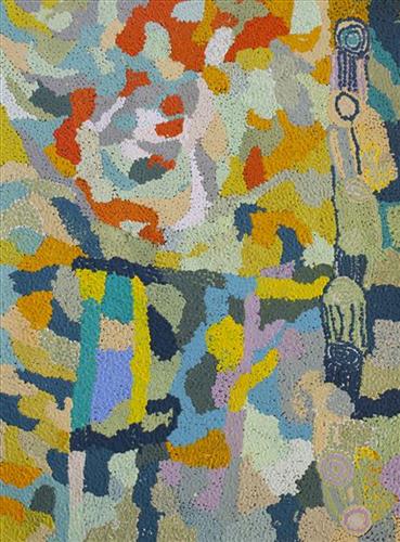
This is Dale’s Country- her ‘ngurra’ (home Country, camp). People identify with their ngurra in terms of specific rights and responsibilities, and the possession of intimate knowledge of the physical and cultural properties of one’s Country. Painting ngurra, and in so doing sharing the Jukurrpa (Dreaming) stories and physical characteristics of that place, has today become an important means of cultural maintenance. Dale’s ngurra encompasses her birthplace, Jigalong, and the Country that her family walked in the pujiman (traditional, desert-dwelling) era, including Puntawarri, Raarki (Canning Stock Route Well 27), Kularti, Kumpupirntily , Mirtikanya, (Kumpupintily, Lake Disappointment), and Mukurtu.

Portrayed in this work are features of Dale’s family’s ngurra, such as the striking salt lakes, dominant permanent red tali (sandhills), warta (trees, vegetation), and the individually named water sources they camped at. Rock holes, waterholes, soaks and springs were all extremely important sites for Martu people during the pujiman period, and are generally depicted with circular forms. 

The encyclopaedic knowledge of the location, quality and seasonal availability of the hundreds of water bodies found in one’s Country sustained Martu as they travelled across their Country, hunting and gathering, visiting family, and fulfilling ceremonial obligations. They would traverse very large distances annually, visiting specific areas in the dry and wet season depending on the availability of water and the corresponding cycles of plant and animal life on which hunting and gathering bush tucker was reliant. As they travelled and hunted they would also burn areas of Country, generating a greater diversity of plant and animal life.

111582001285


Untitled

“When Martu paint, it’s like a map. Martu draw story on the ground and on the canvas, and all the circle and line there are the hunting areas and different waters and tracks where people used to walk, and [some you] can’t cross, like boundaries. So nowadays you see a colourful painting and wonder what it is, but that’s how Martu tell story long ago. It’s not just a lovely painting, it’s a story and a songline and a history and everything that goes with it.” 

– Ngalangka Nola Taylor and Joshua Booth

This work portrays an area of Country that can be interpreted in multiple ways. Firstly, the image may be read as an aerial representation of a particular location known to the artist- either land that they or their family travelled, from the pujiman (traditional, desert dwelling) era to now. During the pujiman period, Martu would traverse very large distances annually in small family groups, moving seasonally from water source to water source, and hunting and gathering bush tucker as they went. At this time, one’s survival depended on their intimate knowledge of the location of resources; thus physical elements of Country, such as sources of kapi (water), tali (sandhills), different varieties of warta (trees, vegetation), ngarrini (camps), and jina (tracks) are typically recorded with the use of a use of a system of iconographic forms universally shared across the desert. 

An additional layer of meaning in the work relates to more intangible concepts; life cycles based around kalyu (rain, water) and waru (fire) are also often evident. A thousands of year old practice, fire burning continues to be carried out as both an aid for hunting and a means of land management today. As the Martu travelled and hunted they would burn tracts of land, ensuring plant and animal biodiversity and reducing the risk of unmanageable, spontaneous bush fires. The patchwork nature of regrowth is evident in many landscape works, with each of the five distinctive phases of fire burning visually described with respect to the cycle of burning and regrowth.  

Finally, metaphysical information relating to a location may also be recorded; Jukurrpa (Dreaming) narratives chronicle the creation of physical landmarks, and can be referenced through depictions of ceremonial sites, songlines, and markers left in the land. Very often, however, information relating to Jukurrpa is censored by omission, or alternatively painted over with dotted patterns.