111581442445


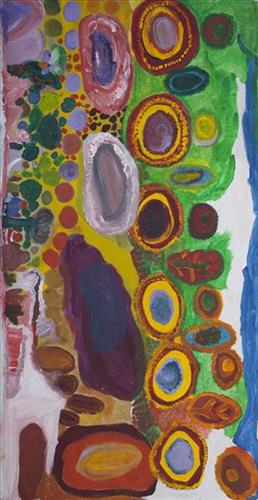
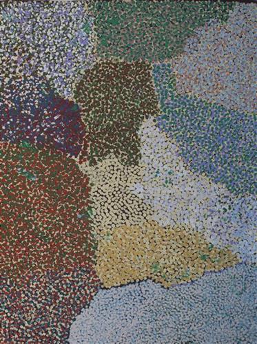
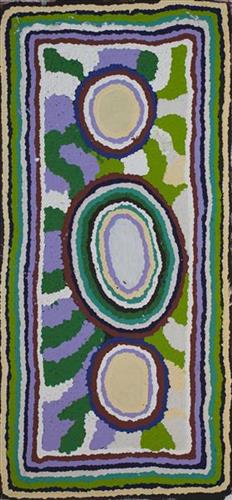
Well 35, My Country

This work portrays an area known intimately to the artist, painted here in exquisite detail from memory. During the pujiman (traditional, desert dwelling) era one’s survival depended on their intimate knowledge of the location of resources; thus physical elements of Country, such as sources of kapi (water), tali (sandhills), and different varieties of warta (trees, vegetation) were carefully observed and remembered. Today, this relationship with Country remains equally strong, despite the movement of Martu out of the desert and into remote Aboriginal Communities, towns and cities.

Also visible may be traces of life cycles based around kalyu (rain, water) and waru (fire). A thousands of year old practice, fire burning continues to be carried out as both an aid for hunting and a means of land management today. As the Martu travelled and hunted they would burn tracts of land, ensuring plant and animal biodiversity and reducing the risk of unmanageable, spontaneous bush fires. The patchwork nature of regrowth is visible in many landscape works, with each of the five distinctive phases of fire burning visually described with respect to the cycle of burning and regrowth.  

Finally, metaphysical information relating to a location may also be recorded; jukurrpa (dreaming) narratives chronicle the creation of physical landmarks, and can be referenced through depictions of ceremonial sites, songlines, and markers left in the land. 

111581444689


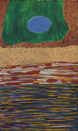
Punkulyi and Yulpu

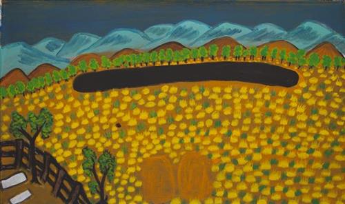
[Points to central oblong form] “That’s an old man with ngankurr (beard) and his brother living there at Punkulyi. They dreaming in Parnngurr area. They yapu (hill, rock) now. They been digging for water. They dug all the parna (dirt) out of the ground, digging and searching for water. They got tired and stayed there. They still there.”

Punkulyi forms part of the Mackay Range, near Parngurr community. In the dreamtime there were two men. The old man was named Ngankurr. When he lay down to rest his body formed the waterhole that exists there today.

111581446379


Untitled

This is Wurta Amy French’s Country- her ‘ngurra’ (home Country, camp). People identify with their ngurra in terms of specific rights and responsibilities, and the possession of intimate knowledge of the physical and cultural properties of one’s Country. Painting ngurra, and in so doing sharing the Jukurrpa (Dreaming) stories and physical characteristics of that place, has today become an important means of cultural maintenance. 

Wurta’s ngurra encompasses the Country that she and her family walked in the pujiman (traditional, desert-dwelling) era. At this time Wurta travelled nomadically with her own and other family groups. The Country they traversed encompassed an enormous tract of land, all around the Karlamily (Rudall River) region and through to Tiwa (Canning Stock Route Well 26) .

Wurta was born at Wantili (Warntili, Canning Stock Route Well 25). She grew up, walked and hunted primarily around water sources Pangkartal, Yalpalpa, Walirrlirri, Yanytikuji, Wartararra, Tintinmarran, Pimurlu, Raarki (Canning Stock Route Well 27), and Tiwa. Her family continued to live nomadically before eventually deciding to move to Jigalong Mission along with many other relatives following an extreme and prolonged drought in the 1960s. 

Portrayed in this work are features of Wurta’s ngurra, such as the hills, gorges and valleys, warta (trees, vegetation), and the individually named water sources she and her family camped at. Rock holes, waterholes, soaks and springs were all extremely important sites for Martu people during the pujiman period, and are generally depicted with circular forms. 

The encyclopaedic knowledge of the location, quality and seasonal availability of the hundreds of water bodies found in one’s Country sustained Martu as they travelled across their Country, hunting and gathering, visiting family, and fulfilling ceremonial obligations. They would traverse very large distances annually, visiting specific areas in the dry and wet season depending on the availability of water and the corresponding cycles of plant and animal life on which hunting and gathering bush tucker was reliant. As they travelled and hunted they would also burn areas of Country, generating a greater diversity of plant and animal life.

111981446690


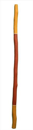
Didjeridu

Arnhem Land and the Top End of the Northern Territory is the traditional home of the didjeridu, a rhythmic wind instrument used by Aboriginal people of the region. Its use spread globally in part because the instrument was adopted by world music enthusiasts, and the profile of the instrument reached new heights through Aboriginal rock bands from Arnhem Land, such as Yothu Yindi. It’s an instrument that is now played around the world, in genres ranging from classical to hip hop.

The didjeridu has come to mean many different things to people who have a reason for playing it around the world. In Maningrida it remains primarily an instrument of song accompaniment used in public ceremony. The manner of playing provides an instant recognition to listeners of both language and regional stylistic affiliation. In the wake of the development of new non-Aboriginal ‘world’ styles of playing the instrument, Arnhem Land styles of playing take on new meaning as markers of the cultural and historical origins of the didjeridu.

All of the language groups of the Maningrida region have their own musical genres and song series in which the didjeridu is used as an instrument of accompaniment. Traditionally, it is primarily a secular instrument used in song genres that are performed for two main types of public ceremony: the music of diplomacy (exchange) ceremonies and of funerals and some mortuary rituals. The didjeridu is generally not used as a solo instrument and nor is it used in the most secret and sacred ceremonies still practiced in the western and central Arnhem Land region.

Aboriginal people living today in the rocky escarpment country of western Arnhem Land say that humans were first shown and taught to play the didjeridu by spirit beings who live among the dark caves and crevices of the stone country. These beings are known as mimih and are said to be tall and slender with necks so fragile they are easily snapped by the gentlest of breezes. Because of this, mimih live inside their own worlds within the rock. Mimih are credited with teaching Aboriginal people of the stone country about the foundations of stone country culture, including how to play the didjeridu. Many of the stone country language groups today describe their song and dance genres as mimih.

Researchers of Arnhem Land rock art have identified depictions of the didjeridu as belonging to the most recent phase of rock art, commencing around 1500 years ago.

Aboriginal names

Maningrida is a highly multilingual community and the linguistic diversity of western Arnhem Land is reflected in the various names used for the didjeridu. Here are the names for the instrument in the languages of the Maningrida region:

  • Ndjébbana (the language of the Kunibídji people) – ngalidjbinja
  • Kunwinjku, Kune, Kuninjku – mako [mago]
  • Rembarrnga – liddung, djalubbu
  • Burarra, Gun-nartpa – ngorla
  • Dangbon, Dalabon – morlo
  • Djinang, Wurlaki – wuyimbarl
  • Nakkara – ngunebobanja
  • Gurrgoni – mudburuja
  • Gundjeihmi (and also Kune) – morle

Process

The didjeridu-maker looks through bushland for a tree of the right species with the right diameter trunk. Most didjeridus in the Maningrida region are made from young trunks of the stringybark tree (Eucalyptus tetradonta) or the Darwin Woollybutt (Eucalyptus miniata).

The trunk needs to have been lived in and hollowed out by termites. To listen for hollowness, a tree with potential is stripped of a small patch of bark and the timber is tapped. The sound produced indicates the quality of the instrument the trunk will become. Having selected a good tree, the artist fells it and cleans out the hollow inside of the trunk, usually by ramming out any termite debris with a stick or pole. He strips all the bark off the outside, and smooths both ends. Traditionally, dark wax resin (cerumen or, in Kunwinjku and Rembarrnga languages, birdi) from native bees is applied to the mouthpiece. This substance sets hard but always becomes soft and pliable under pressure, enabling an airtight seal when playing.

Styles

In the Maningrida region, didjeridus are made to accompany songs in either of two styles: the bunggurl style of the language groups of eastern Arnhem Land (such as Bararra) or the kun-borrk style of language groups in the west of Arnhem Land (including Kunwinjku). People of central and south-western Arnhem Land whose country borders east and west (Rembarrnga and Kune), perform both styles.

Didjeridus of the region range in length from just under one metre to two metres. A less flared and longer didjeridu (1.5–2m) makes it easier to produce the characteristic hooted overblown tone that is used in bunggurl-style music. Longer didjeridus have a deeper tone than shorter didjeridus, and more resonance. To play them, you vibrate your lips at a lower frequency than you need to for a shorter didjeridu.

The decoration applied to the instrument can indicate its intended use. Rembarrnga artist Bob Burruwal often uses a design called bedjekbedjek. This is the same design used in body painting for the public diplomacy ceremonies of the Rembarrnga (and many other kun-borrk dance performances). Burruwal slaps wet white ochre over the surface of the instrument with his hands or with a bunch of leaves dipped in the ochre.
 

111581499754


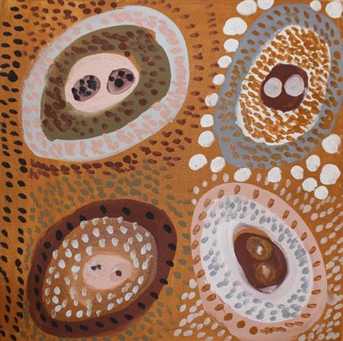
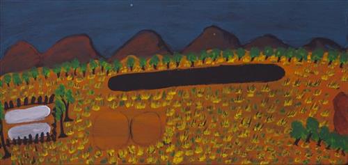
Untitled

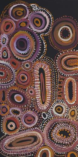
“When Martu paint, it’s like a map. Martu draw story on the ground and on the canvas, and all the circle and line there are the hunting areas and different waters and tracks where people used to walk, and [some you] can’t cross, like boundaries. So nowadays you see a colourful painting and wonder what it is, but that’s how Martu tell story long ago. It’s not just a lovely painting, it’s a story and a songline and a history and everything that goes with it.” 

– Ngalangka Nola Taylor and Joshua Booth

This work portrays an area of Country that can be interpreted in multiple ways. Firstly, the image may be read as an aerial representation of a particular location known to the artist- either land that they or their family travelled, from the pujiman (traditional, desert dwelling) era to now. During the pujiman period, Martu would traverse very large distances annually in small family groups, moving seasonally from water source to water source, and hunting and gathering bush tucker as they went. At this time, one’s survival depended on their intimate knowledge of the location of resources; thus physical elements of Country, such as sources of kapi (water), tali (sandhills), different varieties of warta (trees, vegetation), ngarrini (camps), and jina (tracks) are typically recorded with the use of a use of a system of iconographic forms universally shared across the desert. 

An additional layer of meaning in the work relates to more intangible concepts; life cycles based around kalyu (rain, water) and waru (fire) are also often evident. A thousands of year old practice, fire burning continues to be carried out as both an aid for hunting and a means of land management today. As the Martu travelled and hunted they would burn tracts of land, ensuring plant and animal biodiversity and reducing the risk of unmanageable, spontaneous bush fires. The patchwork nature of regrowth is evident in many landscape works, with each of the five distinctive phases of fire burning visually described with respect to the cycle of burning and regrowth.  

Finally, metaphysical information relating to a location may also be recorded; jukurrpa (dreaming) narratives chronicle the creation of physical landmarks, and can be referenced through depictions of ceremonial sites, songlines, and markers left in the land. Very often, however, information relating to jukurrpa is censored by omission, or alternatively painted over with dotted patterns.

221776385918


Aru

Mary has depicted the pretty rocks (Aru) and pools of her husband’s country in Berkeley River. Mary’s art details the rock formations along the Berkeley River as part of her ongoing connection to her husband and his country. Having lived and walked the river length with her husband and their children, Mary is acutely familiar with the geography and geology of place. Her swirling circle formation show the eddies of small rock pools and the rock markers along the river banks. Here she played as a girl amongst the ‘aru’- rocks and stones, fishing, swimming and telling stories. Occassional trees, palms and bush flowers add to her compositions of stones and rockholes signifiying a particular memory and place of importance. Her inspiration came from the stories told to her by her husband. “The stories told to me while we hunted for fish and turtle. He was a good old man, my husband.”

111581501251


Untitled

“When Martu paint, it’s like a map. Martu draw story on the ground and on the canvas, and all the circle and line there are the hunting areas and different waters and tracks where people used to walk, and [some you] can’t cross, like boundaries. So nowadays you see a colourful painting and wonder what it is, but that’s how Martu tell story long ago. It’s not just a lovely painting, it’s a story and a songline and a history and everything that goes with it.” 

– Ngalangka Nola Taylor and Joshua Booth

This work portrays an area of Country that can be interpreted in multiple ways. Firstly, the image may be read as an aerial representation of a particular location known to the artist- either land that they or their family travelled, from the pujiman (traditional, desert dwelling) era to now. During the pujiman period, Martu would traverse very large distances annually in small family groups, moving seasonally from water source to water source, and hunting and gathering bush tucker as they went. At this time, one’s survival depended on their intimate knowledge of the location of resources; thus physical elements of Country, such as sources of kapi (water), tali (sandhills), different varieties of warta (trees, vegetation), ngarrini (camps), and jina (tracks) are typically recorded with the use of a use of a system of iconographic forms universally shared across the desert. 

An additional layer of meaning in the work relates to more intangible concepts; life cycles based around kalyu (rain, water) and waru (fire) are also often evident. A thousands of year old practice, fire burning continues to be carried out as both an aid for hunting and a means of land management today. As the Martu travelled and hunted they would burn tracts of land, ensuring plant and animal biodiversity and reducing the risk of unmanageable, spontaneous bush fires. The patchwork nature of regrowth is evident in many landscape works, with each of the five distinctive phases of fire burning visually described with respect to the cycle of burning and regrowth.  

Finally, metaphysical information relating to a location may also be recorded; jukurrpa (dreaming) narratives chronicle the creation of physical landmarks, and can be referenced through depictions of ceremonial sites, songlines, and markers left in the land. Very often, however, information relating to jukurrpa is censored by omission, or alternatively painted over with dotted patterns.

111581501207


Ngurra Yalta

Yalta is a waterhole located between the Great Sandy Desert’s Percival Lakes region and Kunawarritji Aboriginal community. This site was visited by the Ngayurnangalku (cannibals) during the Jukurrpa (Dreaming). These fearsome ancestral cannibal beings said to resemble people in their appearance, except for their fangs and long curved knife like fingernails they use to catch and hold their human victims. The Ngayurnangalku continue to live beneath the crust of Kumpupirntily (Kumpupintily, Lake Disappointment), south east of Yalta.

Yalta lies within Mantyil’s ngurra (home Country, camp) through her father and grandfather, and was part of the area which she knew intimately and travelled extensively with her family in her youth. The Western Desert term ‘ngurra’ is hugely versatile in application. Broadly denoting birthplace and belonging, ngurra can refer to a body of water, a camp site, a large area of Country, or even a modern house. People identify with their ngurra in terms of specific rights and responsibilities, and the possession of intimate knowledge of the physical and cultural properties of one’s Country. This knowledge is traditionally passed intergenerationally through family connections. Painting ngurra, and in so doing sharing the Jukurrpa stories and physical characteristics of that place, has today become an important means of cultural maintenance. Physical maintenance of one’s ngurra, like cultural maintenance, ensures a site’s wellbeing, and is a responsibility of the people belonging to that area.

111581504014


Pitu (Separation Well)

“Pitu, soak, big one. Water there all the time. Pitu, the place for our whole family. [As a young girl] I walked around and went east back to my dad’s area, to Pitu and Kulilu, Nakaly and Kunapila. Then I was a teenager. My Country is Pitu and Nakaly, that’s my Country.

This man here, he came through here in the Dreamtime, walking right up through here and then he flew. Other one, a man and a woman, coming behind him, following him right up through here and then finish, I don’t know where they’ve gone. There is one more woman, going across here. Those three people walked through this Country and disappeared when they flew somewhere. They went forever. That was in the Dreamtime when they were walking around.”

 – Ngamaru Bidu, as translated by Ngalangka Nola Taylor

Pitu (Separation Well) is an important cultural site and large soak located yulparirra (south) of Wuranu (Canning Stock Route Well 29) and Kulilu rockhole and soak. As a site where fresh water was available all year, Pitu was an important camp and a meeting place for Kartujarra and Manyjilyjarra people during the pujiman (traditional, desert dwelling) era. At this time, knowledge of water sources was critical for survival, and today Martu Country is still defined in terms of the location and type of water. Each of the hundreds of claypans, rockholes, waterholes, soaks and springs found in the Martu desert homelands is known by name, location, quality and seasonal availability through real life experience and the recounting of Jukurrpa (Dreaming) narratives. 

Pitu lies within Ngamaru’s ngurra (home Country, camp), the area which she knew intimately and travelled extensively with her family in her youth. Ngamaru’s family name, ‘Bidu’, derives from this place name. In her account of the area, Ngamaru relates a Jukurrpa narrative that occurred in and around Pitu. The term Jukurrpa is often translated in English as the ‘Dreaming’, or ‘Dreamtime’. It refers generally to the period in which the world was created by ancestral beings, who assumed both human and nonhuman forms. These beings shaped what had been a formless landscape; creating waters, plants, animals, and people. At the same time they provided cultural protocols for the people they created, as well as rules for interacting with the natural environment. At their journey’s end, the ancestral beings transformed themselves into important waters, hills, rocks, and even constellations.