111582078235


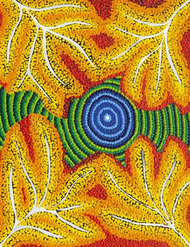
Wama (nectar)

Wama (nectar) refers to the delicious, sweet nectar gathered from several different plant species including yumpal (Corkwood Hakea), jalpinpa (Flame Grevillea) and Desert Heath Myrtle. Amongst the food groups, nectars are highly sought after by Martu, especially jalpinpa. Wama is most abundant in the cooler seasons tuulpara (spring) and wantajarra (cool season), and especially so following abundant rains. The locations of established fields of wama producing plants are well known to the Martu, and become highly frequented during harvest periods.

During the pujiman (traditional, desert dwelling) period, Martu would traverse very large distances annually in small family groups, moving seasonally from water source to water source, and hunting and gathering bush tucker as they went. Whilst desert life has moved away from mobile hunter-gatherer subsistence throughout the course of the twentieth century, bush tucker continues to be a significant component of the modern Martu diet. Hunting and gathering bush tucker remains equally valuable as an important cultural practice that is passed on intergenerationally. Though hunting and gathering implements have been modernised, methods of harvesting, tracking and the use of fire burning to drive animals from their retreats are still commonly practiced today.

111582078234


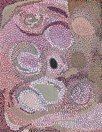
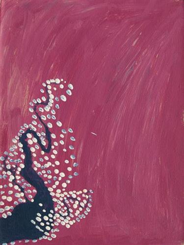
Yalta

“This is my grandmother’s and mother’s Country, Yalta. It’s very close to Kunawarritji side. I’ve never been there. That was where my mother was born during the pujiman (traditional, desert dwelling) times. All the tali (sandhills) around. I want to go there one day, to see that Country, I might go there one day” 


  • Marianne Burton

Yalta is a waterhole located between the Great Sandy Desert’s Percival Lakes region and Kunawarritji Aboriginal community. This site was visited by the Ngayurnangalku (cannibals) during the Jukurrpa (Dreaming). These fearsome ancestral cannibal beings said to resemble people in their appearance, except for their fangs and long curved knife like fingernails they use to catch and hold their human victims. The Ngayurnangalku continue to live beneath the crust of Kumpupirntily (Kumpupintily, Lake Disappointment), south east of Yalta.  

Yalta lies within Marianne’s ngurra (home Country, camp) through her grandmother and mother. As stated by Marianne here, the site is especially significant to her as it was here that her mother was born. The Western Desert term ‘ngurra’ is hugely versatile in application. Broadly denoting birthplace and belonging, ngurra can refer to a body of water, a camp site, a large area of Country, or even a modern house. People identify with their ngurra in terms of specific rights and responsibilities, and the possession of intimate knowledge of the physical and cultural properties of one’s Country. This knowledge is traditionally passed intergenerationally through family connections. Painting ngurra, and in so doing sharing the Jukurrpa stories and physical characteristics of that place, has today become an important means of cultural maintenance. Physical maintenance of one’s ngurra, like cultural maintenance, ensures a site’s wellbeing, and is a responsibility of the people belonging to that area.

111582078233


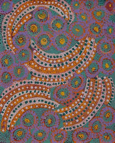
Untitled

This is Yunkurra’s Country- his ‘ngurra’ (home Country, camp). People identify with their ngurra in terms of specific rights and responsibilities, and the possession of intimate knowledge of the physical and cultural properties of one’s Country. Painting ngurra, and in so doing sharing the Jukurrpa (Dreaming) stories and physical characteristics of that place, has today become an important means of cultural maintenance. 

Yunkurra’s ngurra encompasses his birthplace, Palatji (Palarji, Weld Springs, Canning Stock Route Well 9), and the Country that he and his family walked in the pujiman (traditional, desert-dwelling) era. Yunkurra grew up, walked and hunted primarily around the areas surrounding Kumpupirntily (Lake Disappointment), Kupayura (Savory Creek) and Jilukurru (Killagurra Springs, Canning Stock Route Well 17). Eventually, as a ‘young fella’ he, like most other Martu at the time, began working on pastoral stations around the Pilbara, ‘mustering bullock, sheep too.’ In later life Yunkurra relocated to Jigalong Aboriginal community, closer to his home Country. 

Portrayed in this work are features of Yunkurra’s ngurra, such as the striking salt lakes, dominant permanent red tali (sandhills), warta (trees, vegetation), and the individually named water sources he and his family camped at. Rock holes, waterholes, soaks and springs were all extremely important sites for Martu people during the pujiman period, and are generally depicted with circular forms. 

The encyclopaedic knowledge of the location, quality and seasonal availability of the hundreds of water bodies found in one’s Country sustained Martu as they travelled across their Country, hunting and gathering, visiting family, and fulfilling ceremonial obligations. They would traverse very large distances annually, visiting specific areas in the dry and wet season depending on the availability of water and the corresponding cycles of plant and animal life on which hunting and gathering bush tucker was reliant. As they travelled and hunted they would also burn areas of Country, generating a greater diversity of plant and animal life.

111582079022


Yirriya

“I paint my dad’s country Yirriya.  It’s got running water coming out of the ground into a big dam, surrounded by lots of trees.  It’s really green.  It’s on Rawlinson Ranges 50-60km from Warakurna.  Nearby is Circus Waters where my dad was born we’d go swimming there, Lake Christopher is nearby too.  All part of his country.  We would go hunting, turkey, emu, kangaroo, look for bardi/lungi (witchetty grub), honey ants, yellow berries.  It’s an outstation we call it home.  We grew up in that place.  Family from Warakurna, Docker River, Wingelina, Warnan would come and stay.  Good memories of that place.”

– Roxanne Newberry


Warakurna is a large Aboriginal community, located in the Goldfields-Esperance region of Western Australia, within the Shire of Ngaanyatjarraku it lies near the foot of the spectacular Rawlinson Range, 300 kilometres west of Uluru (Ayers Rock) near the meeting of the borders of Western Australia, South Australia and the Northern Territory. Ngaanyatjarra people have strong ties with neighbouring Western Desert groups, including Martu.

This work portrays an area of Country that can be interpreted in multiple ways. Firstly, the image may be read as an aerial representation of a particular location known to the artist- either land that they or their family travelled, from the pujiman (traditional, desert dwelling) era to now. During the pujiman period, Martu would traverse very large distances annually in small family groups, moving seasonally from water source to water source, and hunting and gathering bush tucker as they went. At this time, one’s survival depended on their intimate knowledge of the location of resources; thus physical elements of Country, such as sources of kapi (water), tali (sandhills), different varieties of warta (trees, vegetation), ngarrini (camps), and jina (tracks) are typically recorded with the use of a system of iconographic forms universally shared across the desert. 

An additional layer of meaning in the work relates to more intangible concepts; life cycles based around kalyu (rain, water) and waru (fire) are also often evident. A thousands of year old practice, fire burning continues to be carried out as both an aid for hunting and a means of land management today. As the Martu travelled and hunted they would burn tracts of land, ensuring plant and animal biodiversity and reducing the risk of unmanageable, spontaneous bush fires. The patchwork nature of regrowth is evident in many landscape works, with each of the five distinctive phases of fire burning visually described with respect to the cycle of burning and regrowth.  

Finally, metaphysical information relating to a location may also be recorded; Jukurrpa (Dreaming) narratives chronicle the creation of physical landmarks, and can be referenced through depictions of ceremonial sites, songlines, and markers left in the land. Very often, however, information relating to Jukurrpa is censored by omission, or alternatively painted over with dotted patterns.