111581650869


Parnngurr School

“In 1984 my nyupa (partner) Mr Williams and I moved our family from Jigalong to Parnngurr community. Our five children were all young back then. People wanted to mine at Parnngurr. There was lots of drilling going on.

There wasn’t much out there when Parnngurr community formed, just a bow shelter, a windmill and a 44 gallon drum.

We worked hard for there to be a good school in community. If there was going to be teachers at the school they needed somewhere to live. The first teacher to work at Parnngurr school lived in a caravan. I worked alongside her at the school.

The school is different now. It’s grown a lot. There are more buildings, and a new basketball court was recently built. A lot of people have worked hard to make the school a good place.”

 – Noreena Kadibil


Noreena Kadibil is a Martu artist currently living in Parnngurr community. Noreena is known for her historical paintings, sharing significant family histories through her work. Noreena regularly paints the Parnngurr School. Community schools are vital components of remote communities, enabling young families to continue living in community, providing employment and an opportunity for two-way learning.

Noreena has close ties to Parnngurr School. She was employed as a Martu teacher when the school was first formed, and many of her children and grandchildren have either attended or been employed by the school. Depicting her grandchildren alongside Parnngurr School illustrates the continuing importance of the school within Noreena’s family and the wider community.


111981659911


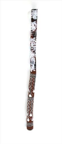
Mako (didjeridu)

Arnhem Land and the Top End of the Northern Territory is the traditional home of the didjeridu, a rhythmic wind instrument used by Aboriginal people of the region. Its use spread globally in part because the instrument was adopted by world music enthusiasts, and the profile of the instrument reached new heights through Aboriginal rock bands from Arnhem Land, such as Yothu Yindi. It’s an instrument that is now played around the world, in genres ranging from classical to hip hop.

The didjeridu has come to mean many different things to people who have a reason for playing it around the world. In Maningrida it remains primarily an instrument of song accompaniment used in public ceremony. The manner of playing provides an instant recognition to listeners of both language and regional stylistic affiliation. In the wake of the development of new non-Aboriginal ‘world’ styles of playing the instrument, Arnhem Land styles of playing take on new meaning as markers of the cultural and historical origins of the didjeridu.

All of the language groups of the Maningrida region have their own musical genres and song series in which the didjeridu is used as an instrument of accompaniment. Traditionally, it is primarily a secular instrument used in song genres that are performed for two main types of public ceremony: the music of diplomacy (exchange) ceremonies and of funerals and some mortuary rituals. The didjeridu is generally not used as a solo instrument and nor is it used in the most secret and sacred ceremonies still practiced in the western and central Arnhem Land region.

Aboriginal people living today in the rocky escarpment country of western Arnhem Land say that humans were first shown and taught to play the didjeridu by spirit beings who live among the dark caves and crevices of the stone country. These beings are known as mimih and are said to be tall and slender with necks so fragile they are easily snapped by the gentlest of breezes. Because of this, mimih live inside their own worlds within the rock. Mimih are credited with teaching Aboriginal people of the stone country about the foundations of stone country culture, including how to play the didjeridu. Many of the stone country language groups today describe their song and dance genres as mimih.

Researchers of Arnhem Land rock art have identified depictions of the didjeridu as belonging to the most recent phase of rock art, commencing around 1500 years ago.

Aboriginal names

Maningrida is a highly multilingual community and the linguistic diversity of western Arnhem Land is reflected in the various names used for the didjeridu. Here are the names for the instrument in the languages of the Maningrida region:

  • Ndjébbana (the language of the Kunibídji people) – ngalidjbinja
  • Kunwinjku, Kune, Kuninjku – mako [mago]
  • Rembarrnga – liddung, djalubbu
  • Burarra, Gun-nartpa – ngorla
  • Dangbon, Dalabon – morlo
  • Djinang, Wurlaki – wuyimbarl
  • Nakkara – ngunebobanja
  • Gurrgoni – mudburuja
  • Gundjeihmi (and also Kune) – morle

Process

The didjeridu-maker looks through bushland for a tree of the right species with the right diameter trunk. Most didjeridus in the Maningrida region are made from young trunks of the stringybark tree (Eucalyptus tetradonta) or the Darwin Woollybutt (Eucalyptus miniata).

The trunk needs to have been lived in and hollowed out by termites. To listen for hollowness, a tree with potential is stripped of a small patch of bark and the timber is tapped. The sound produced indicates the quality of the instrument the trunk will become. Having selected a good tree, the artist fells it and cleans out the hollow inside of the trunk, usually by ramming out any termite debris with a stick or pole. He strips all the bark off the outside, and smooths both ends. Traditionally, dark wax resin (cerumen or, in Kunwinjku and Rembarrnga languages, birdi) from native bees is applied to the mouthpiece. This substance sets hard but always becomes soft and pliable under pressure, enabling an airtight seal when playing.

Styles

In the Maningrida region, didjeridus are made to accompany songs in either of two styles: the bunggurl style of the language groups of eastern Arnhem Land (such as Bararra) or the kun-borrk style of language groups in the west of Arnhem Land (including Kunwinjku). People of central and south-western Arnhem Land whose country borders east and west (Rembarrnga and Kune), perform both styles.

Didjeridus of the region range in length from just under one metre to two metres. A less flared and longer didjeridu (1.5–2m) makes it easier to produce the characteristic hooted overblown tone that is used in bunggurl-style music. Longer didjeridus have a deeper tone than shorter didjeridus, and more resonance. To play them, you vibrate your lips at a lower frequency than you need to for a shorter didjeridu.

The decoration applied to the instrument can indicate its intended use. Rembarrnga artist Bob Burruwal often uses a design called bedjekbedjek. This is the same design used in body painting for the public diplomacy ceremonies of the Rembarrnga (and many other kun-borrk dance performances). Burruwal slaps wet white ochre over the surface of the instrument with his hands or with a bunch of leaves dipped in the ochre.


111981681748


Mako (didjeridu)

Arnhem Land and the Top End of the Northern Territory is the traditional home of the didjeridu, a rhythmic wind instrument used by Aboriginal people of the region. Its use spread globally in part because the instrument was adopted by world music enthusiasts, and the profile of the instrument reached new heights through Aboriginal rock bands from Arnhem Land, such as Yothu Yindi. It’s an instrument that is now played around the world, in genres ranging from classical to hip hop. The didjeridu has come to mean many different things to people who have a reason for playing it around the world. In Maningrida it remains primarily an instrument of song accompaniment used in public ceremony. The manner of playing provides an instant recognition to listeners of both language and regional stylistic affiliation. In the wake of the development of new non-Aboriginal ‘world’ styles of playing the instrument, Arnhem Land styles of playing take on new meaning as markers of the cultural and historical origins of the didjeridu. All of the language groups of the Maningrida region have their own musical genres and song series in which the didjeridu is used as an instrument of accompaniment. Traditionally, it is primarily a secular instrument used in song genres that are performed for two main types of public ceremony: the music of diplomacy (exchange) ceremonies and of funerals and some mortuary rituals. The didjeridu is generally not used as a solo instrument and nor is it used in the most secret and sacred ceremonies still practiced in the western and central Arnhem Land region. Aboriginal people living today in the rocky escarpment country of western Arnhem Land say that humans were first shown and taught to play the didjeridu by spirit beings who live among the dark caves and crevices of the stone country. These beings are known as mimih and are said to be tall and slender with necks so fragile they are easily snapped by the gentlest of breezes. Because of this, mimih live inside their own worlds within the rock. Mimih are credited with teaching Aboriginal people of the stone country about the foundations of stone country culture, including how to play the didjeridu. Many of the stone country language groups today describe their song and dance genres as mimih. Researchers of Arnhem Land rock art have identified depictions of the didjeridu as belonging to the most recent phase of rock art, commencing around 1500 years ago. Aboriginal names Maningrida is a highly multilingual community and the linguistic diversity of western Arnhem Land is reflected in the various names used for the didjeridu. Here are the names for the instrument in the languages of the Maningrida region: Ndjébbana (the language of the Kunibídji people) – ngalidjbinja Kunwinjku, Kune, Kuninjku – mako [mago] Rembarrnga – liddung, djalubbu Burarra, Gun-nartpa – ngorla Dangbon, Dalabon – morlo Djinang, Wurlaki – wuyimbarl Nakkara – ngunebobanja Gurrgoni – mudburuja Gundjeihmi (and also Kune) – morle Process The didjeridu-maker looks through bushland for a tree of the right species with the right diameter trunk. Most didjeridus in the Maningrida region are made from young trunks of the stringybark tree (Eucalyptus tetradonta) or the Darwin Woollybutt (Eucalyptus miniata). The trunk needs to have been lived in and hollowed out by termites. To listen for hollowness, a tree with potential is stripped of a small patch of bark and the timber is tapped. The sound produced indicates the quality of the instrument the trunk will become. Having selected a good tree, the artist fells it and cleans out the hollow inside of the trunk, usually by ramming out any termite debris with a stick or pole. He strips all the bark off the outside, and smooths both ends. Traditionally, dark wax resin (cerumen or, in Kunwinjku and Rembarrnga languages, birdi) from native bees is applied to the mouthpiece. This substance sets hard but always becomes soft and pliable under pressure, enabling an airtight seal when playing. Styles In the Maningrida region, didjeridus are made to accompany songs in either of two styles: the bunggurl style of the language groups of eastern Arnhem Land (such as Bararra) or the kun-borrk style of language groups in the west of Arnhem Land (including Kunwinjku). People of central and south-western Arnhem Land whose country borders east and west (Rembarrnga and Kune), perform both styles. Didjeridus of the region range in length from just under one metre to two metres. A less flared and longer didjeridu (1.5–2m) makes it easier to produce the characteristic hooted overblown tone that is used in bunggurl-style music. Longer didjeridus have a deeper tone than shorter didjeridus, and more resonance. To play them, you vibrate your lips at a lower frequency than you need to for a shorter didjeridu. The decoration applied to the instrument can indicate its intended use. Rembarrnga artist Bob Burruwal often uses a design called bedjekbedjek. This is the same design used in body painting for the public diplomacy ceremonies of the Rembarrnga (and many other kun-borrk dance performances). Burruwal slaps wet white ochre over the surface of the instrument with his hands or with a bunch of leaves dipped in the ochre.  

111581686403


Wantili (Warntili, Canning Stock Route Well 25)

“Bugai always tells about Wantili (Warntili, Canning Stock Route Well 25) because she grew up around Wantili. Her family would travel between Wantili, Kaalpa, Juntu-juntu, Raarki, and Wuranu Wells along the Canning Stock Route. She paints around Wantili. She saw whitefellas there for the first time, Canning mob when they were travelling up and down the stock route with the bullock. She was a young girl walking around at Wantili. Big mob of people they been walking around there. Canning and his drovers were travelling, making the road. They were running away from those whitefellas, watching them from a long distance. She was a teenager when she was travelling around there with her four mothers and one daddy. They used to travel around in family groups, Bugai and Jakayu [Biljabu], and Jakayu’s nyupa (partner) Phillip Biljabu.” 

– Bugai Whyoulter, as translated by her grandson, Cyril Whyoulter


“I was just becoming a teenager, still travelling around with my mother and father. We were at Juntu-juntu, Wuranu, Raarki, Tiwa and Wantili. At Wantili we killed a cow, they were bringing cattle through from Kunawarritji … Wantili was a good place to make yakapiri (woven bark sandals).”

– Bugai Whyoulter as translated by Ngalangka Nola Taylor


Wantili, which forms the focus of much of Bugai’s work, is a large round jurnu (soak) and linyji (claypan) near Well 25 on the Canning Stock Route. The Wantili region is dominated by claypans surrounded by tuwa (sandhills), and Nyilangkurr, a prominent yapu (hill) is located close to the eastern edge of the claypan. Following rain the typically dry claypans are filled with water, with the overflow from nearby waterholes flowing to Wantili. At that time, Wantili becomes an important place for obtaining fresh water for drinking and bathing. Wantili is significant for the fact that at this site Kartujarra, Manyjilyjarra, Putijarra and Warnman people would all come together for ceremonies during the pujiman (traditional, desert dwelling) era. Many jiwa (stones used by women for grinding seeds) from these times can still be found there today.

Wantili lies within Bugai’s ngurra (home Country, camp). As described in her account, Wantili was one of the sites she knew intimately and travelled extensively with her family and other family groups during the pujiman period. At this time, Martu would traverse very large distances annually, moving seasonally from water source to water source, and hunting and gathering bush tucker as they went. Knowledge of water sources was critical for survival, and today Martu Country is still defined in terms of the location and type of water. Each of the hundreds of claypans, rockholes, waterholes, soaks and springs found in the Martu desert homelands is known by name, location, quality and seasonal availability through real life experience and the recounting of Jukurrpa (Dreaming) narratives. 

Wantili is also especially significant to Bugai as it was here that she saw whitefellas for the first time; drovers with their cattle travelling along the Canning Stock Route. The establishment of the route by Alfred Canning and his team in 1910 resulted in first contact with Europeans for many Martu, including Bugai and her family, then living a pujiman life in the desert. Encounters occurred between Martu, Europeans, and other Martu working as cattle drovers as they travelled and down the Stock Route from water source to water source. Increasingly, Martu followed the route to newly established ration depots, mission and pastoral stations. They were drawn to the route in search of food, by a sense of curiosity, or by loneliness. By the late 1950s and early 1960s, most of the desert family groups had left the desert. Eventually, these factors combined with an extreme and prolonged drought in the 1960s to prompt the few remaining pujiman to move in from the desert. Bugai returned to the Wantili area as a young woman, when she herself drove cattle along the Stock Route.

Culturally, Wantili is an incredibly important site, ‘where the creation started.’ (Cyril Whyoulter). In this creation story, the world was initially dark, and people were like rocks, with no arms or legs. Following the sun’s first rising, life-forms become increasingly complex while particular features in the land are created. Beyond these details much of the Jukurrpa narrative relating to Wantili is ngurlu (sacred, taboo), and only for Martu, but the site is open, and anyone can go there. 

Wantili is also one of the many sites featured in the epic Minyipuru (Jakulyukulyu, Seven Sisters) Jukurrpa story. Minyipuru is a central Jukurrpa narrative for Martu, Ngaanyatjarra, Pitjantjatjara and Yankunytjatjara people that is associated with the seasonal Pleiades star constellation. Relayed in song, dance, stories and paintings, Minyipuru serves as a creation narrative, a source of information relating to the physical properties of the land, and an embodiment of Aboriginal cultural laws. The story follows the movement of a group of women travelling all the way across the desert, beginning at Roebourne on the coast of Western Australia, as they are pursued by Yurla, a lustful old man. As the women travelled, they stopped to rest at many sites to eat, dance, rest and sing, on the way leaving behind an assortment of articles that became formations in the land, such as groupings of rocks and trees, grinding stones and seeds. The sisters rested at Wantili before throwing seeds, then continued their journey far to the east and beyond Martu Country, stopping at various sites through central and South Australia.
111581691873


Granddaughters at Parnngurr School

“In 1984 my nyupa (partner) Mr Williams and I moved our family from Jigalong to Parnngurr community. Our five children were all young back then. People wanted to mine at Parnngurr. There was lots of drilling going on.

There wasn’t much out there when Parnngurr community formed, just a bow shelter, a windmill and a 44 gallon drum.

We worked hard for there to be a good school in community. If there was going to be teachers at the school they needed somewhere to live. The first teacher to work at Parnngurr school lived in a caravan. I worked alongside her at the school.

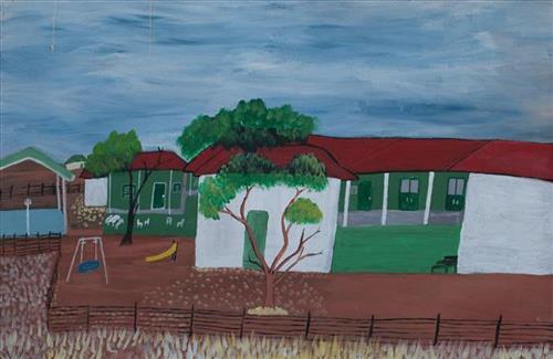
The school is different now. It’s grown a lot. There are more buildings, and a new basketball court was recently built. A lot of people have worked hard to make the school a good place.

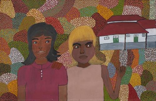
This painting shows the Parnngurr School and two of my granddaughters, Yvette and Jessica. My granddaughters attended Parnngurr School when they were kids, they’re teenagers now.”

 – Noreena Kadibil


Noreena Kadibil is a Martu artist currently living in Parnngurr community. Noreena is known for her historical paintings, sharing significant family histories through her work. Noreena regularly paints the Parnngurr School. Community schools are vital components of remote communities, enabling young families to continue living in community, providing employment and an opportunity for two-way learning.

Noreena has close ties to Parnngurr School. She was employed as a Martu teacher when the school was first formed, and many of her children and grandchildren have either attended or been employed by the school. Depicting her grandchildren alongside Parnngurr School illustrates the continuing importance of the school within Noreena’s family and the wider community.


111581715953


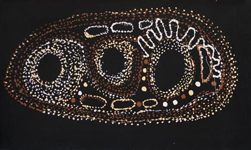
Untitled

“When Martu paint, it’s like a map. Martu draw story on the ground and on the canvas, and all the circle and line there are the hunting areas and different waters and tracks where people used to walk, and [some you] can’t cross, like boundaries. So nowadays you see a colourful painting and wonder what it is, but that’s how Martu tell story long ago. It’s not just a lovely painting, it’s a story and a songline and a history and everything that goes with it.” 

– Ngalangka Nola Taylor and Joshua Booth

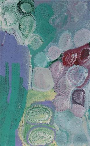
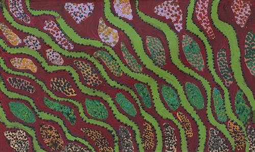
This work portrays an area of Country that can be interpreted in multiple ways. Firstly, the image may be read as an aerial representation of a particular location known to the artist- either land that they or their family travelled, from the pujiman (traditional, desert dwelling) era to now. During the pujiman period, Martu would traverse very large distances annually in small family groups, moving seasonally from water source to water source, and hunting and gathering bush tucker as they went. At this time, one’s survival depended on their intimate knowledge of the location of resources; thus physical elements of Country, such as sources of kapi (water), tali (sandhills), different varieties of warta (trees, vegetation), ngarrini (camps), and jina (tracks) are typically recorded with the use of a use of a system of iconographic forms universally shared across the desert. 

An additional layer of meaning in the work relates to more intangible concepts; life cycles based around kalyu (rain, water) and waru (fire) are also often evident. A thousands of year old practice, fire burning continues to be carried out as both an aid for hunting and a means of land management today. As the Martu travelled and hunted they would burn tracts of land, ensuring plant and animal biodiversity and reducing the risk of unmanageable, spontaneous bush fires. The patchwork nature of regrowth is evident in many landscape works, with each of the five distinctive phases of fire burning visually described with respect to the cycle of burning and regrowth.  

Finally, metaphysical information relating to a location may also be recorded; jukurrpa (dreaming) narratives chronicle the creation of physical landmarks, and can be referenced through depictions of ceremonial sites, songlines, and markers left in the land. Very often, however, information relating to jukurrpa is censored by omission, or alternatively painted over with dotted patterns.

111581733962


All The Tuwa (Sandhills)

The traditional lands of the Martu people encompass the Great Sandy Desert and Rudall River regions of Western Australia, an enormous tract dominated by distinctive red tali, or tuwa (sandhills). These sandhills present an unforgiving landscape; sparse vegetation covers a seemingly never ending expanse of dunes, and yet these lands and the location of resources within them was known intimately by its pujiman (traditional, desert dwelling) inhabitants. At this time, Martu traversed very large distances annually in small family groups, moving from water source to water source through the harsh desert landscape with incredible stamina and resourcefulness. Travel was often undertaken at night, and when travelling during the day, Martu wore yakipiri (woven bark sandals) to protect their feet from the hot desert sand.

111581739961


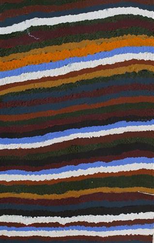
Untitled

“When Martu paint, it’s like a map. Martu draw story on the ground and on the canvas, and all the circle and line there are the hunting areas and different waters and tracks where people used to walk, and [some you] can’t cross, like boundaries. So nowadays you see a colourful painting and wonder what it is, but that’s how Martu tell story long ago. It’s not just a lovely painting, it’s a story and a songline and a history and everything that goes with it.” 

– Ngalangka Nola Taylor and Joshua Booth

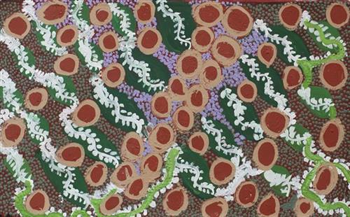
This work portrays an area of Country that can be interpreted in multiple ways. Firstly, the image may be read as an aerial representation of a particular location known to the artist- either land that they or their family travelled, from the pujiman (traditional, desert dwelling) era to now. During the pujiman period, Martu would traverse very large distances annually in small family groups, moving seasonally from water source to water source, and hunting and gathering bush tucker as they went. At this time, one’s survival depended on their intimate knowledge of the location of resources; thus physical elements of Country, such as sources of kapi (water), tali (sandhills), different varieties of warta (trees, vegetation), ngarrini (camps), and jina (tracks) are typically recorded with the use of a use of a system of iconographic forms universally shared across the desert. 

An additional layer of meaning in the work relates to more intangible concepts; life cycles based around kalyu (rain, water) and waru (fire) are also often evident. A thousands of year old practice, fire burning continues to be carried out as both an aid for hunting and a means of land management today. As the Martu travelled and hunted they would burn tracts of land, ensuring plant and animal biodiversity and reducing the risk of unmanageable, spontaneous bush fires. The patchwork nature of regrowth is evident in many landscape works, with each of the five distinctive phases of fire burning visually described with respect to the cycle of burning and regrowth.  

Finally, metaphysical information relating to a location may also be recorded; jukurrpa (dreaming) narratives chronicle the creation of physical landmarks, and can be referenced through depictions of ceremonial sites, songlines, and markers left in the land. Very often, however, information relating to jukurrpa is censored by omission, or alternatively painted over with dotted patterns.

111581739958


Untitled

“When Martu paint, it’s like a map. Martu draw story on the ground and on the canvas, and all the circle and line there are the hunting areas and different waters and tracks where people used to walk, and [some you] can’t cross, like boundaries. So nowadays you see a colourful painting and wonder what it is, but that’s how Martu tell story long ago. It’s not just a lovely painting, it’s a story and a songline and a history and everything that goes with it.” 

– Ngalangka Nola Taylor and Joshua Booth

This work portrays an area of Country that can be interpreted in multiple ways. Firstly, the image may be read as an aerial representation of a particular location known to the artist- either land that they or their family travelled, from the pujiman (traditional, desert dwelling) era to now. During the pujiman period, Martu would traverse very large distances annually in small family groups, moving seasonally from water source to water source, and hunting and gathering bush tucker as they went. At this time, one’s survival depended on their intimate knowledge of the location of resources; thus physical elements of Country, such as sources of kapi (water), tali (sandhills), different varieties of warta (trees, vegetation), ngarrini (camps), and jina (tracks) are typically recorded with the use of a use of a system of iconographic forms universally shared across the desert. 

An additional layer of meaning in the work relates to more intangible concepts; life cycles based around kalyu (rain, water) and waru (fire) are also often evident. A thousands of year old practice, fire burning continues to be carried out as both an aid for hunting and a means of land management today. As the Martu travelled and hunted they would burn tracts of land, ensuring plant and animal biodiversity and reducing the risk of unmanageable, spontaneous bush fires. The patchwork nature of regrowth is evident in many landscape works, with each of the five distinctive phases of fire burning visually described with respect to the cycle of burning and regrowth.  

Finally, metaphysical information relating to a location may also be recorded; jukurrpa (dreaming) narratives chronicle the creation of physical landmarks, and can be referenced through depictions of ceremonial sites, songlines, and markers left in the land. Very often, however, information relating to jukurrpa is censored by omission, or alternatively painted over with dotted patterns.

111581849271


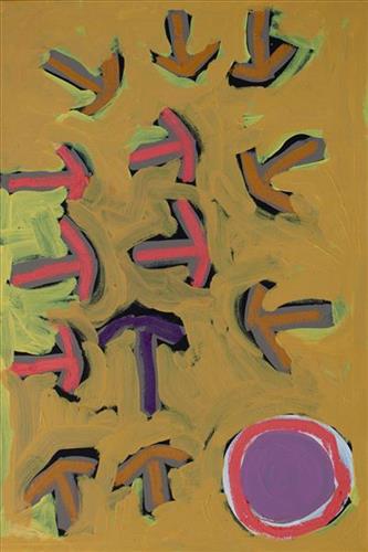
Emu Tracks to Puntawarri

“Emu go to the springs to have a drink of water and then move on to the next one.”

– Judith Anya Samson

Puntawarri is an important cultural area, as well as the site of a now abandoned community, a waterhole, creek and lake. Puntawarri is located on the middle stretches of the Canning Stock Route and east of the Jigalong Aboriginal Community, where Judith grew up with her grandmother and senior Martumili Artist Dadda Samson. Both artists continue to live there today.

Puntawarri lies within Judith’s ngurra (home Country, camp) through her mother’s family, and as a young girl she frequently travelled and hunted with her family in this area, learning the stories for this Country. Depicted in this work are the tracks of a group of emus on their way to Puntawarri waterhole, searching for kapi (water). 

Karlaya (emu) were traditionally hunted during the pujiman (traditional, desert dwelling) era, and they continue to be a favoured bush tucker for Martu today. During the pujiman (traditional, desert dwelling) period, Martu would traverse very large distances annually in small family groups, moving seasonally from water source to water source, and hunting and gathering bush tucker as they went. Jina (tracks, footprints) are used by Martu people when tracking bush tucker. In the absence of an actual animal sighting, tracks act as an identifier that an animal was present, which can then be followed to the animal’s present location. Besides providing information on location, Martu are able to interpret from tracks the passage of time since the tracks were imprinted, as well as the corresponding animal species and its size.

The softer and more extensive the ground surface, the easier it is to locate and follow tracks, thus certain conditions are favoured for tracking. Tuulparra (spring) and yalijarra (hot time) are preferred over wantajarra (winter), when south easterly tradewinds blow strongly to obscure tracks. Tracks and burrows are also more readily visible in early growth lands, such as nyurnma (freshly burnt Country) and waru-waru (growth of new shoots and young plants). For this reason, fire burning is an important tool in animal tracking. Small burns are lit to clear vegetation, expose burrows, and to allow for access to walk and track readily in exposed sands, while simultaneously providing diverse regenerating habitats.