111582210723


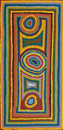
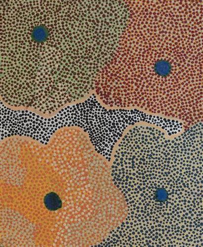
Untitled

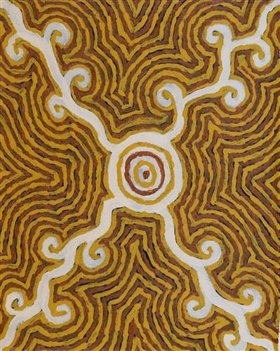
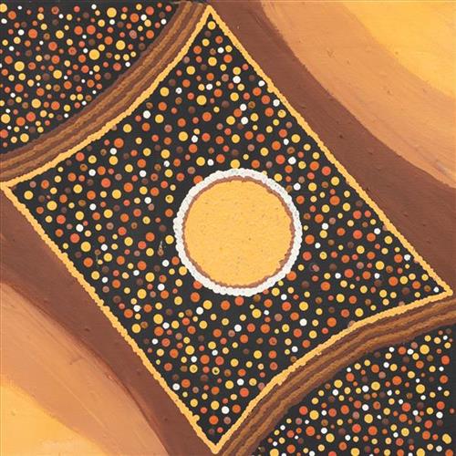
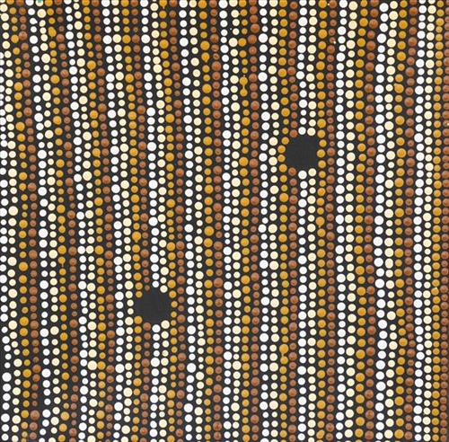
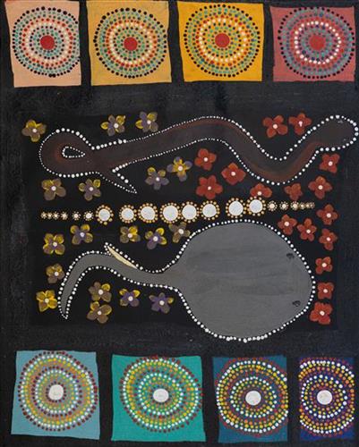
This work portrays an area known intimately to the artist, painted here from memory. During the pujiman (traditional, desert dwelling) era one’s survival depended on their intimate knowledge of the location of resources; thus physical elements of Country, such as sources of kapi (water), tali (sandhills), and different varieties of warta (trees, vegetation) were carefully observed and remembered. Today, this relationship with Country remains equally strong, despite the movement of Martu out of the desert and into remote Aboriginal communities, towns and cities.

Also visible may be traces of life cycles based around kalyu (rain, water) and waru (fire). A thousands of year old practice, fire burning continues to be carried out as both an aid for hunting and a means of land management today. As the Martu travelled and hunted they would burn tracts of land, ensuring plant and animal biodiversity and reducing the risk of unmanageable, spontaneous bush fires. The patchwork nature of regrowth is visible in many landscape works, with each of the five distinctive phases of fire burning visually described with respect to the cycle of burning and regrowth.  

Finally, metaphysical information relating to a location may also be recorded; Jukurrpa (Dreaming) narratives chronicle the creation of physical landmarks, and can be referenced through depictions of ceremonial sites, songlines, and markers left in the land. 
111582210722


Jutupa

Jutupa is a waterhole located yulparirra (south) of Punmu Aboriginal Community, and at the southern edge of Nyayartakujarra (Ngayarta Kujarra, Lake Dora). The site falls within the Karlamilyi (Rudall River) region, an area created by the Jila Kujarra (Two Snakes) as they journeyed north east to Nyayartakujarra. Surrounding Jutupa are the distinctive long tali (sandhills) of Martu Country. Other nearby water sources include Pinjupinya, Wawul, Tarl, and Jarntinti.

This site lies within Nyanjilpayi’s ngurra (home Country, camp), the area which she travelled extensively around with her family as a young girl. Nyanjilpayi recollects staying here as a child with her two Sisters, Mayiwalku May Chapman and Mulyatingki Marney, her brother, father and three mothers. Here they would collect kalaru (Samphire, salt bush) seed. In the pujiman (traditional, desert dwelling) era, the black kalaru seeds were used to produce damper, a type of flat bread. The seeds were first washed several times before being ground with a jiwa (stones used by women for grinding seeds) to make a flour, which was then mixed with water to create a dough that was finally cooked in the ashes of a fire.

111582210721


Kurturarra

“Kurturarra is my Grandmother’s Country. Warla (lake) with a spring. Tali (sandhills) all around.”

 – Beverley Rogers

This site lies within Beverley’s ngurra (home Country, camp) through her grandmother. Kurturarra is a yinta (permanent spring) located within the largest of the salt lakes in the Percival Lakes region, and surrounded by acacia trees. The Percival Lakes form a string of ephemeral salt lakes in the north of Western Australia, extending across a distance of 350km. They lie at the southern region of the Great Sandy Desert and east of the Karlamilyi (Rudall River) region.

The region surrounding Kurturarra was formed by Wirnpa, one of the most powerful of the ancestral jila (snake) men and the last to travel the desert during the Jukurrpa (Dreaming). Wirnpa is a rainmaking jila who lived and hunted in the Percival Lakes area. His travels are described in the songs and stories of many language groups across the Western Desert, even those far removed from his home site. In his epic travels, Wirnpa met and feasted with many other ancestral beings, exchanged ceremonial objects, and created a series of different laws and ceremonies. When he finally returned home, he searched for his many children only to discover that they had already died. They had laid down and become the salt springs of the Percival Lakes. Wirnpa wept for his children before himself transforming into a snake and entering the soak where he still resides.

111582210720


Kurturarra

“Kurturarra is my Grandmother’s Country. Warla (lake) with a spring. Tali (sandhills) all around.”

 – Beverley Rogers

This site lies within Beverley’s ngurra (home Country, camp) through her grandmother. Kurturarra is a yinta (permanent spring) located within the largest of the salt lakes in the Percival Lakes region, and surrounded by acacia trees. The Percival Lakes form a string of ephemeral salt lakes in the north of Western Australia, extending across a distance of 350km. They lie at the southern region of the Great Sandy Desert and east of the Karlamilyi (Rudall River) region.

The region surrounding Kurturarra was formed by Wirnpa, one of the most powerful of the ancestral jila (snake) men and the last to travel the desert during the Jukurrpa (Dreaming). Wirnpa is a rainmaking jila who lived and hunted in the Percival Lakes area. His travels are described in the songs and stories of many language groups across the Western Desert, even those far removed from his home site. In his epic travels, Wirnpa met and feasted with many other ancestral beings, exchanged ceremonial objects, and created a series of different laws and ceremonies. When he finally returned home, he searched for his many children only to discover that they had already died. They had laid down and become the salt springs of the Percival Lakes. Wirnpa wept for his children before himself transforming into a snake and entering the soak where he still resides.

111582210719


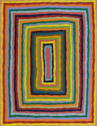
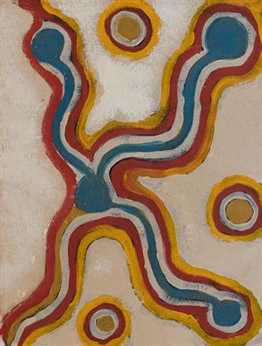
Untitled

“When Martu paint, it’s like a map. Martu draw story on the ground and on the canvas, and all the circle and line there are the hunting areas and different waters and tracks where people used to walk, and [some you] can’t cross, like boundaries. So nowadays you see a colourful painting and wonder what it is, but that’s how Martu tell story long ago. It’s not just a lovely painting, it’s a story and a songline and a history and everything that goes with it.” 

– Ngalangka Nola Taylor and Joshua Booth

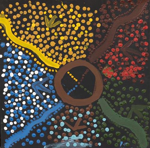
This work portrays an area of Country that can be interpreted in multiple ways. Firstly, the image may be read as an aerial representation of a particular location known to the artist- either land that they or their family travelled, from the pujiman (traditional, desert dwelling) era to now. During the pujiman period, Martu would traverse very large distances annually in small family groups, moving seasonally from water source to water source, and hunting and gathering bush tucker as they went. At this time, one’s survival depended on their intimate knowledge of the location of resources; thus physical elements of Country, such as sources of kapi (water), tali (sandhills), different varieties of warta (trees, vegetation), ngarrini (camps), and jina (tracks) are typically recorded with the use of a use of a system of iconographic forms universally shared across the desert. 

An additional layer of meaning in the work relates to more intangible concepts; life cycles based around kalyu (rain, water) and waru (fire) are also often evident. A thousands of year old practice, fire burning continues to be carried out as both an aid for hunting and a means of land management today. As the Martu travelled and hunted they would burn tracts of land, ensuring plant and animal biodiversity and reducing the risk of unmanageable, spontaneous bush fires. The patchwork nature of regrowth is evident in many landscape works, with each of the five distinctive phases of fire burning visually described with respect to the cycle of burning and regrowth.  

Finally, metaphysical information relating to a location may also be recorded; Jukurrpa (Dreaming) narratives chronicle the creation of physical landmarks, and can be referenced through depictions of ceremonial sites, songlines, and markers left in the land. Very often, however, information relating to Jukurrpa is censored by omission, or alternatively painted over with dotted patterns.
111582210718


Mirrpurn (also known as Jarntinti) – it’s close [to Punmu]

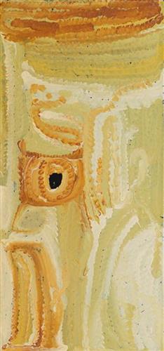
Mirrpurn is a large claypan at the southern end of Nyayartakujarra (Lake Dora), a large salt lake surrounded by tali (sand hills) within the Karlamilyi (Rudall River) region. During the pujiman (traditional, desert dwelling) era, Mirrpurn was primarily used as a camping site in the wantajarra (wet season), when the claypan filled with kapi (water). Other nearby water sources include Tarl, Kartuny, Wawul, Warnkarr, Jutupa, and Kunalimpi. 

Mirrpurn is also known as a site where kalaru (Samphire, salt bush) grows in abundance. In the pujiman era, the black kalaru seeds were seasonally harvested from this area. Once collected a labour intensive process began to produce damper, a type of flat bread. The kalaru seeds were first washed several times before being ground with a jiwa (stones used by women for grinding seeds) to make a type of flour, which was then mixed with water to create a dough that was finally cooked in the ashes of a fire.

111582210717


Nyilangkurr

“My father finished at Nyilangkurr. This is my Country. These are the claypans; some have water in them. This here sand dunes. This is my mummy’s ngurra (home Country, camp). 

 – Jakayu Biljabu, as translated by granddaughters Morika and Renette Biljabu 

Nyilangkurr is a group of three large tali (sandhills) located between Kartarru (Canning Stock Route Well 24) and Tiwa (Canning Stock Route 26), and just east of Wantili, an important creation site. Nyilangkurr holds special significance for Jakayu; this is her mother’s ngurra (home Country, camp), as well as the site where her father passed away. Jakayu grew up in the area around these sites and beyond, she knew this region intimately and travelled extensively here with her family in her youth. 

The Western Desert term ‘ngurra’ is hugely versatile in application. Broadly denoting birthplace and belonging, ngurra can refer to a body of water, a camp site, a large area of Country, or even a modern house. People identify with their ngurra in terms of specific rights and responsibilities, and the possession of intimate knowledge of the physical and cultural properties of one’s Country. This knowledge is traditionally passed intergenerationally through family connections. Painting ngurra, and in so doing sharing the Jukurrpa (Dreaming) stories and physical characteristics of that place, has today become an important means of cultural maintenance. Physical maintenance of one’s ngurra, like cultural maintenance, ensures a site’s wellbeing, and is a responsibility of the people belonging to that area.

111582210716


Untitled

“When Martu paint, it’s like a map. Martu draw story on the ground and on the canvas, and all the circle and line there are the hunting areas and different waters and tracks where people used to walk, and [some you] can’t cross, like boundaries. So nowadays you see a colourful painting and wonder what it is, but that’s how Martu tell story long ago. It’s not just a lovely painting, it’s a story and a songline and a history and everything that goes with it.” 

– Ngalangka Nola Taylor and Joshua Booth

This work portrays an area of Country that can be interpreted in multiple ways. Firstly, the image may be read as an aerial representation of a particular location known to the artist- either land that they or their family travelled, from the pujiman (traditional, desert dwelling) era to now. During the pujiman period, Martu would traverse very large distances annually in small family groups, moving seasonally from water source to water source, and hunting and gathering bush tucker as they went. At this time, one’s survival depended on their intimate knowledge of the location of resources; thus physical elements of Country, such as sources of kapi (water), tali (sandhills), different varieties of warta (trees, vegetation), ngarrini (camps), and jina (tracks) are typically recorded with the use of a use of a system of iconographic forms universally shared across the desert. 

An additional layer of meaning in the work relates to more intangible concepts; life cycles based around kalyu (rain, water) and waru (fire) are also often evident. A thousands of year old practice, fire burning continues to be carried out as both an aid for hunting and a means of land management today. As the Martu travelled and hunted they would burn tracts of land, ensuring plant and animal biodiversity and reducing the risk of unmanageable, spontaneous bush fires. The patchwork nature of regrowth is evident in many landscape works, with each of the five distinctive phases of fire burning visually described with respect to the cycle of burning and regrowth.  

Finally, metaphysical information relating to a location may also be recorded; Jukurrpa (Dreaming) narratives chronicle the creation of physical landmarks, and can be referenced through depictions of ceremonial sites, songlines, and markers left in the land. Very often, however, information relating to Jukurrpa is censored by omission, or alternatively painted over with dotted patterns.
111582210715


My grandfather’s Country (Junpunjunya, Junpunkutja)

“That’s my great, great grand parent’s Country. My grandfathers’ and grandmother’s Country. You go through 33 Well (Kunawarritji, Canning Stock Route Well 33).”

– Marianne Burton

This work depicts two specific sites that form part of Marianne’s ngurra (home Country, camp) through her great, great grandparents. The Western Desert term ‘ngurra’ is hugely versatile in application. Broadly denoting birthplace and belonging, ngurra can refer to a body of water, a camp site, a large area of Country, or even a modern house. People identify with their ngurra in terms of specific rights and responsibilities, and the possession of intimate knowledge of the physical and cultural properties of one’s Country. This knowledge is traditionally passed intergenerationally through family connections. Country for Martu is full of memory; not just the memory of their own movement through it, but also of their family. As summarised by Ngalangka Nola Taylor, “painting the ngurra, they do it to remember their connections.” 

Painting ngurra, and in so doing sharing the Jukurrpa (Dreaming) stories and physical characteristics of that place, has today become an important means of cultural maintenance. Physical maintenance of one’s ngurra, like cultural maintenance, ensures a site’s wellbeing, and is a responsibility of the people belonging to that area.

111582210714


Untitled

“When Martu paint, it’s like a map. Martu draw story on the ground and on the canvas, and all the circle and line there are the hunting areas and different waters and tracks where people used to walk, and [some you] can’t cross, like boundaries. So nowadays you see a colourful painting and wonder what it is, but that’s how Martu tell story long ago. It’s not just a lovely painting, it’s a story and a songline and a history and everything that goes with it.” 

– Ngalangka Nola Taylor and Joshua Booth

This work portrays an area of Country that can be interpreted in multiple ways. Firstly, the image may be read as an aerial representation of a particular location known to the artist- either land that they or their family travelled, from the pujiman (traditional, desert dwelling) era to now. During the pujiman period, Martu would traverse very large distances annually in small family groups, moving seasonally from water source to water source, and hunting and gathering bush tucker as they went. At this time, one’s survival depended on their intimate knowledge of the location of resources; thus physical elements of Country, such as sources of kapi (water), tali (sandhills), different varieties of warta (trees, vegetation), ngarrini (camps), and jina (tracks) are typically recorded with the use of a use of a system of iconographic forms universally shared across the desert. 

An additional layer of meaning in the work relates to more intangible concepts; life cycles based around kalyu (rain, water) and waru (fire) are also often evident. A thousands of year old practice, fire burning continues to be carried out as both an aid for hunting and a means of land management today. As the Martu travelled and hunted they would burn tracts of land, ensuring plant and animal biodiversity and reducing the risk of unmanageable, spontaneous bush fires. The patchwork nature of regrowth is evident in many landscape works, with each of the five distinctive phases of fire burning visually described with respect to the cycle of burning and regrowth.  

Finally, metaphysical information relating to a location may also be recorded; Jukurrpa (Dreaming) narratives chronicle the creation of physical landmarks, and can be referenced through depictions of ceremonial sites, songlines, and markers left in the land. Very often, however, information relating to Jukurrpa is censored by omission, or alternatively painted over with dotted patterns.