377810582290977


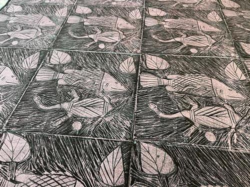
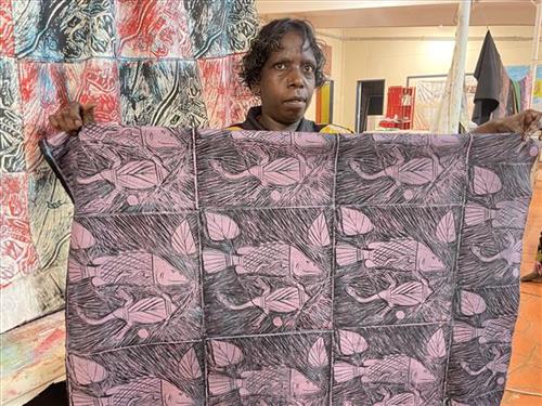
Barramundi and Long Neck Turtle

This fabric was created using the linocut printing technique. The lino tile has been carved by the artist in Maningrida, and has been printed by hand using a variety of colours and layers. The linocut technique ensures each textile piece is a one-off, limited edition piece. Bábbarra Women’s Centre supports the economic independence of Indigenous women in the Arnhem Land community of Maningrida, Northern Territory, Australia. Designs created by the women at Bábbarra reflect strong cultural knowledge, which is passed down to younger generations through their textile design practice.

111982290958


Yawkyawk

Yawkyawk is a word in the Kunwinjku/Kunwok language of Western Arnhem Land meaning ‘young woman’ and ‘young woman spirit being’. The different groups of Kunwinjku people (one of the Eastern dialect groups call themselves Kuninjku) each have Yawkyawk mythologies, which relate to specific locations in clan estates. These mythologies are represented in bark paintings and sculptures of Yawkyawk beings. There are also a few examples of rock art images of these beings.
The female water spirits Yawkyawk or Ngalkunburriyaymi are perhaps the most enigmatic of mythological themes. Sometimes compared to the European notion of mermaids, they exist as spiritual beings living in freshwater streams and rock pools, particularly those in the stone country. The spirit Yawkyawk is usually described and depicted with the tail of a fish. Thus the Kuninjku people sometimes call them ngalberddjenj which literally means ‘the young woman who has a tail like a fish’. They have long hair, which is associated with trailing blooms of green algae (called man-bak in Kuninjku). At times they leave their aquatic homes to walk about on dry land, particularly at night.
Aboriginal people believe that in the beginning most animals were humans. During the time of the creation of landscapes and plants and animals, these ancestral heroes in human form transmutated into their animal forms via a series of various significant events now recorded as oral mythologies. The creation ancestor Yawkyawk travelled the country in human form and changed into the form of Ngalkunburriyaymi as a result of various ancestral adventures. Today the Kuninjku believe that Ngalkunburriyaymi are alive and well and living in freshwater sites in a number of sacred locations.
Some features of a respective country are equated with body parts of Yawkyawk. For example a bend in a river or creek may be said to be ‘the tail of the Yawkyawk, a billabong may be ‘the head of the Yawkyawk and so on. Thus different groups can be linked together by means of a shared mythology featured in the landscape, which crosscuts clan and language group boundaries.

111982290942


Gulach (Spike Rush)

Greg Wilson is the son of artist Terry Ngamandara, who was a senior custodian of the Gun-gulol Gu-rrenyjinga group of clans, which includes his own clans Girnimba and Garramirra. These clans are all land owners for different areas of the large swamp called Barlparnarra which lies to the north-west of Gochan Jiny-jirra outstation on the Cadell River. Barlparnarra is a complex of important sacred sites for the Jowunga moiety group throughout central Arnhem Land. It is associated with the creation myth of the two sisters, which has a number of versions celebrated throughout Arnhem Land. The sisters are commonly known as Djangkawu, but in the Barlparnarra version they are called Murlurlu. Many dreaming tracks of mythological beings associated with the two sisters converge at this site and ceremonies which celebrate their journeys are still held there.

The artist has depicted a key emblem for the Gun-gulol Gu-rrenyjinga clans. It is a design for gulach, the spike rush, also known as water chestnut (Eleocharis dulcis) that dominates the Barlparnarra swamp country. The emblem appears as triangular motifs which cover the entire painting. The spike rush plant has edible corms which form a food source for magpie geese, a key swamp game animal. People also dig and eat the sweet corms.

111582291212


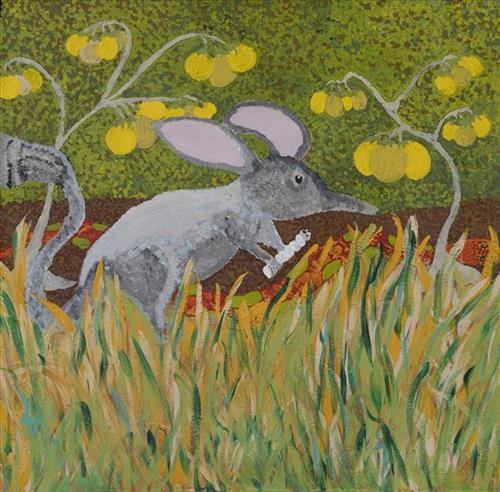
Young Bilby

“Those three animals we protect them now. The old people use to eat the animals and we’re working with the KJ (Kanyirninpa Jukurrp Ranger) mob to protect them. The top one (Mangkarr) is taller than this one (middle – Nurta). This one (Nurta) is stumpy like a guinea pig. The bottom one (Winyminji) is the same size as a cat. It’s like a cat.”

– Carol Williams

Mankarr (Greater Bilby) is a type of desert-dwelling omnivore, found in a range of habitats from rocky soils, shrublands, woodlands and spinifex regions. Its fur is usually grey or white, and has a long, sharp nose and long pinkish ears. At the time of European colonisation of Australia, there were two species. The lesser bilby became extinct in the 1950s, while the greater bilby has survived, it remains a threatened species.

The Nurta (desert bandicoot), was a bandicoot of the central and western dessert, considered to be extinct since 2016. It was small in size with a long and narrow head which it used to investigate the sand while digging. It had orange-brow fur on its back and white below, with one or two dark bands on the hindquarters. The decline and extinction of the desert bandicoot is attributed to a range of factors including predation by cats and foxes, and habitat destruction due to the impacts of exotic herbivores and to changed fire regimes

Winyminji (Quolls) are carnivorous marsupials also native to Australia. They are primarily nocturnal and spend most of the day in a den. They have brown or black fur and pink noses. They are largely solitary, but come together for a few social interactions such as mating which occurs during the winter season. Quolls eat smaller mammals, small birds, lizards, and insects. All species have drastically declined in numbers since Australasia was colonised by Europeans, with one species, the eastern quoll, becoming extinct in the 1960s.

KJ program manage the conservation of the natural and cultural assets on Martu country through the employment of Martu as Indigenous rangers.  KJ rangers work to build knowledge on and protect the many important species that occur on their country, including the Mankarr, the wiminyji and the mulyamiji (great desert skink).

111582291210


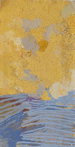
Wantili (Warntili, Canning Stock Route Well 25)

“Wantili (Warntili, Canning Stock Route Well 25) area, close to Parnngurr. My ngurra (home Country, camp), my jamu’s (grandfather’s) Country, my father’s daddy, Jakayu [Biljabu’s] daddy and my daddy’s Country. Jakayu been bury her father there. In pujiman (traditional, desert dwelling) days, my family and Jakayu’s family been walking round there together. Big sandhills here. Sandhill, sandhill, sandhill everywhere. Claypan there, in the middle. Good place for swimming and drinking, for hunting little kangaroo. When no water [we would] go to [the adjacent Canning Stock Route] well. When there [was] rain we stay there at Wantili. Everywhere, we been walking everywhere.       

Near to Wantili, road [Canning Stock Route] going kayili (north). Long time [ago] only horses and cattle [travelled along that road], going Meekatharra and back in the cold time, gone right up to GJ (Georgia) Bore. Half way, when he see water at Wantili, that mob would camp one night, bullock eating all the grass and men’s drinking water. One Martu been working with that mob, droving bullock. Every time he been give us meat, all the pujimanpa (desert dwellers).”

– Ngamaru Bidu


Wantili is a large round jurnu (soak) and linyji (claypan) near Well 25 on the Canning Stock Route. The Wantili region is dominated by claypans surrounded by tuwa (sandhills), and Nyilangkurr, a prominent yapu (hill) is located close to the eastern edge of the claypan. Following rain the typically dry claypans are filled with water, with the overflow from nearby waterholes flowing to Wantili. At that time, Wantili becomes an important place for obtaining fresh water for drinking and bathing. Wantili is significant for the fact that at this site Kartujarra, Manyjilyjarra, Putijarra and Warnman people would all come together for ceremonies during the pujiman era. Many jiwa (stones used by women for grinding seeds) from these times, including those used by Ngamaru’s family, can still be found there today.

Wantili lies within Ngamaru’s ngurra (home Country, camp) through her grandfather and father. As described in her account, Wantili was one of the sites Ngamaru knew intimately and travelled extensively with her family and other family groups, such as the Biljabu family. During the pujiman period Martu would traverse very large distances annually, moving seasonally from water source to water source, and hunting and gathering bush tucker as they went. Knowledge of water sources was critical for survival, and today Martu Country is still defined in terms of the location and type of water. 

As Ngamaru recounts, Wantili also held significance for her as a site of contact between her family and kartiya (white people); drovers with their cattle travelling along the Canning Stock Route. The establishment of the route by Alfred Canning and his team in 1910 resulted in first contact with Europeans for many Martu, including Ngamaru and her family. Increasingly, Martu followed the route to newly established ration depots, mission and pastoral stations. They were drawn to the route in search of food, by a sense of curiosity, or by loneliness. By the late 1950s and early 1960s, most of the desert family groups had left the desert. Eventually, these factors combined with an extreme and prolonged drought in the 1960s to prompt the few remaining pujimanpa to move in from the desert. 

Culturally, Wantili is an incredibly important site in two central Jukurrpa (Dreaming) stories. The first relates to the world’s creation. In this narrative, the world was initially dark, and people were like rocks, with no arms or legs. Following the sun’s first rising, life-forms become increasingly complex while particular features in the land are created. Beyond these details much of the narrative is ngurlu (sacred, taboo), and only for Martu, but the site is open, and anyone can go there. 

Wantili is also one of the many sites featured in the epic Minyipuru (Jakulyukulyu, Seven Sisters) Jukurrpa story. Minyipuru is a central Jukurrpa narrative for Martu, Ngaanyatjarra, Pitjantjatjara and Yankunytjatjara people that is associated with the seasonal Pleiades star constellation. Relayed in song, dance, stories and paintings, Minyipuru serves as a creation narrative, a source of information relating to the physical properties of the land, and an embodiment of Aboriginal cultural laws. The story follows the movement of a group of women travelling all the way across the desert, beginning at Roebourne on the coast of Western Australia, as they are pursued by Yurla, a lustful old man. As the women travelled, they stopped to rest at many sites to eat, dance, rest and sing, on the way leaving behind an assortment of articles that became formations in the land, such as groupings of rocks and trees, grinding stones and seeds. The sisters rested at Wantili before throwing seeds, then continued their journey far to the east and beyond Martu Country, stopping at various sites through central and South Australia.

111582291209


Kunawarritji Rockholes

“These are the rockholes around Kunawarritji (Canning Stock Route Well 33). My mum [Jugarda Dulcie Gibbs] painted the same. It’s my father’s Country; he was born at Well 33. I’m painting Well 35, Kinyu, all the way to Well 38, Wajaparni. This is a big place for us. It’s important. I went on a trip with Kanyirninpa Jukurrpa [ranger group] last year [2018] to visit all these rockholes.”

– Pauline Williams 

Kunawarritji is an important site in the Great Sandy Desert where multiple stories and histories intersect. The area forms part of Pauline’s ngurra (home Country, camp) through her family. Originally a spring water and major Martu pujiman (traditional, desert dwelling) camping site, at the turn of the 20th century Kunawarritji was converted into a well along the Canning Stock Route. Each year throughout the 1930-50s, the well became a site of contact between the drovers, their cattle, and desert families.

Long before colonial history entered this Country, however, other stories dominated the site. Primarily, Kunawarritji features in the Minyipuru (Jakulyukulyu, Seven Sisters) Jukurrpa (Dreaming). Minyipuru is a central Jukurrpa narrative for Martu, Ngaanyatjarra, Pitjantjatjara and Yankunytjatjara people that is associated with the seasonal Pleiades star constellation. Today, Kunawarritji is a site of return, a place where people came back to continue their life in the desert with the formation of Kunawarritji Aboriginal community in the early 1980s. The community’s cultural significance endures, with the population swelling up to 1000 during cultural business. 

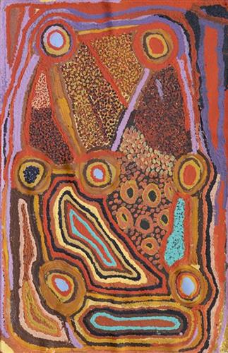
As Pauline states in her account, this work depicts the waterholes and tali (sandhills) in the area surrounding Kunawarritji, typically represented with circular forms. During the pujiman period, knowledge of water sources was critical for survival, and today Martu Country is still defined in terms of the location and type of water. Each of the hundreds of claypans, rockholes, waterholes, soaks and springs found in the Martu desert homelands is known through real life experience and the recounting of Jukurrpa narratives by name, location, quality and seasonal availability.

Transfer of cultural knowledge through visual arts is an important way for Martu artists to keep their culture strong. Younger Martu artists like Pauline typically begin painting with their parents, grandparents and extended family, thus fostering an organic process of learning, not only about painting techniques, but also specific locations, family histories, traditional ways of life, bush tucker and  Jukurrpa. 

111582291208


Yimiri

Yimiri comprises two freshwater soaks situated in the middle of a salt lake in the Percival Lakes area, within Western Australia’s Great Sandy Desert. Around these soaks the Country is dominated by permanent tuwa (sand hills). When visiting this site to drink water, the bulrushes surrounding the soaks are pushed back to access the kapi (water). 

Yimiri is home to an ancestral jila (snake). The Western Desert term jila is used interchangeably to describe springs considered to be ‘living’ waters and snakes, both of which play a central role in Martu culture and Jukurrpa (Dreaming). During the pujiman (traditional, desert dwelling) period, knowledge of water sources was critical for survival, and today Martu Country is still defined in terms of the location of water sources. Of the many permanent springs in Martu Country, very few are ‘living waters’; waters inhabited by jila. Before they became snakes, these beings were men who made rain, formed the land and introduced cultural practices like ceremonies and ritual songs. Some of the men travelled the desert together, visiting one another, but they all ended their journeys at their chosen spring alone, transformed into a snake. These important springs are named after their jila inhabitant, guarding their waters.

The region surrounding Yimiri was formed by Wirnpa, one of the most powerful of the ancestral jila (snake) men and the last to travel the desert during the Jukurrpa. Wirnpa is a rainmaking jila who lived and hunted in the Percival Lakes area. His travels are described in the songs and stories of many language groups across the Western Desert, even those far removed from his home site. In his epic travels, Wirnpa met and feasted with many other ancestral beings, exchanged ceremonial objects, and created a series of different laws and ceremonies. When he finally returned home, he searched for his many children only to discover that they had already died. They had laid down and become the salt springs of the Percival Lakes. Wirnpa wept for his children before himself transforming into a snake and entering the soak where he still resides. 

During the pujiman period, Martu would traverse very large distances annually in small family groups, moving seasonally from water source to water source, and hunting and gathering bush tucker as they went. At this time knowledge of water sources was critical for survival, and today Martu Country is still defined in terms of the location and type of water. Each of the hundreds of claypans, rockholes, waterholes, soaks and springs found in the Martu desert homelands is known by name, location, quality and seasonal availability through real life experience and the recounting of Jukurrpa narratives.

111582291206


Untitled

How did you get to this style of painting?

“Do you mean, what have I done with my life? (chuckles to herself) To me these paintings are a sense of energy. So if I see someone and they’re happy, I paint a happy vibe. Cos their spirit is happy. And sometimes it’s hard because on the outside they’re real happy but on the inside they’re real sad. Sometimes you do stuff (like a painting) and it adds up later on. But I still don’t know what it means and don’t know where my style comes from because it’s both the path I walk on and the cracks in the dirt. It’s like looking at a landscape but I haven’t been there yet. Maybe I’ll get there one day. I believe things happen for a reason.”

– Sylvia Wilson

111582291204


Mungili Waterholes and Rock Holes

“I was swimming there. Yeah, we go visit them a long time [ago]. We drink it, rain water from the rain. Big waterhole. It’s a fresh water, when the rain comes, fills it up. One for swimming and another rock hole for drinking.”

– Marlene Anderson

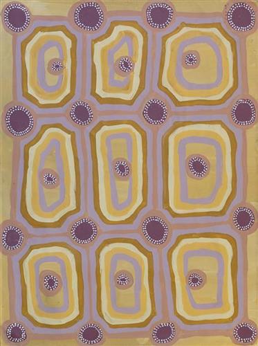
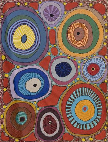
In this work Marlene depicts a waterhole and rock hole located in Mungili, the small outstation community located just off the Eagle Highway in Western Australia, approximately 430 kilometres northeast of Wiluna and 250 kilometres north of Warburton. Marlene grew up in Mungili, and as such it forms a significant part of her ‘ngurra’ (home Country, camp). Typically Marlene depicts this site with a central large circular form that represents the main waterhole, surrounded by smaller circular forms representing satellite water bodies.

During the pujiman (traditional, desert dwelling) period, knowledge of water sources was critical for survival, and today Martu Country is still defined in terms of the location and type of water. Each of the hundreds of claypans, rockholes, waterholes, soaks and springs found in the Martu desert homelands is known through real life experience and the recounting of Jukurrpa (Dreaming) narratives by name, location, quality and seasonal availability. This encyclopedic knowledge extends even to the nature and movement of arterial waterways, and sustained Martu as they travelled across their Country, hunting and gathering, visiting family, and fulfilling ceremonial obligations. They would traverse very large distances annually, visiting specific areas in the dry and wet season depending on the availability of water and the corresponding cycles of plant and animal life on which hunting and gathering bush tucker was reliant.

111582291203


Untitled

This is Kumpaya’s Country- her ‘ngurra’ (home Country, camp). People identify with their ngurra in terms of specific rights and responsibilities, and the possession of intimate knowledge of the physical and cultural properties of one’s Country. Painting ngurra, and in so doing sharing the Jukurrpa (Dreaming) stories and physical characteristics of that place, has today become an important means of cultural maintenance. 

Kumpaya’s ngurra encompasses the Country that she and her family walked in the pujiman (traditional, desert-dwelling) era. At this time she travelled nomadically with her own and other family groups, traversing an enormous tract of land around the middle section of the Canning Stock Route, and between Punmu Aboriginal community and Kiwirrkura, more than 500 kilometres eastward. 

Kumpaya was born close to Kiwirrkurra, a rockhole located in the Gibson Desert and to the south west of Lake McKay. She grew up, walked and hunted primarily around this area. As a young woman Kumpaya travelled westward, through to Kunawarritji (Canning Stock Route Well 33). She continued to live nomadically before eventually deciding to move to Jigalong Mission along with many other relatives following an extreme and prolonged drought in the 1960s. 

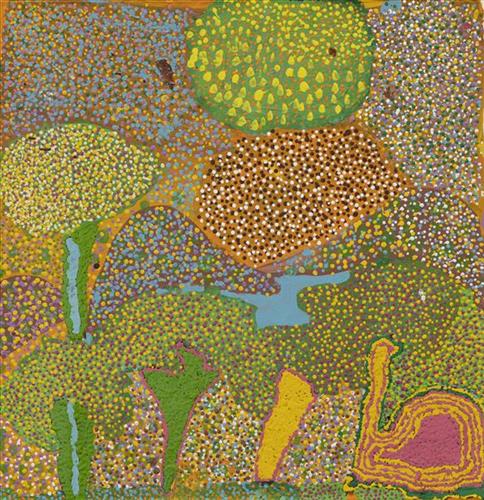
Portrayed in this work are features of Kumpaya’s ngurra, such as the striking salt lakes, dominant permanent red tali (sandhills), warta (trees, vegetation), and the individually named water sources she and her family camped at. These include Luurnkurangu, Karingkarra , Katarta, Pinkari, Pintu-pintu, Yanjiwara, Kunalimpi, Juntu-juntu (Canning Stock Route Well 30), Warla-warla (Canning Stock Route Well 31), Kunawarritji, Kinyu (Canning Stock Route Well 35), Natawalu (Canning Stock Route Well 40), and Kupankurlu. Rock holes, waterholes, soaks and springs were all extremely important sites for Martu people during the pujiman period, and are generally depicted with circular forms. 

The encyclopaedic knowledge of the location, quality and seasonal availability of the hundreds of water bodies found in one’s Country sustained Martu as they travelled across their Country, hunting and gathering, visiting family, and fulfilling ceremonial obligations. They would traverse very large distances annually, visiting specific areas in the dry and wet season depending on the availability of water and the corresponding cycles of plant and animal life on which hunting and gathering bush tucker was reliant. As they travelled and hunted they would also burn areas of Country, generating a greater diversity of plant and animal life.