111582341166


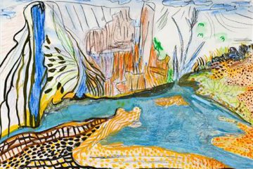
Kulyakartu

“My Country, Kulyakartu. I grew up there, from little boy to big boy grew up there.”

 – Muuki Taylor

This painting depicts Kulyakartu, Muuki’s ngurra (home Country, camp). Kulyakartu is located in the far north of the Martu homelands, near the Percival Lakes region of Western Australia’s Great Sandy Desert. Muuki has extensive knowledge of the Country in this region, where he grew up living traditionally during the pujiman (traditional, desert dwelling) days with his family. Kulyakartu is mostly grass Country where there is very good hunting. In particular parnajarrpa (goanna), wild cats, and lunki (witchetty grub) are found in abundance here. There is no permanent water source in Kulyakartu, so Muuki’s family would walk here annually following the wantajarra (wet season). During the yalijarra (hot, dry season) they would head south again to more permanent water.

Muuki paints Kulyakartu in all its different seasonal stages. Often visible in his work is the patchwork nature of regrowth subsequent to the practice of waru (fire) burning that assists with hunting, regenerates growth, and encourages greater diversity in plant and animal life. This mosaic patterning is aligned with the five distinct Martu cyclical phases of burning and regrowth. First is nyurnma (freshly burnt Country) when Muuki is “making waru”. Following nyurnma are the rains and subsequent waru-waru, when young, bright green plants start to grow. Nyukura occurs between one and three years after burning, when plants have matured and are fruiting and seeding. Manguu is “when him finished”, four to six years post burning, and when spinifex has matured to the point that it can be burned once again. Finally, kunarka signifies the time when spinifex and other plant species have become old growth, and pose a risk of destructive bushfires.

111582341165


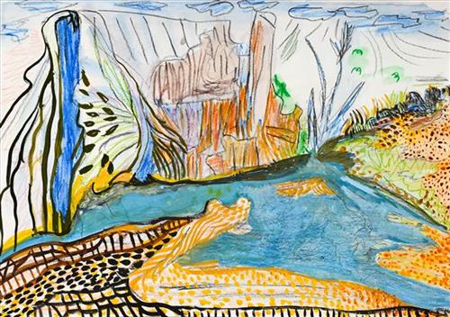
Kulyakartu

“My Country, Kulyakartu. I grew up there, from little boy to big boy grew up there.”

 – Muuki Taylor

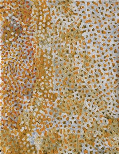
This painting depicts Kulyakartu, Muuki’s ngurra (home Country, camp). Kulyakartu is located in the far north of the Martu homelands, near the Percival Lakes region of Western Australia’s Great Sandy Desert. Muuki has extensive knowledge of the Country in this region, where he grew up living traditionally during the pujiman (traditional, desert dwelling) days with his family. Kulyakartu is mostly grass Country where there is very good hunting. In particular parnajarrpa (goanna), wild cats, and lunki (witchetty grub) are found in abundance here. There is no permanent water source in Kulyakartu, so Muuki’s family would walk here annually following the wantajarra (wet season). During the yalijarra (hot, dry season) they would head south again to more permanent water.

Muuki paints Kulyakartu in all its different seasonal stages. Often visible in his work is the patchwork nature of regrowth subsequent to the practice of waru (fire) burning that assists with hunting, regenerates growth, and encourages greater diversity in plant and animal life. This mosaic patterning is aligned with the five distinct Martu cyclical phases of burning and regrowth. First is nyurnma (freshly burnt Country) when Muuki is “making waru”. Following nyurnma are the rains and subsequent waru-waru, when young, bright green plants start to grow. Nyukura occurs between one and three years after burning, when plants have matured and are fruiting and seeding. Manguu is “when him finished”, four to six years post burning, and when spinifex has matured to the point that it can be burned once again. Finally, kunarka signifies the time when spinifex and other plant species have become old growth, and pose a risk of destructive bushfires.
111582341609


Parnngurr

“We were climbing Parnngurr hill; we were frightened. Kartiya (Europeans) would walk around, trying to catch Martu people. We would run up the hill and hide. We watched them catch people. We were eating flour that white people gave us. It was horrible. From [Parnngurr rockhole], we got in the truck and went with the white people to Jigalong. Kumpaya [Girgirba], Jakayu [Biljabu] and Ngamaru [Bidu], we were all on top of the hill looking at the white people.”

– Bugai Whyoulter


Parnngurr rockhole is located 370km east of Newman. This site lies within Bugai’s ngurra (home Country, camp), the area which she knew intimately and travelled extensively with her family in her youth. For many Martu, including Bugai, Parnngurr also signifies the location at which their nomadic bush life came to an end. Poignantly described here by Bugai, it was here that a group of 29 Martu were picked up by the Native Welfare Department to be taken to Jigalong Mission in 1963. Collectively the group had come to the decision to move to the mission as a result of an extended drought, which had caused a scarcity in food and water resources. The group also wanted to join their families, who had already moved to Jigalong.

At the junction of three linguistic groups; Manyjilyjarra, Kartujarra, and Warnman, Parnngurr rockhole was a critical and permanent source of water during the pujiman (traditional, desert born) era, supporting many ritual large gatherings. During this nomadic period families stopped and camped here depending on the seasonal availability of water and the corresponding cycles of plant and animal life on which hunting and gathering bush tucker was reliant. At Parnngurr and other similarly important camp sites families would meet for a time before moving to their next destination. Parnngurr rockhole and its surrounds are physically dominated by distinctively red tali (sandhills), covered sparingly with spinifex and low lying shrub. 

Parnngurr community, just north of Parnngurr rockhole, was created during the Return to Country movement of the 1980s, coinciding with the recognition of Aboriginal land rights and native title. The community was named after its’ original primary water source. Until recently the community was widely known as Cotton Creek, after the European name for the ephemeral creek running alongside the community.

111582341565


Spinifex

“When I went back to County, I thought how beautiful the spinifex was. How the sun glazed against the spinifex. The County that I speak of is Jilukurru, my grandfather’s country.”

– Kathleen Maree Sorenson

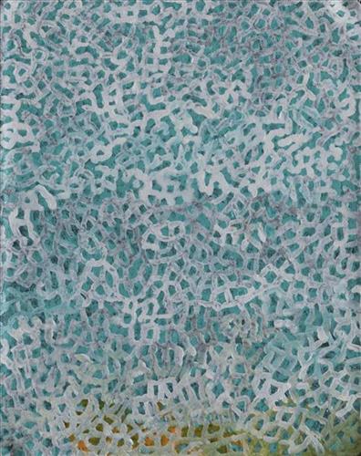
Martu Country is dominated by striking permanent tali (sandhills) covered with spinifex, gums, and other trees and shrubs. Spinifex is a pale green, spiky grass that grows in clumps throughout the Central and Western Deserts of Australia. Some varieties yield edible seeds and another contains a resin. 

111582341564


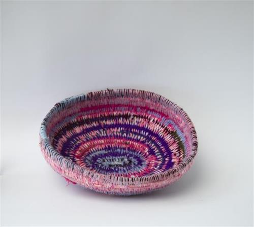
Basket

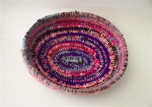
Weaving is a skill that has been practiced by Martu for thousands of years in the making of utilitarian and ceremonial items, such as yakapiri (bark sandals) and manguri (head pads for balancing carved carrying dishes). However, coiled basket weaving as an artform is a relatively newly adopted practice for the Martu, a skill passed on from Central Desert artists in the 1990’s. Leading Martu fibre arts practitioner Nola Taylor says that basket weaving was so popular amongst Martu women that it “spread across the desert like a waru (fire)”.

Each basket is built up through wrapping fine bundles of grass in brightly coloured wool and then stitching each round on to the previous one. The baskets are primarily made from puntayarra and minarri (Amphipogon Caricinus) grass, usually collected incidentally during trips to visit family, attend ceremonies, maintain Country, and hunt and gather bush tucker. Martu artists have developed a distinctive style of basketry and individual artists continue to develop new designs and incorporate novel materials, including steel, wire and wood, into their work. 

111582341561


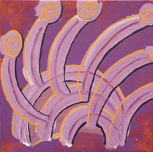
Mungili Waterholes and Rock Holes

“I was swimming there. Yeah, we go visit them a long time [ago]. We drink it, rain water from the rain. Big waterhole. It’s a fresh water, when the rain comes, fills it up. One for swimming and another rock hole for drinking.”

– Marlene Anderson

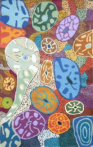
In this work Marlene depicts a waterhole and rock hole located in Mungili, the small outstation community located just off the Eagle Highway in Western Australia, approximately 430 kilometres northeast of Wiluna and 250 kilometres north of Warburton. Marlene grew up in Mungili, and as such it forms a significant part of her ‘ngurra’ (home Country, camp). Typically Marlene depicts this site with a central large circular form that represents the main waterhole, surrounded by smaller circular forms representing satellite water bodies.

During the pujiman (traditional, desert dwelling) period, knowledge of water sources was critical for survival, and today Martu Country is still defined in terms of the location and type of water. Each of the hundreds of claypans, rockholes, waterholes, soaks and springs found in the Martu desert homelands is known through real life experience and the recounting of Jukurrpa (Dreaming) narratives by name, location, quality and seasonal availability. This encyclopedic knowledge extends even to the nature and movement of arterial waterways, and sustained Martu as they travelled across their Country, hunting and gathering, visiting family, and fulfilling ceremonial obligations. They would traverse very large distances annually, visiting specific areas in the dry and wet season depending on the availability of water and the corresponding cycles of plant and animal life on which hunting and gathering bush tucker was reliant.