111582288882


Mungili Waterholes and Rock Holes

“I was swimming there. Yeah, we go visit them a long time [ago]. We drink it, rain water from the rain. Big waterhole. It’s a fresh water, when the rain comes, fills it up. One for swimming and another rock hole for drinking.”

– Marlene Anderson

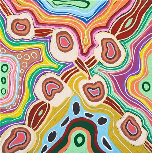
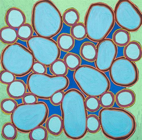
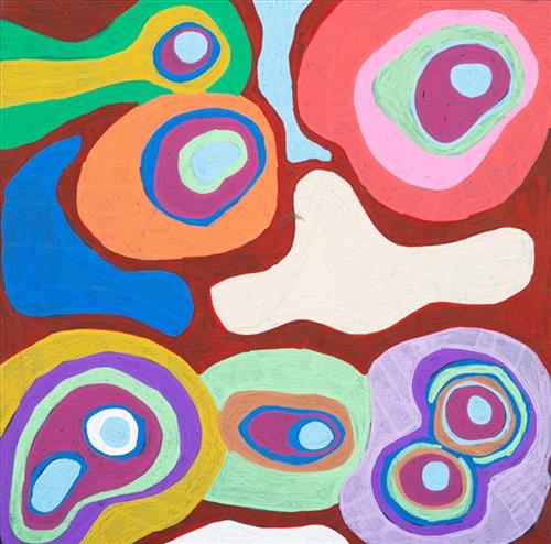
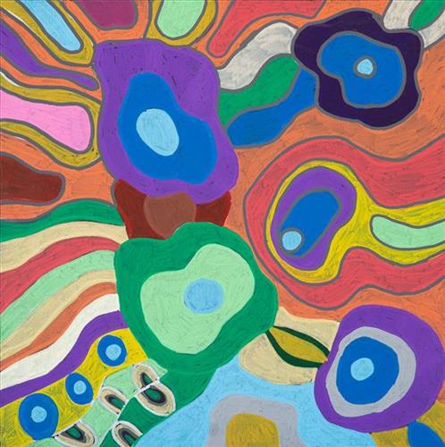
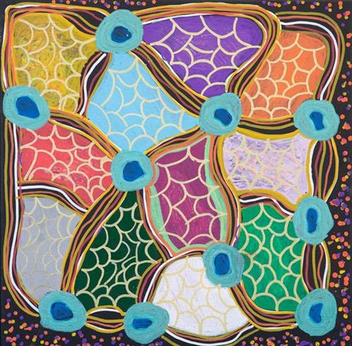
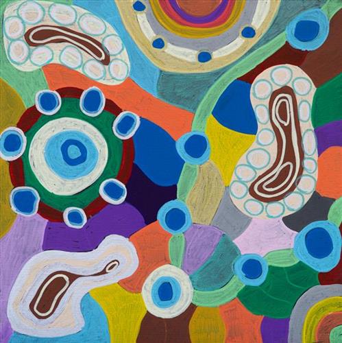
In this work Marlene depicts a waterhole and rock hole located in Mungili, the small outstation community located just off the Eagle Highway in Western Australia, approximately 430 kilometres northeast of Wiluna and 250 kilometres north of Warburton. Marlene grew up in Mungili, and as such it forms a significant part of her ‘ngurra’ (home Country, camp). Typically Marlene depicts this site with a central large circular form that represents the main waterhole, surrounded by smaller circular forms representing satellite water bodies.

During the pujiman (traditional, desert dwelling) period, knowledge of water sources was critical for survival, and today Martu Country is still defined in terms of the location and type of water. Each of the hundreds of claypans, rockholes, waterholes, soaks and springs found in the Martu desert homelands is known through real life experience and the recounting of Jukurrpa (Dreaming) narratives by name, location, quality and seasonal availability. This encyclopedic knowledge extends even to the nature and movement of arterial waterways, and sustained Martu as they travelled across their Country, hunting and gathering, visiting family, and fulfilling ceremonial obligations. They would traverse very large distances annually, visiting specific areas in the dry and wet season depending on the availability of water and the corresponding cycles of plant and animal life on which hunting and gathering bush tucker was reliant.
111582288881


Mungili Waterholes and Rock Holes

“I was swimming there. Yeah, we go visit them a long time [ago]. We drink it, rain water from the rain. Big waterhole. It’s a fresh water, when the rain comes, fills it up. One for swimming and another rock hole for drinking.”

– Marlene Anderson

In this work Marlene depicts a waterhole and rock hole located in Mungili, the small outstation community located just off the Eagle Highway in Western Australia, approximately 430 kilometres northeast of Wiluna and 250 kilometres north of Warburton. Marlene grew up in Mungili, and as such it forms a significant part of her ‘ngurra’ (home Country, camp). Typically Marlene depicts this site with a central large circular form that represents the main waterhole, surrounded by smaller circular forms representing satellite water bodies.

During the pujiman (traditional, desert dwelling) period, knowledge of water sources was critical for survival, and today Martu Country is still defined in terms of the location and type of water. Each of the hundreds of claypans, rockholes, waterholes, soaks and springs found in the Martu desert homelands is known through real life experience and the recounting of Jukurrpa (Dreaming) narratives by name, location, quality and seasonal availability. This encyclopedic knowledge extends even to the nature and movement of arterial waterways, and sustained Martu as they travelled across their Country, hunting and gathering, visiting family, and fulfilling ceremonial obligations. They would traverse very large distances annually, visiting specific areas in the dry and wet season depending on the availability of water and the corresponding cycles of plant and animal life on which hunting and gathering bush tucker was reliant.
111582288880


Mungili Waterholes and Rock Holes

“I was swimming there. Yeah, we go visit them a long time [ago]. We drink it, rain water from the rain. Big waterhole. It’s a fresh water, when the rain comes, fills it up. One for swimming and another rock hole for drinking.”

– Marlene Anderson

In this work Marlene depicts a waterhole and rock hole located in Mungili, the small outstation community located just off the Eagle Highway in Western Australia, approximately 430 kilometres northeast of Wiluna and 250 kilometres north of Warburton. Marlene grew up in Mungili, and as such it forms a significant part of her ‘ngurra’ (home Country, camp). Typically Marlene depicts this site with a central large circular form that represents the main waterhole, surrounded by smaller circular forms representing satellite water bodies.

During the pujiman (traditional, desert dwelling) period, knowledge of water sources was critical for survival, and today Martu Country is still defined in terms of the location and type of water. Each of the hundreds of claypans, rockholes, waterholes, soaks and springs found in the Martu desert homelands is known through real life experience and the recounting of Jukurrpa (Dreaming) narratives by name, location, quality and seasonal availability. This encyclopedic knowledge extends even to the nature and movement of arterial waterways, and sustained Martu as they travelled across their Country, hunting and gathering, visiting family, and fulfilling ceremonial obligations. They would traverse very large distances annually, visiting specific areas in the dry and wet season depending on the availability of water and the corresponding cycles of plant and animal life on which hunting and gathering bush tucker was reliant.
111582288879


Mungili Waterholes and Rock Holes

“I was swimming there. Yeah, we go visit them a long time [ago]. We drink it, rain water from the rain. Big waterhole. It’s a fresh water, when the rain comes, fills it up. One for swimming and another rock hole for drinking.”

– Marlene Anderson

In this work Marlene depicts a waterhole and rock hole located in Mungili, the small outstation community located just off the Eagle Highway in Western Australia, approximately 430 kilometres northeast of Wiluna and 250 kilometres north of Warburton. Marlene grew up in Mungili, and as such it forms a significant part of her ‘ngurra’ (home Country, camp). Typically Marlene depicts this site with a central large circular form that represents the main waterhole, surrounded by smaller circular forms representing satellite water bodies.

During the pujiman (traditional, desert dwelling) period, knowledge of water sources was critical for survival, and today Martu Country is still defined in terms of the location and type of water. Each of the hundreds of claypans, rockholes, waterholes, soaks and springs found in the Martu desert homelands is known through real life experience and the recounting of Jukurrpa (Dreaming) narratives by name, location, quality and seasonal availability. This encyclopedic knowledge extends even to the nature and movement of arterial waterways, and sustained Martu as they travelled across their Country, hunting and gathering, visiting family, and fulfilling ceremonial obligations. They would traverse very large distances annually, visiting specific areas in the dry and wet season depending on the availability of water and the corresponding cycles of plant and animal life on which hunting and gathering bush tucker was reliant.
111582288877


Kun Kun (Kuny-Kuny)

Kun Kun (Kuny-kuny) is a soak accessing a large body of underground water, located southeast of Kunawarritji (Canning Stock Route Well 33). The site is sacred for its association with the marlu (kangaroo) Jukurrpa (Dreaming), and was an important ceremonial site during the pujiman (traditional, desert dwelling) period.

At this time, Martu would traverse very large distances annually in small family groups, moving seasonally from water source to water source, and hunting and gathering bush tucker as they went. Knowledge of water sources was critical for survival, and today Martu Country is still defined in terms of the location and type of water. Each of the hundreds of claypans, rockholes, waterholes, soaks and springs found in the Martu desert homelands is known by name, location, quality and seasonal availability through real life experience and the recounting of Jukurrpa narratives.

Soaks, or soakwaters, derive their name from the manner in which their waters generally seep into the sand from below stores, sometimes as part of an ephemeral river or creek. Soaks were an especially important source of water during the pujiman era, being the most dependable water source in times of drought. Water was obtained from soaks by scooping away the sand with a piti (timber bowls used for carrying food and water) until clear water gathered at the base of the hole, sometimes at a depth of several metres.

111582288876


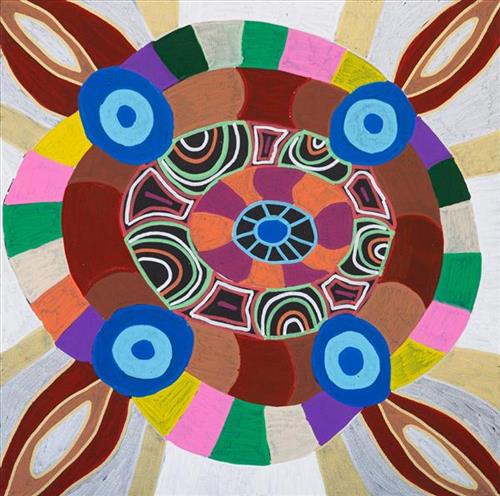
Mungili Waterholes and Rock Holes

“I was swimming there. Yeah, we go visit them a long time [ago]. We drink it, rain water from the rain. Big waterhole. It’s a fresh water, when the rain comes, fills it up. One for swimming and another rock hole for drinking.”

– Marlene Anderson

In this work Marlene depicts a waterhole and rock hole located in Mungili, the small outstation community located just off the Eagle Highway in Western Australia, approximately 430 kilometres northeast of Wiluna and 250 kilometres north of Warburton. Marlene grew up in Mungili, and as such it forms a significant part of her ‘ngurra’ (home Country, camp). Typically Marlene depicts this site with a central large circular form that represents the main waterhole, surrounded by smaller circular forms representing satellite water bodies.

During the pujiman (traditional, desert dwelling) period, knowledge of water sources was critical for survival, and today Martu Country is still defined in terms of the location and type of water. Each of the hundreds of claypans, rockholes, waterholes, soaks and springs found in the Martu desert homelands is known through real life experience and the recounting of Jukurrpa (Dreaming) narratives by name, location, quality and seasonal availability. This encyclopedic knowledge extends even to the nature and movement of arterial waterways, and sustained Martu as they travelled across their Country, hunting and gathering, visiting family, and fulfilling ceremonial obligations. They would traverse very large distances annually, visiting specific areas in the dry and wet season depending on the availability of water and the corresponding cycles of plant and animal life on which hunting and gathering bush tucker was reliant.
111582288874


Kun Kun (Kuny-Kuny)

Kun Kun (Kuny-kuny) is a soak accessing a large body of underground water, located southeast of Kunawarritji (Canning Stock Route Well 33). The site is sacred for its association with the marlu (kangaroo) Jukurrpa (Dreaming), and was an important ceremonial site during the pujiman (traditional, desert dwelling) period.

At this time, Martu would traverse very large distances annually in small family groups, moving seasonally from water source to water source, and hunting and gathering bush tucker as they went. Knowledge of water sources was critical for survival, and today Martu Country is still defined in terms of the location and type of water. Each of the hundreds of claypans, rockholes, waterholes, soaks and springs found in the Martu desert homelands is known by name, location, quality and seasonal availability through real life experience and the recounting of Jukurrpa narratives.

Soaks, or soakwaters, derive their name from the manner in which their waters generally seep into the sand from below stores, sometimes as part of an ephemeral river or creek. Soaks were an especially important source of water during the pujiman era, being the most dependable water source in times of drought. Water was obtained from soaks by scooping away the sand with a piti (timber bowls used for carrying food and water) until clear water gathered at the base of the hole, sometimes at a depth of several metres.

111982288868


Warraburnburn

In Burarra and Gun-nartpa languages the figure represented in this artwork is generally known as a wangarra ‘ghost spirit’. For the Warrawarra clan ghost spirits have their own particular characteristics and their own name – Warraburnburn.

The Warraburnburn and the closely related Galabarrbarr spirit (owned by the Balkarranga clan) are also manikay song topics.  The spirits are related to each other as maternal grandparent and grandchild, just as the people of Warrawarra and Balkarranga are. The dancing of the two ghost spirit figures forms the finale performance for funerals, and is the final goodbye to a deceased family member.

In many ways the Warraburnburn and Galabarrbarr ghost spirits are like people. They emerge from the patches of jungle on Warrawarra and Balkarranga country in the late afternoon and go hunting in family groups of men, women and children. They stay in contact with each other by calling out as the men hunt for fish and the women walk with their dillybags looking for vegetable food. 

The ghost spirits are associated closely with white ochre and artists commonly paint the bodies of carved figures in white. Different types of ghost spirit wear different patterns. Warraburnburn is decorated with uniform white dots while others are painted white all over. Some ghost spirits are shown with a design painted on their chest infilled with rarrk ‘cross-hatching’, the same designs that are painted onto japi an-guyinda ‘male initiations’. 

They also have supernatural characteristics including superhuman size (jarra anbaykarda ‘super tall’). They know the country intimately – some are malevolent towards humans and will lead people astray, taking them to unfamiliar and dangerous places. These malevolent spirits are likened to an-muburda ‘sorcerers’ and can conduct dangerous rituals that cause harm to people. Others are benign and will lead humans back to familiar paths and their own camps.


111982288867


Yawkyawk

Yawkyawk is a word in the Kunwinjku/Kunwok language of Western Arnhem Land meaning ‘young woman’ and ‘young woman spirit being’. The different groups of Kunwinjku people (one of the Eastern dialect groups call themselves Kuninjku) each have Yawkyawk mythologies, which relate to specific locations in clan estates. These mythologies are represented in bark paintings and sculptures of Yawkyawk beings. There are also a few examples of rock art images of these beings.
The female water spirits Yawkyawk or Ngalkunburriyaymi are perhaps the most enigmatic of mythological themes. Sometimes compared to the European notion of mermaids, they exist as spiritual beings living in freshwater streams and rock pools, particularly those in the stone country. The spirit Yawkyawk is usually described and depicted with the tail of a fish. Thus the Kuninjku people sometimes call them ngalberddjenj which literally means ‘the young woman who has a tail like a fish’. They have long hair, which is associated with trailing blooms of green algae (called man-bak in Kuninjku). At times they leave their aquatic homes to walk about on dry land, particularly at night.
Aboriginal people believe that in the beginning most animals were humans. During the time of the creation of landscapes and plants and animals, these ancestral heroes in human form transmutated into their animal forms via a series of various significant events now recorded as oral mythologies. The creation ancestor Yawkyawk travelled the country in human form and changed into the form of Ngalkunburriyaymi as a result of various ancestral adventures. Today the Kuninjku believe that Ngalkunburriyaymi are alive and well and living in freshwater sites in a number of sacred locations.
Some features of a respective country are equated with body parts of Yawkyawk. For example a bend in a river or creek may be said to be ‘the tail of the Yawkyawk, a billabong may be ‘the head of the Yawkyawk and so on. Thus different groups can be linked together by means of a shared mythology featured in the landscape, which crosscuts clan and language group boundaries.

111982288866


Yawkyawk

Yawkyawk is a word in the Kunwinjku/Kunwok language of Western Arnhem Land meaning ‘young woman’ and ‘young woman spirit being’. The different groups of Kunwinjku people (one of the Eastern dialect groups call themselves Kuninjku) each have Yawkyawk mythologies, which relate to specific locations in clan estates. These mythologies are represented in bark paintings and sculptures of Yawkyawk beings. There are also a few examples of rock art images of these beings.
The female water spirits Yawkyawk or Ngalkunburriyaymi are perhaps the most enigmatic of mythological themes. Sometimes compared to the European notion of mermaids, they exist as spiritual beings living in freshwater streams and rock pools, particularly those in the stone country. The spirit Yawkyawk is usually described and depicted with the tail of a fish. Thus the Kuninjku people sometimes call them ngalberddjenj which literally means ‘the young woman who has a tail like a fish’. They have long hair, which is associated with trailing blooms of green algae (called man-bak in Kuninjku). At times they leave their aquatic homes to walk about on dry land, particularly at night.
Aboriginal people believe that in the beginning most animals were humans. During the time of the creation of landscapes and plants and animals, these ancestral heroes in human form transmutated into their animal forms via a series of various significant events now recorded as oral mythologies. The creation ancestor Yawkyawk travelled the country in human form and changed into the form of Ngalkunburriyaymi as a result of various ancestral adventures. Today the Kuninjku believe that Ngalkunburriyaymi are alive and well and living in freshwater sites in a number of sacred locations.
Some features of a respective country are equated with body parts of Yawkyawk. For example a bend in a river or creek may be said to be ‘the tail of the Yawkyawk, a billabong may be ‘the head of the Yawkyawk and so on. Thus different groups can be linked together by means of a shared mythology featured in the landscape, which crosscuts clan and language group boundaries.