111982241860


Mako (didjeridu)

Arnhem Land and the Top End of the Northern Territory is the traditional home of the didjeridu, a rhythmic wind instrument used by Aboriginal people of the region. Its use spread globally in part because the instrument was adopted by world music enthusiasts, and the profile of the instrument reached new heights through Aboriginal rock bands from Arnhem Land, such as Yothu Yindi. It’s an instrument that is now played around the world, in genres ranging from classical to hip hop.

The didjeridu has come to mean many different things to people who have a reason for playing it around the world. In Maningrida it remains primarily an instrument of song accompaniment used in public ceremony. The manner of playing provides an instant recognition to listeners of both language and regional stylistic affiliation. In the wake of the development of new non-Aboriginal ‘world’ styles of playing the instrument, Arnhem Land styles of playing take on new meaning as markers of the cultural and historical origins of the didjeridu.

All of the language groups of the Maningrida region have their own musical genres and song series in which the didjeridu is used as an instrument of accompaniment. Traditionally, it is primarily a secular instrument used in song genres that are performed for two main types of public ceremony: the music of diplomacy (exchange) ceremonies and of funerals and some mortuary rituals. The didjeridu is generally not used as a solo instrument and nor is it used in the most secret and sacred ceremonies still practiced in the western and central Arnhem Land region.

Aboriginal people living today in the rocky escarpment country of western Arnhem Land say that humans were first shown and taught to play the didjeridu by spirit beings who live among the dark caves and crevices of the stone country. These beings are known as mimih and are said to be tall and slender with necks so fragile they are easily snapped by the gentlest of breezes. Because of this, mimih live inside their own worlds within the rock. Mimih are credited with teaching Aboriginal people of the stone country about the foundations of stone country culture, including how to play the didjeridu. Many of the stone country language groups today describe their song and dance genres as mimih.

Researchers of Arnhem Land rock art have identified depictions of the didjeridu as belonging to the most recent phase of rock art, commencing around 1500 years ago.

Aboriginal names

Maningrida is a highly multilingual community and the linguistic diversity of western Arnhem Land is reflected in the various names used for the didjeridu. Here are the names for the instrument in the languages of the Maningrida region:

  • Ndjébbana (the language of the Kunibídji people) – ngalidjbinja
  • Kunwinjku, Kune, Kuninjku – mako [mago]
  • Rembarrnga – liddung, djalubbu
  • Burarra, Gun-nartpa – ngorla
  • Dangbon, Dalabon – morlo
  • Djinang, Wurlaki – wuyimbarl
  • Nakkara – ngunebobanja
  • Gurrgoni – mudburuja
  • Gundjeihmi (and also Kune) – morle

Process

The didjeridu-maker looks through bushland for a tree of the right species with the right diameter trunk. Most didjeridus in the Maningrida region are made from young trunks of the stringybark tree (Eucalyptus tetradonta) or the Darwin Woollybutt (Eucalyptus miniata).

The trunk needs to have been lived in and hollowed out by termites. To listen for hollowness, a tree with potential is stripped of a small patch of bark and the timber is tapped. The sound produced indicates the quality of the instrument the trunk will become. Having selected a good tree, the artist fells it and cleans out the hollow inside of the trunk, usually by ramming out any termite debris with a stick or pole. He strips all the bark off the outside, and smooths both ends. Traditionally, dark wax resin (cerumen or, in Kunwinjku and Rembarrnga languages, birdi) from native bees is applied to the mouthpiece. This substance sets hard but always becomes soft and pliable under pressure, enabling an airtight seal when playing.

Styles

In the Maningrida region, didjeridus are made to accompany songs in either of two styles: the bunggurl style of the language groups of eastern Arnhem Land (such as Bararra) or the kun-borrk style of language groups in the west of Arnhem Land (including Kunwinjku). People of central and south-western Arnhem Land whose country borders east and west (Rembarrnga and Kune), perform both styles.

Didjeridus of the region range in length from just under one metre to two metres. A less flared and longer didjeridu (1.5–2m) makes it easier to produce the characteristic hooted overblown tone that is used in bunggurl-style music. Longer didjeridus have a deeper tone than shorter didjeridus, and more resonance. To play them, you vibrate your lips at a lower frequency than you need to for a shorter didjeridu.

The decoration applied to the instrument can indicate its intended use. Rembarrnga artist Bob Burruwal often uses a design called bedjekbedjek. This is the same design used in body painting for the public diplomacy ceremonies of the Rembarrnga (and many other kun-borrk dance performances). Burruwal slaps wet white ochre over the surface of the instrument with his hands or with a bunch of leaves dipped in the ochre.
 

115682241671


Ngambi (limestone spearheads)

This painting illustrates elements from the Wagilag Sisters’ Creation story.  Ngambi are the stone spear heads that the sisters collected at Ngilipitji on their way to Mirarrmina.

The Wagilag Sisters’ Story is primarily an account of how in the distant past the two Wagilag Sisters came out of the southern interior and came across the countryside to the Liyagalawumirr waterhole at Mirarrmina. There the younger sister profaned the pool of the great Python by accidently allowing her  blood to fall into the waterhole. Because of this the women and the children were swallowed by the Olive Python, Wititj, along with all the water from the waterhole. The other snakes heard about this and demanded Wititj spit out the sisters. Wititj vomited the women out, along with the water, creating the first monsoon rains.

115682241670


Arafura Palm

With its massive trunk it is one of Australia’s most imposing palms and it has a spectacular single display of flowering and fruiting before dying.

This is part of JB’s Dhuwa moiety

115682241669


Woven Mat

Traditionally, Nganiyal (conical mats) were used as an insect screen when erected, and as a sitting mat when folded. They are used in Ceremony as well as a functional item. 

Nowadays, artists weave many different shapes including flat, round and oblong. 

115682241667


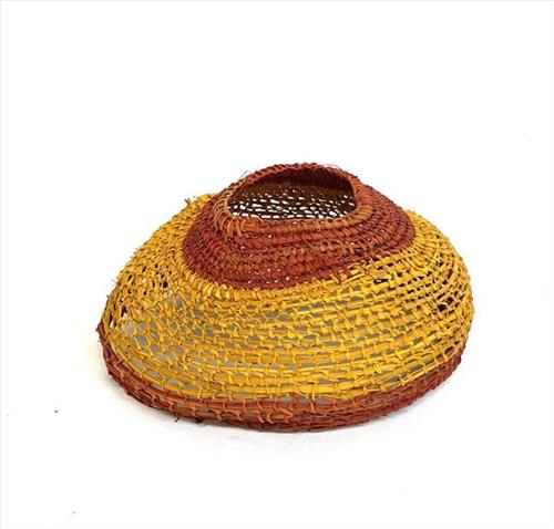
Mindirr (Pandanus Bag)

Miṉḏirr (dilly bags) are made from gunga (Pandanus spiralis), baḻgurr (kurrajong) and natural bush dyes. The body of the miṉḏirr is made from gunga, and the handles from baḻgurr. Once the gunga fronds and baḻgurr bark have been collected, they are stripped and prepared then boiled with the dyes.

Miṉḏirr were used traditionally for every day utilitarian purposes, particularly collecting bush foods such as bäḻtji (yam). Traditionally, the baḻgurr handles were worn across the forehead while the body of the miṉḏirr sat at the back, between the shoulder blades making it easily accessible when collecting ŋatha (food).

111582241694


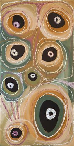
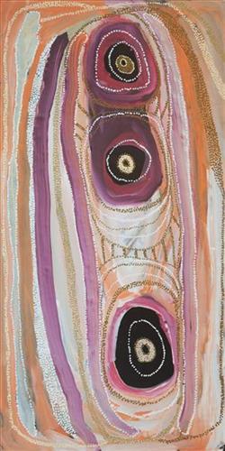
Kaalpa (Kalypa, Canning Stock Route Well 23)

“Kaalpa (Kalypa, Canning Stock Route Well 23) is my grandfather’s Country. There’s a waterhole there, Kaalpa waterhole. It’s my two pops’ Country. They been walking around, hunting around Kaalpa. You can see a yapu (rock), warla (lake), claypans, karru (creek) and tuwa (sandhills) there. It’s on the [Canning] Stock Route, it’s Well 23.  

In pujiman (traditional, desert dwelling) days, pujimanpa (desert born people) walking around all this Country. My pops told me about that place, a big flat area, parlkarra (flat country) good for hunting parnajarrpa (goanna), lunki (witchetty grub), lungkurta (blue tongue lizard), wamurla (bush tomato), jinyjiwirrilyi (wild gooseberry). Kaalpa is a busy place for emus getting a drink. 

I went [to Kaalpa] for the first time [in 2018] on a Martumili KJ [Kanyirninpa Jukurrpa] trip. I went hunting there, got a parnajarrpa. When I went there, I was pukurlpa (happy). It made you open up your spirit, it feels like home.”

 – Corban Clause Williams

Kaalpa is a permanent water source located northeast of Kumpupirntily (Kumpupintily, Lake Disappointment). This site is a place of great cultural significance, and is also known for good hunting. Adjacent to the waterhole is a hill of the same name. The landscape around Kaalpa is parlkarra (flat country), bordered by tali (sandhills) stretching as far as Windy Corner, northeast and towards the border of Western Australia and the Northern Territory. The large and dangerous Jukurrpa (Dreamtime) mosquito and fly beings partially created the landforms in this area and continue to live underground here.

Kaalpa also features in the Minyipuru (Jakulyukulyu, Seven Sisters) Jukurrpa, a central creation narrative for Martu, Ngaanyatjarra, Pitjantjatjara and Yankunytjatjara people that is associated with the seasonal Pleiades star constellation. At Kaalpa the Minyipuru met a group of men; it was the first time either group had seen members of the opposite sex. The men tried to grab the women, but the Minyipuru chased them, hitting them with their digging sticks and leaving them lying there as they continued travelling east.

Relayed in song, dance, stories and paintings, Minyipuru serves as a creation narrative, a source of information relating to the physical properties of the land, and an embodiment of Aboriginal cultural laws. Beginning in Roebourne on the west coast of Western Australia, the story morphs in its movement eastward across the land, following the women as they walk, dance, and even fly from waterhole to waterhole. As they travel the women camp, sing, wash, dance and gather food, leaving markers in the landscape and creating landforms that remain to this day, such as groupings of rocks and trees, grinding stones and seeds. During the entirety of their journey the women are pursued by a lustful old man, Yurla, although interactions with other animals, groups of men, and spirit beings are also chronicled in the narrative.

The intersection of the Canning Stock Route with Kaalpa also made this a site of early contact with Europeans for many Martu then living a pujiman life in the desert. Following the route’s construction, Martu encountered Europeans and other Martu working as cattle drovers as they would travel up and down the Stock Route from water source to water source. Increasingly, pujimanpa followed the route to newly established ration depots, mission and pastoral stations. They were drawn to the route in search of food, by a sense of curiosity, or by loneliness. By the late 1950s and early 1960s, most of the desert family groups had left the desert. Eventually, these factors combined with an extreme and prolonged drought in the 1960s to prompt the few remaining pujimanpa to move in from the desert.

111582241696


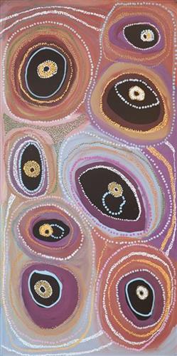
Kaalpa (Kalypa, Canning Stock Route Well 23)- Corban Clause Williams

“Kaalpa (Kalypa, Canning Stock Route Well 23) is my grandfather’s Country. There’s a waterhole there, Kaalpa waterhole. It’s my two pops’ Country. They been walking around, hunting around Kaalpa. You can see a yapu (rock), warla (lake), claypans, karru (creek) and tuwa (sandhills) there. It’s on the [Canning] Stock Route, it’s Well 23.  

In pujiman (traditional, desert dwelling) days, pujimanpa (desert born people) walking around all this Country. My pops told me about that place, a big flat area, parlkarra (flat country) good for hunting parnajarrpa (goanna), lunki (witchetty grub), lungkurta (blue tongue lizard), wamurla (bush tomato), jinyjiwirrilyi (wild gooseberry). Kaalpa is a busy place for emus getting a drink. 

I went [to Kaalpa] for the first time [in 2018] on a Martumili KJ [Kanyirninpa Jukurrpa] trip. I went hunting there, got a parnajarrpa. When I went there, I was pukurlpa (happy). It made you open up your spirit, it feels like home.”

 – Corban Clause Williams

Kaalpa is a permanent water source located northeast of Kumpupirntily (Kumpupintily, Lake Disappointment). This site is a place of great cultural significance, and is also known for good hunting. Adjacent to the waterhole is a hill of the same name. The landscape around Kaalpa is parlkarra (flat country), bordered by tali (sandhills) stretching as far as Windy Corner, northeast and towards the border of Western Australia and the Northern Territory. The large and dangerous Jukurrpa (Dreamtime) mosquito and fly beings partially created the landforms in this area and continue to live underground here.

Kaalpa also features in the Minyipuru (Jakulyukulyu, Seven Sisters) Jukurrpa, a central creation narrative for Martu, Ngaanyatjarra, Pitjantjatjara and Yankunytjatjara people that is associated with the seasonal Pleiades star constellation. At Kaalpa the Minyipuru met a group of men; it was the first time either group had seen members of the opposite sex. The men tried to grab the women, but the Minyipuru chased them, hitting them with their digging sticks and leaving them lying there as they continued travelling east.

Relayed in song, dance, stories and paintings, Minyipuru serves as a creation narrative, a source of information relating to the physical properties of the land, and an embodiment of Aboriginal cultural laws. Beginning in Roebourne on the west coast of Western Australia, the story morphs in its movement eastward across the land, following the women as they walk, dance, and even fly from waterhole to waterhole. As they travel the women camp, sing, wash, dance and gather food, leaving markers in the landscape and creating landforms that remain to this day, such as groupings of rocks and trees, grinding stones and seeds. During the entirety of their journey the women are pursued by a lustful old man, Yurla, although interactions with other animals, groups of men, and spirit beings are also chronicled in the narrative.

The intersection of the Canning Stock Route with Kaalpa also made this a site of early contact with Europeans for many Martu then living a pujiman life in the desert. Following the route’s construction, Martu encountered Europeans and other Martu working as cattle drovers as they would travel up and down the Stock Route from water source to water source. Increasingly, pujimanpa followed the route to newly established ration depots, mission and pastoral stations. They were drawn to the route in search of food, by a sense of curiosity, or by loneliness. By the late 1950s and early 1960s, most of the desert family groups had left the desert. Eventually, these factors combined with an extreme and prolonged drought in the 1960s to prompt the few remaining pujimanpa to move in from the desert.

111582241695


Kaalpa (Kalypa, Canning Stock Route Well 23)

“Kaalpa (Kalypa, Canning Stock Route Well 23) is my grandfather’s Country. There’s a waterhole there, Kaalpa waterhole. It’s my two pops’ Country. They been walking around, hunting around Kaalpa. You can see a yapu (rock), warla (lake), claypans, karru (creek) and tuwa (sandhills) there. It’s on the [Canning] Stock Route, it’s Well 23.  

In pujiman (traditional, desert dwelling) days, pujimanpa (desert born people) walking around all this Country. My pops told me about that place, a big flat area, parlkarra (flat country) good for hunting parnajarrpa (goanna), lunki (witchetty grub), lungkurta (blue tongue lizard), wamurla (bush tomato), jinyjiwirrilyi (wild gooseberry). Kaalpa is a busy place for emus getting a drink. 

I went [to Kaalpa] for the first time [in 2018] on a Martumili KJ [Kanyirninpa Jukurrpa] trip. I went hunting there, got a parnajarrpa. When I went there, I was pukurlpa (happy). It made you open up your spirit, it feels like home.”

 – Corban Clause Williams

Kaalpa is a permanent water source located northeast of Kumpupirntily (Kumpupintily, Lake Disappointment). This site is a place of great cultural significance, and is also known for good hunting. Adjacent to the waterhole is a hill of the same name. The landscape around Kaalpa is parlkarra (flat country), bordered by tali (sandhills) stretching as far as Windy Corner, northeast and towards the border of Western Australia and the Northern Territory. The large and dangerous Jukurrpa (Dreamtime) mosquito and fly beings partially created the landforms in this area and continue to live underground here.

Kaalpa also features in the Minyipuru (Jakulyukulyu, Seven Sisters) Jukurrpa, a central creation narrative for Martu, Ngaanyatjarra, Pitjantjatjara and Yankunytjatjara people that is associated with the seasonal Pleiades star constellation. At Kaalpa the Minyipuru met a group of men; it was the first time either group had seen members of the opposite sex. The men tried to grab the women, but the Minyipuru chased them, hitting them with their digging sticks and leaving them lying there as they continued travelling east.

Relayed in song, dance, stories and paintings, Minyipuru serves as a creation narrative, a source of information relating to the physical properties of the land, and an embodiment of Aboriginal cultural laws. Beginning in Roebourne on the west coast of Western Australia, the story morphs in its movement eastward across the land, following the women as they walk, dance, and even fly from waterhole to waterhole. As they travel the women camp, sing, wash, dance and gather food, leaving markers in the landscape and creating landforms that remain to this day, such as groupings of rocks and trees, grinding stones and seeds. During the entirety of their journey the women are pursued by a lustful old man, Yurla, although interactions with other animals, groups of men, and spirit beings are also chronicled in the narrative.

The intersection of the Canning Stock Route with Kaalpa also made this a site of early contact with Europeans for many Martu then living a pujiman life in the desert. Following the route’s construction, Martu encountered Europeans and other Martu working as cattle drovers as they would travel up and down the Stock Route from water source to water source. Increasingly, pujimanpa followed the route to newly established ration depots, mission and pastoral stations. They were drawn to the route in search of food, by a sense of curiosity, or by loneliness. By the late 1950s and early 1960s, most of the desert family groups had left the desert. Eventually, these factors combined with an extreme and prolonged drought in the 1960s to prompt the few remaining pujimanpa to move in from the desert.