Tuwa around Kunawarritji
Pija was born in the desert, near Kunawarritji Community (also known as Well 33 on the Canning Stock Route). This artwork illustrates the sandhills and the vegetation that grows in the desert around Kunawarritji.


Pija was born in the desert, near Kunawarritji Community (also known as Well 33 on the Canning Stock Route). This artwork illustrates the sandhills and the vegetation that grows in the desert around Kunawarritji.


This painting represents an area in Bugai’s ngurra (home country), where she lived and travelled extensively throughout the pujiman (nomadic bush) era with her family. She travelled from what is now Balfour Downs Station, where she was born, all around the Parnngurr area and up and down the Canning Stock Route as far as Kunawarritji. Kunawarritji is also known as well 33 and is now her home community. Bugai has extensive knowledge of this large tract of land, and loves to paint and tell the stories for her country.
Depicted are physical elements of Martu Country, such as the dominant tali (sandhills), warta (trees, vegetation), and water sources. Rock holes, waterholes, soaks and springs were all extremely important sites for Martu people during the pujiman period, with many important jukurrpa (dreamtime stories) chronicling the creation of these landmarks. In the past the Martu lived nomadically, moving from water source to water source, and hunting and gathering bush tucker as they went. They would traverse very large distances annually, visiting specific areas in the dry and wet season depending on the availability of water. As they travelled and hunted they would also burn areas of country creating a larger diversity of plant and animal life.

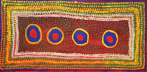
This is Pukina’s Country- his ‘ngurra’ (home Country, camp). People identify with their ngurra in terms of specific rights and responsibilities, and the possession of intimate knowledge of the physical and cultural properties of one’s Country. Painting ngurra, and in so doing sharing the Jukurrpa (Dreaming) stories and physical characteristics of that place, has today become an important means of cultural maintenance. Pukina’s ngurra encompasses the Country to the North and East of Kunawarritji (Canning Stock Route Well 33), where he and his family walked during the pujiman (traditional, desert dwelling) era.
Portrayed in this work are features of Pukina’s ngurra, such as the striking salt lakes, permanent red tali (sandhills), warta (trees, vegetation), and the individually named water sources he camped at with his extended family. These include Nyukuwarta, Jamparri, Matakurlu, Marlakajarra, Jilankujarra, Nyunturru, Yunapayi, Kun Kun (Kuny-kuny), Parlkarraparlkarr, and Wakalpuka. Rock holes, waterholes, soaks and springs were all extremely important sites for Martu people during the pujiman period, and are generally depicted with circular forms.
The encyclopaedic knowledge of the location, quality and seasonal availability of the hundreds of water bodies found in one’s Country sustained Martu as they travelled across their Country, hunting and gathering, visiting family, and fulfilling ceremonial obligations. They would traverse very large distances annually, visiting specific areas in the dry and wet season depending on the availability of water and the corresponding cycles of plant and animal life on which hunting and gathering bush tucker was reliant. As they travelled and hunted they would also burn areas of Country, generating a greater diversity of plant and animal life.


This painting depicts Blue Hills, which is Miriam’s father’s ancestral country. Kajarra (Kadjara) is the Martu name for the Carnarvon Ranges, which are situated in the Little Sandy Desert around 50 kilometres west of Well 5 on the Canning Stock Route. The red granite battlements of Kadjara rise up from spinifex plains and have many permanent waters. Kadjara was an important camping place for Martu walking between Jigalong and Wiluna for Law business up until the late 1960s, as well as Martu who walked the Canning Stock Route into Wiluna. Kadjara can be seen from Blue Hills. Blue Hills, now abandoned, was a small Martu outstation running cattle established after World War II and famously run by Tommy Ingebong, a Putijarra Martu from Wiluna. Many Martu people know of Blue Hills because of its was one of the first land grants to Martu, and because of its stunning views north-west across to Kajarra. Kajarra was the site of the 2008 Birriliburru Native Title Determination.


This is Pinyirr’s Country- her ‘ngurra’ (home Country, camp). People identify with their ngurra in terms of specific rights and responsibilities, and the possession of intimate knowledge of the physical and cultural properties of one’s Country. Painting ngurra, and in so doing sharing the Jukurrpa (Dreaming) stories and physical characteristics of that place, has today become an important means of cultural maintenance.
Pinyirr’s ngurra encompasses the Country that she and her family walked in the pujiman (traditional, desert dwelling) era. At this time Pinyirr travelled nomadically with her own and other family groups, most notably the Bidu family. The Country they traversed encompassed an enormous tract of land, with an aerial distance of more than 600 kilometres, from present day Balfour Downs Station to Kunawarritji (Canning Stock Route Well 33). Pinyirr was born at Jartuti, a soak and claypan located southeast of Martilirri (Canning Stock Route Well 22). She grew up, walked and hunted primarily around Parnngurr, Punmu, Kun Kun (Kuny-kuny) and Kunawarritji. She continued to live nomadically before eventually deciding to move to Jigalong Mission along with many other relatives following an extreme and prolonged drought in the 1960s.
Portrayed in this work are features of Pinyirr’s ngurra, such as the striking salt lakes, dominant permanent red tali (sandhills), warta (trees, vegetation), and the individually named water sources Pinyirr and her family camped at. These include Parnngurr, Martilirri, Wangkakalu, Kurta-kurta (Camel Rock), Pimurlu, Jilkupuka (Canning Stock Route Well 21), Kaalpa (Canning Stock Route Well 23), Kartarru (Canning Stock Route Well 24), Wantili (Warntili, Canning Stock Route Well 25), Tiwa (Canning Stock Route Well 26), Partujarrapirri, Raarki (Canning Stock Route Well 27), Wuranu (Canning Stock Route Well 29), Juntu- juntu (Canning Stock Route Well 30), and Kunawarritji. Rock holes, waterholes, soaks and springs were all extremely important sites for Martu people during the pujiman period, and are generally depicted with circular forms.
The encyclopaedic knowledge of the location, quality and seasonal availability of the hundreds of water bodies found in one’s Country sustained Martu as they travelled across their Country, hunting and gathering, visiting family, and fulfilling ceremonial obligations. They would traverse very large distances annually, visiting specific areas in the dry and wet season depending on the availability of water and the corresponding cycles of plant and animal life on which hunting and gathering bush tucker was reliant. As they travelled and hunted they would also burn areas of Country, generating a greater diversity of plant and animal life.


This is Pinyirr’s Country- her ‘ngurra’ (home Country, camp). People identify with their ngurra in terms of specific rights and responsibilities, and the possession of intimate knowledge of the physical and cultural properties of one’s Country. Painting ngurra, and in so doing sharing the Jukurrpa (Dreaming) stories and physical characteristics of that place, has today become an important means of cultural maintenance.
Pinyirr’s ngurra encompasses the Country that she and her family walked in the pujiman (traditional, desert dwelling) era. At this time Pinyirr travelled nomadically with her own and other family groups, most notably the Bidu family. The Country they traversed encompassed an enormous tract of land, with an aerial distance of more than 600 kilometres, from present day Balfour Downs Station to Kunawarritji (Canning Stock Route Well 33). Pinyirr was born at Jartuti, a soak and claypan located southeast of Martilirri (Canning Stock Route Well 22). She grew up, walked and hunted primarily around Parnngurr, Punmu, Kun Kun (Kuny-kuny) and Kunawarritji. She continued to live nomadically before eventually deciding to move to Jigalong Mission along with many other relatives following an extreme and prolonged drought in the 1960s.
Portrayed in this work are features of Pinyirr’s ngurra, such as the striking salt lakes, dominant permanent red tali (sandhills), warta (trees, vegetation), and the individually named water sources Pinyirr and her family camped at. These include Parnngurr, Martilirri, Wangkakalu, Kurta-kurta (Camel Rock), Pimurlu, Jilkupuka (Canning Stock Route Well 21), Kaalpa (Canning Stock Route Well 23), Kartarru (Canning Stock Route Well 24), Wantili (Warntili, Canning Stock Route Well 25), Tiwa (Canning Stock Route Well 26), Partujarrapirri, Raarki (Canning Stock Route Well 27), Wuranu (Canning Stock Route Well 29), Juntu- juntu (Canning Stock Route Well 30), and Kunawarritji. Rock holes, waterholes, soaks and springs were all extremely important sites for Martu people during the pujiman period, and are generally depicted with circular forms.
The encyclopaedic knowledge of the location, quality and seasonal availability of the hundreds of water bodies found in one’s Country sustained Martu as they travelled across their Country, hunting and gathering, visiting family, and fulfilling ceremonial obligations. They would traverse very large distances annually, visiting specific areas in the dry and wet season depending on the availability of water and the corresponding cycles of plant and animal life on which hunting and gathering bush tucker was reliant. As they travelled and hunted they would also burn areas of Country, generating a greater diversity of plant and animal life.


Mabel was born in the 1920s at Yirajara, which is near Jurntu Jurntu. Her parents were both Warnman people whose country encompassed Tarl and Nayijara. Mabel grew up in the pujiman (bush) way through her teens and as an adult, she walked into Jigalong Mission. She paints her ngurra (home) and her warrarn (country) to teach the young so that they can learn to paint, too.


This is Nungabar’s Country- her ‘ngurra’ (home Country, camp). People identify with their ngurra in terms of specific rights and responsibilities, and the possession of intimate knowledge of the physical and cultural properties of one’s Country. Painting ngurra, and in so doing sharing the Jukurrpa (Dreaming) stories and physical characteristics of that place, has today become an important means of cultural maintenance. Nungabar’s ngurra encompasses her birthplace, near Lipuru well (Libral Well, Canning Stock Route Well 37) and the Country that became Wells 33 through to 38 along the Canning Stock Route, where her family walked in the pujiman (traditional, desert-dwelling) era. From an early age Nungabar and her family had encounters with the white men who drove cattle along the route. As a young woman, together with her close friend Nora Wompi, Nungabar followed the drovers north to Balgo Mission, where she settled and raised a family.
Portrayed in this work are features of Nungabar’s family’s ngurra, such as the striking salt lakes, permanent red tali (sandhills), warta (trees, vegetation), and the individually named water sources they camped at. Rock holes, waterholes, soaks and springs were all extremely important sites for Martu people during the pujiman period, and are generally depicted with circular forms.
The encyclopaedic knowledge of the location, quality and seasonal availability of the hundreds of water bodies found in one’s Country sustained Martu as they travelled across their Country, hunting and gathering, visiting family, and fulfilling ceremonial obligations. They would traverse very large distances annually, visiting specific areas in the dry and wet season depending on the availability of water and the corresponding cycles of plant and animal life on which hunting and gathering bush tucker was reliant. As they travelled and hunted they would also burn areas of Country, generating a greater diversity of plant and animal life.


This painting depicts the country around Pimpi and Puntawarri, an area in the artist’s country. Puntawarri, a now abandoned community is in-between Jigalong and the Canning Stock Route, Pimpi is an area near here. This place is an important cultural area, east of the Jigalong Aboriginal Community, where the artist now lives with her family. The old people used to live here and work here. The road goes from Jigalong past Puntawarri and onto Pimpi, then continues to the Middle stretch of the Canning Stock Route near Well 17 also known as Durba Springs. There is a waterhole here where the old bush people used to go to in the pujiman (bush) days while they were still walking around that country.


This painting encompasses many different layers of meaning for the artist. It represents an area of the artist’s Warran (country) where he lived and travelled traditionally during the pujiman (bush) days. The lines represent the tali (sand hills) that are prevalent in the Western Desert and the circles or squares represent different water sources. Rock holes, waterholes, soaks and springs were important sites for Martu people during pujiman days. The Martu lived very nomadically, moving from water source to water source, hunting and gathering bush tucker as they went. They would traverse very large distances, visiting some areas in the dry and some in the wet season depending on the availability of water.
As well as the physical characteristics of the land that the artist depicts are a lot of other elements that make up the deep relationship with country that the artist has. Different colours are used to portray different cycles based around kapi (rain) and waru (fire). Fire in particular is very important to Martu and they name all the cycles. Nyurnma means that the country has been freshly burnt, waru-waru is when there are green shoots and young plants, nyukura is when there are mature plants with edible fruit, manguu is when there is mature spinifex that is able to be burnt and kunarka is when there is elderly spinifex that is dying in the middle. There is also a lot of reference made to underground water sources and how they all link together.