111582378397


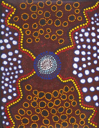
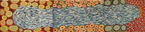
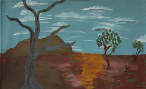
Kulyakartu

“Long time ago I been there. It is my grandmother’s, grandfather’s, father’s, [and] mother’s country, Kulyakartu.  I am painting this particular place. It keeps me connected, [gives me a] sense of belonging [to] tell my grandmother’s story through my art.  Where she was born, I’m a part of that. 

It makes me feel proud painting.  Most important is telling the story behind the painting so people can understand where I am coming from.  Kulyakartu is our ngurra (home Country, camp).  I will continue telling the story through my art.”

– Derrick Butt

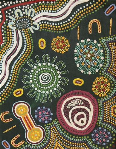
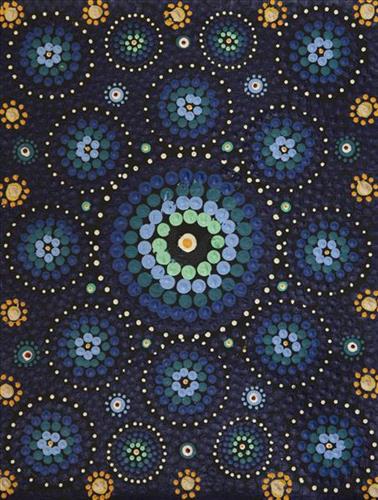
This painting depicts Kulyakartu, Derrick’s ancestral ngurra (home Country, camp). Kulyakartu is a large area in the far north of the Martu homelands, near the Percival Lakes region of Western Australia’s Great Sandy Desert. Kulyakartu is mostly flat grass Country, and is known as a good hunting area. In particular, parnajarrpa (goanna), wild cats, and lunki (witchetty grub) are found in abundance here. In the wantajarra (wet season) the dry lakes in the region fill with water.

111582378393


Untitled

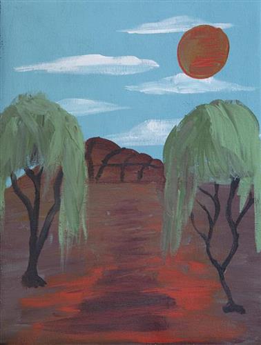
Martumili Artists work with over three hundred artists from remote Martu Aboriginal communities, including Punmu, Parnngurr, Kunawarritji, Jigalong, Irrungadji (Nullagine), and Warralong, as well as from the Parnpajinya (Newman) gallery and studio spaces. Known for their diverse, energetic, and unmediated painting styles, their works reflect the dramatic geography and scale of their homelands. Each artist, however, brings a unique approach to their craft.

Younger Martu artists often start painting alongside their parents, grandparents, and extended family, which fosters an organic learning process. This not only involves mastering painting techniques but also understanding specific locations, family histories, traditional ways of life, bush tucker, and Jukurrpa (Dreaming). Over time, with encouragement from their peers, they develop their own distinct styles and explore unique painting techniques and subject matter. In this work the artist brings a contemporary, evolving perspective to their work.

111582378842


Untitled

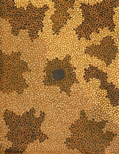
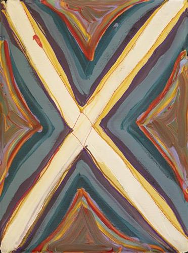
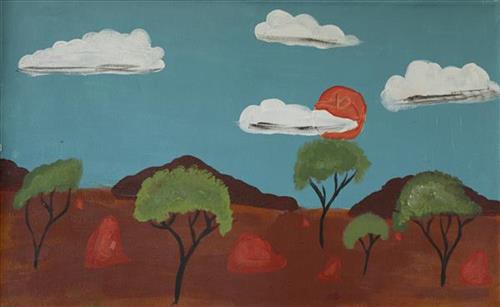
This work portrays an area known to the artist, painted here from memory. During the pujiman (traditional, desert dwelling) era one’s survival depended on their intimate knowledge of the location of resources; thus physical elements of Country, such as sources of kapi (water), tali (sandhills), and different varieties of warta (trees, vegetation) were carefully observed and remembered. Today, this relationship with Country remains equally strong, despite the movement of Martu out of the desert and into remote Aboriginal communities, towns and cities.

Also visible may be traces of life cycles based around kalyu (rain, water) and waru (fire). A thousands of year old practice, fire burning continues to be carried out as both an aid for hunting and a means of land management today. As the Martu travelled and hunted they would burn tracts of land, ensuring plant and animal biodiversity and reducing the risk of unmanageable, spontaneous bush fires. The patchwork nature of regrowth is visible in many landscape works, with each of the five distinctive phases of fire burning visually described with respect to the cycle of burning and regrowth.  

Finally, metaphysical information relating to a location may also be recorded; Jukurrpa (Dreaming) narratives chronicle the creation of physical landmarks, and can be referenced through depictions of ceremonial sites, songlines, and markers left in the land. 

111582378831


Untitled

“When Martu paint, it’s like a map. Martu draw story on the ground and on the canvas, and all the circle and line there are the hunting areas and different waters and tracks where people used to walk, and [some you] can’t cross, like boundaries. So nowadays you see a colourful painting and wonder what it is, but that’s how Martu tell story long ago. It’s not just a lovely painting, it’s a story and a songline and a history and everything that goes with it.” 

– Ngalangka Nola Taylor and Joshua Booth

This work portrays an area of Country that can be interpreted in multiple ways. Firstly, the image may be read as an aerial representation of a particular location known to the artist- either land that they or their family travelled, from the pujiman (traditional, desert dwelling) era to now. During the pujiman period, Martu would traverse very large distances annually in small family groups, moving seasonally from water source to water source, and hunting and gathering bush tucker as they went. At this time, one’s survival depended on their intimate knowledge of the location of resources; thus physical elements of Country, such as sources of kapi (water), tali (sandhills), different varieties of warta (trees, vegetation), ngarrini (camps), and jina (tracks) are typically recorded with the use of a use of a system of iconographic forms universally shared across the desert. 

An additional layer of meaning in the work relates to more intangible concepts; life cycles based around kalyu (rain, water) and waru (fire) are also often evident. A thousands of year old practice, fire burning continues to be carried out as both an aid for hunting and a means of land management today. As the Martu travelled and hunted they would burn tracts of land, ensuring plant and animal biodiversity and reducing the risk of unmanageable, spontaneous bush fires. The patchwork nature of regrowth is evident in many landscape works, with each of the five distinctive phases of fire burning visually described with respect to the cycle of burning and regrowth.  

Finally, metaphysical information relating to a location may also be recorded; Jukurrpa (Dreaming) narratives chronicle the creation of physical landmarks, and can be referenced through depictions of ceremonial sites, songlines, and markers left in the land. Very often, however, information relating to Jukurrpa is censored by omission, or alternatively painted over with dotted patterns.
111582378830


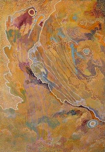
Nyurnma (Freshly Burnt Country) near Punmu (2018) – Wokka Taylor

“Nyurnma (freshly burnt Country), burnt area north from Punmu [in]sandhill Country.

One big one, no yukuri (green grass, vegetation) left. Last year [2018], no rain yet. Big area. From lighting did it, it started that waru (fire). It kept burning from the westerly wind turning it kakarra (east) [moves hands around gesturing the fire moving around]. That burning was moving around. No rocks, only tuwa (sandhills) tuwa, tuwa and waru.

I went up in the helicopter from Punmu and saw that Country. That time the waru finished. The country was clear- good for hunting, you can easily see the tracks. Plenty parnajarrpa (sand goanna) there, big one. Nyurnma only. It was a no good feeling- really big one, out of control [The fire was burning a large area of Country and became out of control].

Long time ago in pujiman (traditional, desert dwelling) times same way- big fires would start from lighting. Here is the red dirt, marked little bit like the colours left after a camp fire, but from lighting here now.”

– Wokka Taylor (dec.)

This work depicts Country around Punmu following a large and uncontrolled fire that resulted from a lightning storm in 2018. This type of fire differs to the controlled fire burning as it continues to be practiced through the Martu homelands. Over thousands of years, as Martu travelled and hunted on foot they would burn tracts of land, using waru as a means to assist with hunting, to encourage regenerative growth, and to increase biodiversity.

Targeted waru is an important tool in animal tracking. Small burns are lit to clear vegetation, expose burrows, and to allow for access to walk and track readily in exposed sands. Fires are typically burnt during cooler weather in small, controlled areas, reducing the risk of unmanageable, spontaneous bush fires like that depicted in this work. Remaining is a defined mosaic fire scar pattern in the land, across tali (sand dunes), linyji (claypans), parulyukurru (spinifex country) and pila (sandy plains).

111582378829


Desert Night Sky

“When Martu paint, it’s like a map. Martu draw story on the ground and on the canvas, and all the circle and line there are the hunting areas and different waters and tracks where people used to walk, and [some you] can’t cross, like boundaries. So nowadays you see a colourful painting and wonder what it is, but that’s how Martu tell story long ago. It’s not just a lovely painting, it’s a story and a songline and a history and everything that goes with it.” 

– Ngalangka Nola Taylor and Joshua Booth

This work portrays an area of Country that can be interpreted in multiple ways. Firstly, the image may be read as an aerial representation of a particular location known to the artist- either land that they or their family travelled, from the pujiman (traditional, desert dwelling) era to now. During the pujiman period, Martu would traverse very large distances annually in small family groups, moving seasonally from water source to water source, and hunting and gathering bush tucker as they went. At this time, one’s survival depended on their intimate knowledge of the location of resources; thus physical elements of Country, such as sources of kapi (water), tali (sandhills), different varieties of warta (trees, vegetation), ngarrini (camps), and jina (tracks) are typically recorded with the use of a use of a system of iconographic forms universally shared across the desert. 

An additional layer of meaning in the work relates to more intangible concepts; life cycles based around kalyu (rain, water) and waru (fire) are also often evident. A thousands of year old practice, fire burning continues to be carried out as both an aid for hunting and a means of land management today. As the Martu travelled and hunted they would burn tracts of land, ensuring plant and animal biodiversity and reducing the risk of unmanageable, spontaneous bush fires. The patchwork nature of regrowth is evident in many landscape works, with each of the five distinctive phases of fire burning visually described with respect to the cycle of burning and regrowth.  

Finally, metaphysical information relating to a location may also be recorded; Jukurrpa (Dreaming) narratives chronicle the creation of physical landmarks, and can be referenced through depictions of ceremonial sites, songlines, and markers left in the land. Very often, however, information relating to Jukurrpa is censored by omission, or alternatively painted over with dotted patterns.
111582378828


Kumpupirntily (Kumpupintily, Lake Disappointment)

“That’s Kumpupirntily- Lake Disappointment. The cannibals live underneath the lake there. It’s a salt lake. That’s all the ladies sitting around the lake, sitting around the claypans in the lake. That’s our Country; mine and Yunkurra’s [Billy Atkins’] Country.”

– Judith Anya Samson

Kumpupirntily lies within Anya’s ngurra (home Country, camp) through her family. This a stark, flat and unforgiving expanse of blinding salt lake is surrounded by sand hills, and located in the Little Sandy and Gibson Desert of Western Australia. Kumpupirntily translates to ‘bladder burst’; the lake was formed when the bladder of the Jila Kujarra (Two Snakes) burst here. Jila Kujarra is one of the key Jukurrpa (Dreaming) narratives for the Martu. Though the story belongs to Warnman people, it is shared across the Western Desert with several other language groups. The narrative centres on the travels of two snakes as they are pursued by the Niminjarra, spiritual ancestors of the Warnman people. 

Later in the Jukurrpa period the Ngayurnangalku (ancestral cannibal beings) made Kumpupirntily their home, where they continue to remain today. For this reason Kumpupirntily is considered one of the most sacred and dangerous sites of the Western Desert. The Ngayurnangalku are fearsome ancestral cannibal beings said to resemble people in their appearance, except for their fangs and long curved knife like fingernails they use to catch and hold their human victims. 

At Kumpupirntily, the Ngayurnangalku had a meeting to debate whether or not they would continue to live as cannibals, and eventually came to the decision to stop eating people. That night, a female baby cannibal was born. Following protocol, the baby also had to be consulted by the group. She determined that the Ngayurnangalku should continue to eat people. Her decision divided the group, and from this point the group from the east continued to live as ‘bad’ cannibals at Kumpupirntily, while the group from the west became ‘good’, thereafter consuming only animals. 

The cannibal Ngayurnangalku still live beneath the crust of Kumpupirntily lake in an underground world lit by their own sun. They surface only to feed on human flesh, coming in and out of the world we see through a small hill that acts as a gateway between worlds; Yapu Maparnpa (magical hill). Stored with the Ngayurnangalku in their underground world is an arsenal of maparnpa (holding power for sorcery) weapons, as well as deposits of pujurrpa (red ochre) that the Ngayurnangalku use to paint themselves with when they dance.

Several phenomena at Kumpupirntily act as a warning of the imminent appearance of the Ngayurnangalku; still skies, wilany (boomerang-shaped clouds), and the emergence of the parla-parla (type of lizard), smacking their mouths. The vigilance of the Martu as they travel in the Country around Kumpupirntily is so great that several other precautions are followed; fires are not lit, planes and helicopters are not flown directly over the area, and digging in the lake is strongly discouraged. All of these activities are believed to disturb the Ngayurnangalku, causing them to rise from their underground world.

111582378825


Mungili Claypan

“When I was young, [I would] walk around, play around, slide around on the mud. [At Mungili, there’s a] Big one [claypan] and little ones on the side. And the white gums, [where] we would get witchetty grubs”

– Marlene Anderson

In this work Marlene depicts a claypan located in Mungili, the small outstation community situated just off the Eagle Highway in Western Australia. Mungili lies approximately 430 kilometres northeast of Wiluna and 250 kilometres north of Warburton. Marlene grew up in Mungili, and as such it forms a significant part of her ‘ngurra’ (home Country, camp). Typically Marlene depicts this site with a central large circular form that represents the main claypan, surrounded by smaller circular forms symbolising satellite water bodies.

During the pujiman (traditional, desert dwelling) period, knowledge of water sources was critical for survival, and today Martu Country is still defined in terms of the location and type of water. Each of the hundreds of claypans, rockholes, waterholes, soaks and springs found in the Martu desert homelands is known through real life experience and the recounting of Jukurrpa (Dreaming) narratives by name, location, quality and seasonal availability. This encyclopedic knowledge extends even to the nature and movement of arterial waterways, and sustained Martu as they travelled across their Country, hunting and gathering, visiting family, and fulfilling ceremonial obligations. They would traverse very large distances annually, visiting specific areas in the dry and wet season depending on the availability of water and the corresponding cycles of plant and animal life on which hunting and gathering bush tucker was reliant.

111582378818


Untitled

This work portrays an area known to the artist, painted here from memory. During the pujiman (traditional, desert dwelling) era one’s survival depended on their intimate knowledge of the location of resources; thus physical elements of Country, such as sources of kapi (water), tali (sandhills), and different varieties of warta (trees, vegetation) were carefully observed and remembered. Today, this relationship with Country remains equally strong, despite the movement of Martu out of the desert and into remote Aboriginal communities, towns and cities.

Also visible may be traces of life cycles based around kalyu (rain, water) and waru (fire). A thousands of year old practice, fire burning continues to be carried out as both an aid for hunting and a means of land management today. As the Martu travelled and hunted they would burn tracts of land, ensuring plant and animal biodiversity and reducing the risk of unmanageable, spontaneous bush fires. The patchwork nature of regrowth is visible in many landscape works, with each of the five distinctive phases of fire burning visually described with respect to the cycle of burning and regrowth.  

Finally, metaphysical information relating to a location may also be recorded; Jukurrpa (Dreaming) narratives chronicle the creation of physical landmarks, and can be referenced through depictions of ceremonial sites, songlines, and markers left in the land. 

111582378817


Untitled

This work portrays an area known to the artist, painted here from memory. During the pujiman (traditional, desert dwelling) era one’s survival depended on their intimate knowledge of the location of resources; thus physical elements of Country, such as sources of kapi (water), tali (sandhills), and different varieties of warta (trees, vegetation) were carefully observed and remembered. Today, this relationship with Country remains equally strong, despite the movement of Martu out of the desert and into remote Aboriginal communities, towns and cities.

Also visible may be traces of life cycles based around kalyu (rain, water) and waru (fire). A thousands of year old practice, fire burning continues to be carried out as both an aid for hunting and a means of land management today. As the Martu travelled and hunted they would burn tracts of land, ensuring plant and animal biodiversity and reducing the risk of unmanageable, spontaneous bush fires. The patchwork nature of regrowth is visible in many landscape works, with each of the five distinctive phases of fire burning visually described with respect to the cycle of burning and regrowth.  

Finally, metaphysical information relating to a location may also be recorded; Jukurrpa (Dreaming) narratives chronicle the creation of physical landmarks, and can be referenced through depictions of ceremonial sites, songlines, and markers left in the land.