111582339734


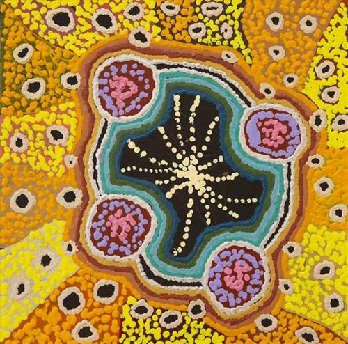
Untitled

Martumili Artists work with over three hundred artists from remote Martu Aboriginal communities, including Punmu, Parnngurr, Kunawarritji, Jigalong, Irrungadji (Nullagine), and Warralong, as well as from the Parnpajinya (Newman) gallery and studio spaces. Known for their diverse, energetic, and unmediated painting styles, their works reflect the dramatic geography and scale of their homelands. Each artist, however, brings a unique approach to their craft.

Younger Martu artists often start painting alongside their parents, grandparents, and extended family, which fosters an organic learning process. This not only involves mastering painting techniques but also understanding specific locations, family histories, traditional ways of life, bush tucker, and Jukurrpa (Dreaming). Over time, with encouragement from their peers, they develop their own distinct styles and explore unique painting techniques and subject matter. In this work the artist brings a contemporary, evolving perspective to their work.

111582339733


Untitled

“When Martu paint, it’s like a map. Martu draw story on the ground and on the canvas, and all the circle and line there are the hunting areas and different waters and tracks where people used to walk, and [some you] can’t cross, like boundaries. So nowadays you see a colourful painting and wonder what it is, but that’s how Martu tell story long ago. It’s not just a lovely painting, it’s a story and a songline and a history and everything that goes with it.” 

– Ngalangka Nola Taylor and Joshua Booth

This work portrays an area of Country that can be interpreted in multiple ways. Firstly, the image may be read as an aerial representation of a particular location known to the artist- either land that they or their family travelled, from the pujiman (traditional, desert dwelling) era to now. During the pujiman period, Martu would traverse very large distances annually in small family groups, moving seasonally from water source to water source, and hunting and gathering bush tucker as they went. At this time, one’s survival depended on their intimate knowledge of the location of resources; thus physical elements of Country, such as sources of kapi (water), tali (sandhills), different varieties of warta (trees, vegetation), ngarrini (camps), and jina (tracks) are typically recorded with the use of a use of a system of iconographic forms universally shared across the desert. 

An additional layer of meaning in the work relates to more intangible concepts; life cycles based around kalyu (rain, water) and waru (fire) are also often evident. A thousands of year old practice, fire burning continues to be carried out as both an aid for hunting and a means of land management today. As the Martu travelled and hunted they would burn tracts of land, ensuring plant and animal biodiversity and reducing the risk of unmanageable, spontaneous bush fires. The patchwork nature of regrowth is evident in many landscape works, with each of the five distinctive phases of fire burning visually described with respect to the cycle of burning and regrowth.  

Finally, metaphysical information relating to a location may also be recorded; Jukurrpa (Dreaming) narratives chronicle the creation of physical landmarks, and can be referenced through depictions of ceremonial sites, songlines, and markers left in the land. Very often, however, information relating to Jukurrpa is censored by omission, or alternatively painted over with dotted patterns.

111582339732


Untitled

This is Mayiwalku’s Country- her ‘ngurra’ (home Country, camp). People identify with their ngurra in terms of specific rights and responsibilities, and the possession of intimate knowledge of the physical and cultural properties of one’s Country. Painting ngurra, and in so doing sharing the Jukurrpa (Dreaming) stories and physical characteristics of that place, has today become an important means of cultural maintenance. 

Mayiwalku’s ngurra encompasses the Country that she and her family walked in the pujiman (traditional, desert-dwelling) era. Mayiwalku was born at Yirnangarri. She grew up, walked and hunted primarily around the Country extending across the Punmu, Kunawarritji (Canning Stock Route Well 33) and Karlamilyi (Rudall River) regions. Following the death of both their parents, Mayiwalku and her sisters travelled alone between Punmu and Kunawarritji, occasionally meeting with other family groups. They continued to live nomadically before eventually deciding to move to Jigalong Mission along with many other relatives following an extreme and prolonged drought in the 1960s. 

Portrayed in this work are features of Mayiwalku’s ngurra, such as the dominant permanent red tali (sandhills), warta (trees, vegetation), and the individually named water sources she and her family camped at. These include Januwa, Jilankujarra, Karlajarntu, Kartungu, Kularti, Kumpupajanu, Kunalimpi, Kunarra, Marnakarti, Pangkapirni, Wilunganinya, Wurur-wururna, Yilyara, and Yirrajarra Rock holes, waterholes, soaks and springs were all extremely important sites for Martu people during the pujiman period, and are generally depicted with circular forms. 

The encyclopaedic knowledge of the location, quality and seasonal availability of the hundreds of water bodies found in one’s Country sustained Martu as they travelled across their Country, hunting and gathering, visiting family, and fulfilling ceremonial obligations. They would traverse very large distances annually, visiting specific areas in the dry and wet season depending on the availability of water and the corresponding cycles of plant and animal life on which hunting and gathering bush tucker was reliant. As they travelled and hunted they would also burn areas of Country, generating a greater diversity of plant and animal life.

111582339731


Untitled

This is Mayiwalku’s Country- her ‘ngurra’ (home Country, camp). People identify with their ngurra in terms of specific rights and responsibilities, and the possession of intimate knowledge of the physical and cultural properties of one’s Country. Painting ngurra, and in so doing sharing the Jukurrpa (Dreaming) stories and physical characteristics of that place, has today become an important means of cultural maintenance. 

Mayiwalku’s ngurra encompasses the Country that she and her family walked in the pujiman (traditional, desert-dwelling) era. Mayiwalku was born at Yirnangarri. She grew up, walked and hunted primarily around the Country extending across the Punmu, Kunawarritji (Canning Stock Route Well 33) and Karlamilyi (Rudall River) regions. Following the death of both their parents, Mayiwalku and her sisters travelled alone between Punmu and Kunawarritji, occasionally meeting with other family groups. They continued to live nomadically before eventually deciding to move to Jigalong Mission along with many other relatives following an extreme and prolonged drought in the 1960s. 

Portrayed in this work are features of Mayiwalku’s ngurra, such as the dominant permanent red tali (sandhills), warta (trees, vegetation), and the individually named water sources she and her family camped at. These include Januwa, Jilankujarra, Karlajarntu, Kartungu, Kularti, Kumpupajanu, Kunalimpi, Kunarra, Marnakarti, Pangkapirni, Wilunganinya, Wurur-wururna, Yilyara, and Yirrajarra Rock holes, waterholes, soaks and springs were all extremely important sites for Martu people during the pujiman period, and are generally depicted with circular forms. 

The encyclopaedic knowledge of the location, quality and seasonal availability of the hundreds of water bodies found in one’s Country sustained Martu as they travelled across their Country, hunting and gathering, visiting family, and fulfilling ceremonial obligations. They would traverse very large distances annually, visiting specific areas in the dry and wet season depending on the availability of water and the corresponding cycles of plant and animal life on which hunting and gathering bush tucker was reliant. As they travelled and hunted they would also burn areas of Country, generating a greater diversity of plant and animal life.

111582339292


Nganjirr

“Grandfather’s Country, not far from Well 33, called Nganjirr. Not far, [you] can go up by car. Go camping there. When it rains, fills up, then is dry.

Two Countries – Nganjirr and Kun Kun (Kuny-Kuny), Marlene’s Country. [You] can just go out for the day- lovely and quiet. Go hunting and get some jinyjwirrily (wild gooseberry, or desert raisins)”

– Kara Patch

Nganjirr and Kun Kun are both significant parts of Kara’s ‘ngurra’ (home Country, camp). Nganjirr, a grouping of three rockholes just south of Kil-kil (Canning Stock Route Well 36), is an importaint place for the Patch family through two brothers, Nganjirrmarta and Wirrulypa. A large marntila/tarntulu (Acacia pruinocarpa) sitting on rocky outcrop close to Nganjirr is used to locate the rockholes.

Kun Kun (Kuny-kuny) is a soak accessing a large body of underground water, located southeast of Kunawarritji (Canning Stock Route Well 33). The site is sacred for its association with the marlu (kangaroo) Jukurrpa (Dreaming), and was an important ceremonial site during the pujiman (traditional, desert dwelling) period. Soaks, or soakwaters, derive their name from the manner in which their waters generally seep into the sand from below stores, sometimes as part of an ephemeral river or creek. Soaks were an especially important source of water during the pujiman era, being the most dependable water source in times of drought. Water was obtained from soaks by scooping away the sand with a piti (timber bowls used for carrying food and water) until clear water gathered at the base of the hole, sometimes at a depth of several metres.

In the Pujiman time, Martu would traverse very large distances annually in small family groups, moving seasonally from water source to water source, and hunting and gathering bush tucker as they went. Knowledge of water sources was critical for survival, and today Martu Country is still defined in terms of the location and type of water. Each of the hundreds of claypans, rockholes, waterholes, soaks and springs found in the Martu desert homelands is known by name, location, quality and seasonal availability through real life experience and the recounting of Jukurrpa narratives.

111582339290


Rabbit Proof Fence

“When I was a little girl, my sister and I would visit our nanna [Molly Craig]. We really looked after her and checked if she had any food and sometimes she would say ” I’m hungry one.” We would race home to make damper and cook some meat and take it back to her before it got dark. She was a caring and beautiful lady but she never told her story about what happened when she was young because my sister and I were part of welfare. That’s why my sister and I had a great connection with our nanna, an unspoken connection.”

– Kathleen Sorenson

In 1931 sisters Molly Craig, Daisy Kadibil and Gracie Fields were taken from their families, like many other Aboriginal children at that time, and transported to Moore River Native Settlement, north of Perth. They were taken away in the belief that part-Aboriginal children should be trained as domestic servants. 

The three girls escaped the next day and, incredibly, walked 1600 kilometres home to Jigalong using the Rabbit-Proof Fence to navigate. The Rabbit Proof Fence remains the world’s longest fence, and was built in the early 1900s to separate rabbits from pasture. For nine weeks, the girls followed its length in order to be reunited with their family. They crossed a flooded river, sand dunes, heathlands, wheatbelts and plains, claypans and salt lakes. They slept in dug-out rabbit burrows, and caught and cooked rabbits, along with other plant based bush tucker. For the duration of their journey they were pursued by policeman and an Aboriginal police tracker.

The girls’ story has been immortalised in the novel “Follow the Rabbit-Proof Fence” by Doris Pilkington (Nugi Garimara, 1996), and was adapted into the film “Rabbit Proof Fence” (2002). This story retains special significance for the Martu, and in particular those inhabitants of Jigalong Aboriginal community. The three girls were Martu, and their children and grandchildren continue to live in the Martu homelands today.

111582339289


Mungili Claypan

“When I was young, [I would] walk around, play around, slide around on the mud. [At Mungili, there’s a] Big one [claypan] and little ones on the side. And the white gums, [where] we would get witchetty grubs”

– Marlene Anderson

In this work Marlene depicts a claypan located in Mungili, the small outstation community situated just off the Eagle Highway in Western Australia. Mungili lies approximately 430 kilometres northeast of Wiluna and 250 kilometres north of Warburton. Marlene grew up in Mungili, and as such it forms a significant part of her ‘ngurra’ (home Country, camp). Typically Marlene depicts this site with a central large circular form that represents the main claypan, surrounded by smaller circular forms symbolising satellite water bodies.

During the pujiman (traditional, desert dwelling) period, knowledge of water sources was critical for survival, and today Martu Country is still defined in terms of the location and type of water. Each of the hundreds of claypans, rockholes, waterholes, soaks and springs found in the Martu desert homelands is known through real life experience and the recounting of Jukurrpa (Dreaming) narratives by name, location, quality and seasonal availability. This encyclopedic knowledge extends even to the nature and movement of arterial waterways, and sustained Martu as they travelled across their Country, hunting and gathering, visiting family, and fulfilling ceremonial obligations. They would traverse very large distances annually, visiting specific areas in the dry and wet season depending on the availability of water and the corresponding cycles of plant and animal life on which hunting and gathering bush tucker was reliant.

111582339280


Wantili (Warntili, Canning Stock Route Well 25) – Ngamaru Bidu

“Wantili (Warntili, Canning Stock Route Well 25) area, close to Parnngurr. My ngurra (home Country, camp), my jamu’s (grandfather’s) Country, my father’s daddy, Jakayu [Biljabu’s] daddy and my daddy’s Country. Jakayu been bury her father there. In pujiman (traditional, desert dwelling) days, my family and Jakayu’s family been walking round there together. Big sandhills here. Sandhill, sandhill, sandhill everywhere. Claypan there, in the middle. Good place for swimming and drinking, for hunting little kangaroo. When no water [we would] go to [the adjacent Canning Stock Route] well. When there [was] rain we stay there at Wantili. Everywhere, we been walking everywhere.       

Near to Wantili, road [Canning Stock Route] going kayili (north). Long time [ago] only horses and cattle [travelled along that road], going Meekatharra and back in the cold time, gone right up to GJ (Georgia) Bore. Half way, when he see water at Wantili, that mob would camp one night, bullock eating all the grass and men’s drinking water. One Martu been working with that mob, droving bullock. Every time he been give us meat, all the pujimanpa (desert dwellers).”

– Ngamaru Bidu


Wantili is a large round jurnu (soak) and linyji (claypan) near Well 25 on the Canning Stock Route. The Wantili region is dominated by claypans surrounded by tuwa (sandhills), and Nyilangkurr, a prominent yapu (hill) is located close to the eastern edge of the claypan. Following rain the typically dry claypans are filled with water, with the overflow from nearby waterholes flowing to Wantili. At that time, Wantili becomes an important place for obtaining fresh water for drinking and bathing. Wantili is significant for the fact that at this site Kartujarra, Manyjilyjarra, Putijarra and Warnman people would all come together for ceremonies during the pujiman era. Many jiwa (stones used by women for grinding seeds) from these times, including those used by Ngamaru’s family, can still be found there today.

Wantili lies within Ngamaru’s ngurra (home Country, camp) through her grandfather and father. As described in her account, Wantili was one of the sites Ngamaru knew intimately and travelled extensively with her family and other family groups, such as the Biljabu family. During the pujiman period Martu would traverse very large distances annually, moving seasonally from water source to water source, and hunting and gathering bush tucker as they went. Knowledge of water sources was critical for survival, and today Martu Country is still defined in terms of the location and type of water. 

As Ngamaru recounts, Wantili also held significance for her as a site of contact between her family and kartiya (white people); drovers with their cattle travelling along the Canning Stock Route. The establishment of the route by Alfred Canning and his team in 1910 resulted in first contact with Europeans for many Martu, including Ngamaru and her family. Increasingly, Martu followed the route to newly established ration depots, mission and pastoral stations. They were drawn to the route in search of food, by a sense of curiosity, or by loneliness. By the late 1950s and early 1960s, most of the desert family groups had left the desert. Eventually, these factors combined with an extreme and prolonged drought in the 1960s to prompt the few remaining pujimanpa to move in from the desert. 

Culturally, Wantili is an incredibly important site in two central Jukurrpa (Dreaming) stories. The first relates to the world’s creation. In this narrative, the world was initially dark, and people were like rocks, with no arms or legs. Following the sun’s first rising, life-forms become increasingly complex while particular features in the land are created. Beyond these details much of the narrative is ngurlu (sacred, taboo), and only for Martu, but the site is open, and anyone can go there. 

Wantili is also one of the many sites featured in the epic Minyipuru (Jakulyukulyu, Seven Sisters) Jukurrpa story. Minyipuru is a central Jukurrpa narrative for Martu, Ngaanyatjarra, Pitjantjatjara and Yankunytjatjara people that is associated with the seasonal Pleiades star constellation. Relayed in song, dance, stories and paintings, Minyipuru serves as a creation narrative, a source of information relating to the physical properties of the land, and an embodiment of Aboriginal cultural laws. The story follows the movement of a group of women travelling all the way across the desert, beginning at Roebourne on the coast of Western Australia, as they are pursued by Yurla, a lustful old man. As the women travelled, they stopped to rest at many sites to eat, dance, rest and sing, on the way leaving behind an assortment of articles that became formations in the land, such as groupings of rocks and trees, grinding stones and seeds. The sisters rested at Wantili before throwing seeds, then continued their journey far to the east and beyond Martu Country, stopping at various sites through central and South Australia.

111582339274


Wantili (Warntili, Canning Stock Route Well 25)

“Bugai always tells about Wantili (Warntili, Canning Stock Route Well 25) because she grew up around Wantili. Her family would travel between Wantili, Kaalpa, Juntu-juntu, Raarki, and Wuranu Wells along the Canning Stock Route. She paints around Wantili. She saw whitefellas there for the first time, Canning mob when they were travelling up and down the stock route with the bullock. She was a young girl walking around at Wantili. Big mob of people they been walking around there. Canning and his drovers were travelling, making the road. They were running away from those whitefellas, watching them from a long distance. She was a teenager when she was travelling around there with her four mothers and one daddy. They used to travel around in family groups, Bugai and Jakayu [Biljabu], and Jakayu’s nyupa (partner) Phillip Biljabu.” 

– Bugai Whyoulter, as translated by her grandson, Cyril Whyoulter


“I was just becoming a teenager, still travelling around with my mother and father. We were at Juntu-juntu, Wuranu, Raarki, Tiwa and Wantili. At Wantili we killed a cow, they were bringing cattle through from Kunawarritji … Wantili was a good place to make yakapiri (woven bark sandals).”

– Bugai Whyoulter as translated by Ngalangka Nola Taylor


Wantili, which forms the focus of much of Bugai’s work, is a large round jurnu (soak) and linyji (claypan) near Well 25 on the Canning Stock Route. The Wantili region is dominated by claypans surrounded by tuwa (sandhills), and Nyilangkurr, a prominent yapu (hill) is located close to the eastern edge of the claypan. Following rain the typically dry claypans are filled with water, with the overflow from nearby waterholes flowing to Wantili. At that time, Wantili becomes an important place for obtaining fresh water for drinking and bathing. Wantili is significant for the fact that at this site Kartujarra, Manyjilyjarra, Putijarra and Warnman people would all come together for ceremonies during the pujiman (traditional, desert dwelling) era. Many jiwa (stones used by women for grinding seeds) from these times can still be found there today.

Wantili lies within Bugai’s ngurra (home Country, camp). As described in her account, Wantili was one of the sites she knew intimately and travelled extensively with her family and other family groups during the pujiman period. At this time, Martu would traverse very large distances annually, moving seasonally from water source to water source, and hunting and gathering bush tucker as they went. Knowledge of water sources was critical for survival, and today Martu Country is still defined in terms of the location and type of water. Each of the hundreds of claypans, rockholes, waterholes, soaks and springs found in the Martu desert homelands is known by name, location, quality and seasonal availability through real life experience and the recounting of Jukurrpa (Dreaming) narratives. 

Wantili is also especially significant to Bugai as it was here that she saw whitefellas for the first time; drovers with their cattle travelling along the Canning Stock Route. The establishment of the route by Alfred Canning and his team in 1910 resulted in first contact with Europeans for many Martu, including Bugai and her family, then living a pujiman life in the desert. Encounters occurred between Martu, Europeans, and other Martu working as cattle drovers as they travelled and down the Stock Route from water source to water source. Increasingly, Martu followed the route to newly established ration depots, mission and pastoral stations. They were drawn to the route in search of food, by a sense of curiosity, or by loneliness. By the late 1950s and early 1960s, most of the desert family groups had left the desert. Eventually, these factors combined with an extreme and prolonged drought in the 1960s to prompt the few remaining pujiman to move in from the desert. Bugai returned to the Wantili area as a young woman, when she herself drove cattle along the Stock Route.

Culturally, Wantili is an incredibly important site, ‘where the creation started.’ (Cyril Whyoulter). In this creation story, the world was initially dark, and people were like rocks, with no arms or legs. Following the sun’s first rising, life-forms become increasingly complex while particular features in the land are created. Beyond these details much of the Jukurrpa narrative relating to Wantili is ngurlu (sacred, taboo), and only for Martu, but the site is open, and anyone can go there. 

Wantili is also one of the many sites featured in the epic Minyipuru (Jakulyukulyu, Seven Sisters) Jukurrpa story. Minyipuru is a central Jukurrpa narrative for Martu, Ngaanyatjarra, Pitjantjatjara and Yankunytjatjara people that is associated with the seasonal Pleiades star constellation. Relayed in song, dance, stories and paintings, Minyipuru serves as a creation narrative, a source of information relating to the physical properties of the land, and an embodiment of Aboriginal cultural laws. The story follows the movement of a group of women travelling all the way across the desert, beginning at Roebourne on the coast of Western Australia, as they are pursued by Yurla, a lustful old man. As the women travelled, they stopped to rest at many sites to eat, dance, rest and sing, on the way leaving behind an assortment of articles that became formations in the land, such as groupings of rocks and trees, grinding stones and seeds. The sisters rested at Wantili before throwing seeds, then continued their journey far to the east and beyond Martu Country, stopping at various sites through central and South Australia.

111582339273


Wantili (Warntili, Canning Stock Route Well 25)

“Bugai always tells about Wantili (Warntili, Canning Stock Route Well 25) because she grew up around Wantili. Her family would travel between Wantili, Kaalpa, Juntu-juntu, Raarki, and Wuranu Wells along the Canning Stock Route. She paints around Wantili. She saw whitefellas there for the first time, Canning mob when they were travelling up and down the stock route with the bullock. She was a young girl walking around at Wantili. Big mob of people they been walking around there. Canning and his drovers were travelling, making the road. They were running away from those whitefellas, watching them from a long distance. She was a teenager when she was travelling around there with her four mothers and one daddy. They used to travel around in family groups, Bugai and Jakayu [Biljabu], and Jakayu’s nyupa (partner) Phillip Biljabu.” 

– Bugai Whyoulter, as translated by her grandson, Cyril Whyoulter


“I was just becoming a teenager, still travelling around with my mother and father. We were at Juntu-juntu, Wuranu, Raarki, Tiwa and Wantili. At Wantili we killed a cow, they were bringing cattle through from Kunawarritji … Wantili was a good place to make yakapiri (woven bark sandals).”

– Bugai Whyoulter as translated by Ngalangka Nola Taylor


Wantili, which forms the focus of much of Bugai’s work, is a large round jurnu (soak) and linyji (claypan) near Well 25 on the Canning Stock Route. The Wantili region is dominated by claypans surrounded by tuwa (sandhills), and Nyilangkurr, a prominent yapu (hill) is located close to the eastern edge of the claypan. Following rain the typically dry claypans are filled with water, with the overflow from nearby waterholes flowing to Wantili. At that time, Wantili becomes an important place for obtaining fresh water for drinking and bathing. Wantili is significant for the fact that at this site Kartujarra, Manyjilyjarra, Putijarra and Warnman people would all come together for ceremonies during the pujiman (traditional, desert dwelling) era. Many jiwa (stones used by women for grinding seeds) from these times can still be found there today.

Wantili lies within Bugai’s ngurra (home Country, camp). As described in her account, Wantili was one of the sites she knew intimately and travelled extensively with her family and other family groups during the pujiman period. At this time, Martu would traverse very large distances annually, moving seasonally from water source to water source, and hunting and gathering bush tucker as they went. Knowledge of water sources was critical for survival, and today Martu Country is still defined in terms of the location and type of water. Each of the hundreds of claypans, rockholes, waterholes, soaks and springs found in the Martu desert homelands is known by name, location, quality and seasonal availability through real life experience and the recounting of Jukurrpa (Dreaming) narratives. 

Wantili is also especially significant to Bugai as it was here that she saw whitefellas for the first time; drovers with their cattle travelling along the Canning Stock Route. The establishment of the route by Alfred Canning and his team in 1910 resulted in first contact with Europeans for many Martu, including Bugai and her family, then living a pujiman life in the desert. Encounters occurred between Martu, Europeans, and other Martu working as cattle drovers as they travelled and down the Stock Route from water source to water source. Increasingly, Martu followed the route to newly established ration depots, mission and pastoral stations. They were drawn to the route in search of food, by a sense of curiosity, or by loneliness. By the late 1950s and early 1960s, most of the desert family groups had left the desert. Eventually, these factors combined with an extreme and prolonged drought in the 1960s to prompt the few remaining pujiman to move in from the desert. Bugai returned to the Wantili area as a young woman, when she herself drove cattle along the Stock Route.

Culturally, Wantili is an incredibly important site, ‘where the creation started.’ (Cyril Whyoulter). In this creation story, the world was initially dark, and people were like rocks, with no arms or legs. Following the sun’s first rising, life-forms become increasingly complex while particular features in the land are created. Beyond these details much of the Jukurrpa narrative relating to Wantili is ngurlu (sacred, taboo), and only for Martu, but the site is open, and anyone can go there. 

Wantili is also one of the many sites featured in the epic Minyipuru (Jakulyukulyu, Seven Sisters) Jukurrpa story. Minyipuru is a central Jukurrpa narrative for Martu, Ngaanyatjarra, Pitjantjatjara and Yankunytjatjara people that is associated with the seasonal Pleiades star constellation. Relayed in song, dance, stories and paintings, Minyipuru serves as a creation narrative, a source of information relating to the physical properties of the land, and an embodiment of Aboriginal cultural laws. The story follows the movement of a group of women travelling all the way across the desert, beginning at Roebourne on the coast of Western Australia, as they are pursued by Yurla, a lustful old man. As the women travelled, they stopped to rest at many sites to eat, dance, rest and sing, on the way leaving behind an assortment of articles that became formations in the land, such as groupings of rocks and trees, grinding stones and seeds. The sisters rested at Wantili before throwing seeds, then continued their journey far to the east and beyond Martu Country, stopping at various sites through central and South Australia.