11152117892


Puntawarri

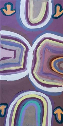
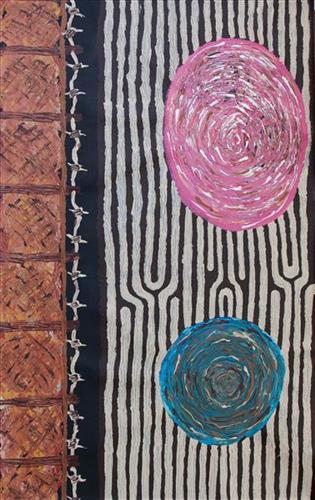
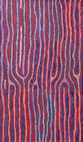
This painting depicts Puntawarri, in the artists’ family’s country. Puntawarri is on the middle stretches of the Canning Stock Route, near Well 17 also known as Durba Springs. Puntawarri is an important cultural area, east of the Jigalong Aboriginal Community, where the artist now lives with his family. The artist frequently travelled and hunted with his family in this area during pujiman (bush) days.

111582299125


Rabbit Proof Fence, Creek line to Lake Disappointment and Jilukurru.

“When I went back to my County, I thought how beautiful the spinifex was. How the sun glazed against the spinifex. The county that I speak of is Jilukurru, my grandfather’s Country.”

“My Nanna, Molly Kelly, walked the Rabbit Proof Fence. My ancestors are from Lake Disappointment and my Grandfather’s country is Jilukurru. Jilukurru is also known as Killagurra Springs and is on the Canning Stock Route, Well 17. The creek line to Lake Disappointment is called Savory creek.”


– Kathleen Maree Sorenson

Jilukurru (Killagurra Springs, Canning Stock Route Well 17) is a yinta (permanent spring) located in the hills and gorges yapurra (west) of Kumpupirntily (Kumpupintily, Lake Disappointment). This spring was an important site for meetings during the pujiman (traditional, desert dwelling) era.

Jilukurru is also sacred for its relation to the Jukurrpa (Dreaming) narrative of the Wati Kujarra (Two Goanna Men), one of the key foundational myths for Western Desert people, and for this reason access to the site is respectfully restricted. The Wati Kujarra existed as half men, half goanna. They were responsible for the creation of many land features in Martu Country and beyond as they travelled, hunted and burned Country together. Wati Kujarra is a ngurlu (sacred, taboo) men’s story, and much of the content is only shared with initiated men.

At Jilukurru, the Wati Kujarra lived for a time. Here they also trimmed their ngarnkurrpa (beards). On one of the rocky headlands of the range system, the form of the two men can be seen, with their long beards rolling down the escarpment. After the Wati Kujarra left Jilukurru the site became home to an ancestral rainmaking jila (snake).

111582299123


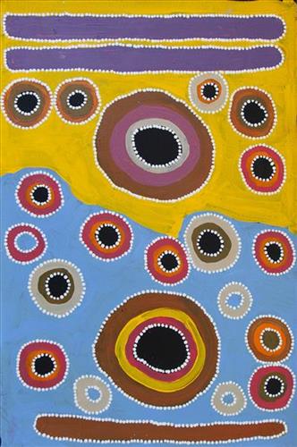
Mungili Rock Holes

“Mungili rock hole. Big rock hole, big Country. I never see that place. My mother born [there], her and her grandmother walk through there, they tell me story [for that place]. Mother born there in the Country Mungili, walking through the bush. There is a camping spot, camping in bush – bush, bush, bush. [Points at painting] This is the lake Country and goes through there.”

– Matthew Mintern Smith

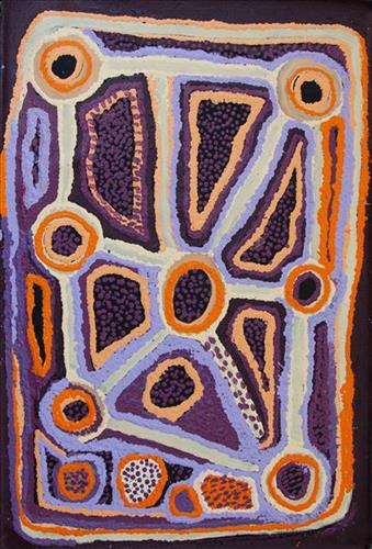
In this work Matthew depicts a claypan located in Mungili, the small outstation community situated just off the Eagle Highway in Western Australia. Mungili lies approximately 430 kilometres northeast of Wiluna and 250 kilometres north of Warburton. Mungili is ngurra (home (home Country, camp) for Matthew through his mother and grandmother. He typically depicts the site with a central large circular form that represents the main claypan, surrounded by smaller circular forms symbolising satellite water bodies.

The Western Desert term ‘ngurra’ is hugely versatile in application. Broadly denoting birthplace and belonging, ngurra can refer to a body of water, a camp site, a large area of Country, or even a modern house. People identify with their ngurra in terms of specific rights and responsibilities, and the possession of intimate knowledge of the physical and cultural properties of one’s Country. This knowledge is traditionally passed intergenerationally through family connections. Country for Martu is full of memory; not just the memory of their own movement through it, but also of their family. As summarised by Ngalangka Nola Taylor, “painting the ngurra, they do it to remember their connections.” 

Painting ngurra, and in so doing sharing the Jukurrpa (Dreaming) stories and physical characteristics of that place, has today become an important means of cultural maintenance. Physical maintenance of one’s ngurra, like cultural maintenance, ensures a site’s wellbeing, and is a responsibility of the people belonging to that area.  

111582299122


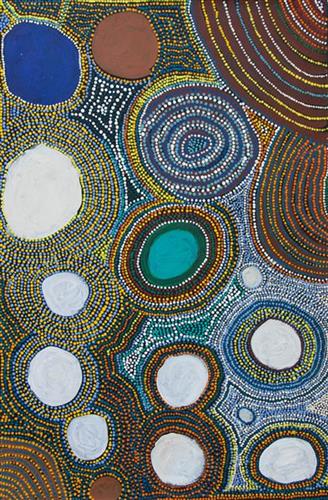
Partjantja

“Katjarra’s  [Katjarra Butler] ngurra (home Country, camp). Birthplace. [It is] sandhill country. Rockhole, little bit of rocks. And in the sandhill, there is a jurnu (soakwater). They take that water, come out [of the soakwater]. Partjanta the name of that jurnu. Main one. She [Katjarra Butler] been go jina [foot, walking]. Early days. Walking [to] Kintore, Papunya.”

“I’m painting my grandmother’s country, her way. Katjarra style.”

-Sharon Porter

This site forms part of Sharon’s ngurra (home Country, camp) through her grandmother, Katjarra Butler. Located east of Kiwirrkurra and on Pintupi country.

The Western Desert term ‘ngurra’ is hugely versatile in application. Broadly denoting birthplace and belonging, ngurra can refer to a body of water, a camp site, a large area of Country, or even a modern house. People identify with their ngurra in terms of specific rights and responsibilities, and the possession of intimate knowledge of the physical and cultural properties of one’s Country. This knowledge is traditionally passed intergenerationally through family connections. Country for Martu is full of memory; not just the memory of their own movement through it, but also of their family. As summarised by Ngalangka Nola Taylor, “painting the ngurra, they do it to remember their connections.”

Painting ngurra, and in so doing sharing the Jukurrpa (Dreaming) stories and physical characteristics of that place, has today become an important means of cultural maintenance. Physical maintenance of one’s ngurra, like cultural maintenance, ensures a site’s wellbeing, and is a responsibility of the people belonging to that area. 

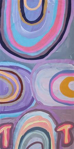
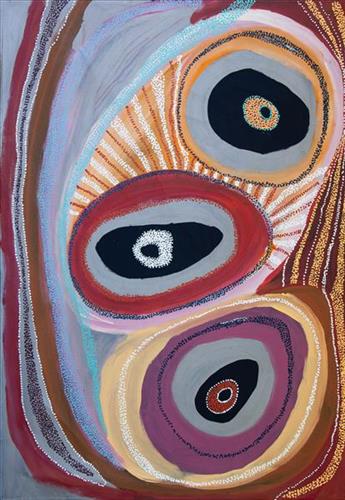
This work depicts a yinta (permanent spring) within the artists’ ngurra (home Country, camp), typically depicted with circular forms. Yinta provided a reliable source of water and were traditionally used as camping sites throughout the year.

During the pujiman (traditional, desert dwelling) period, knowledge of water sources was critical for survival, and today Martu Country is still defined in terms of the location and type of water. Each of the hundreds of claypans, rockholes, waterholes, soaks and springs found in the Martu desert homelands is known through real life experience and the recounting of Jukurrpa (Dreaming) narratives by name, location, quality and seasonal availability. This encyclopedic knowledge extends even to the nature and movement of arterial waterways, and sustained Martu as they travelled across their Country, hunting and gathering, visiting family, and fulfilling ceremonial obligations. They would traverse very large distances annually, visiting specific areas in the dry and wet season depending on the availability of water and the corresponding cycles of plant and animal life on which hunting and gathering bush tucker was reliant.

111582299120


Emu Tracks to Puntawarri

“Emu go to the springs to have a drink of water and then move on to the next one.”

– Judith Anya Samson

Puntawarri is an important cultural area, as well as the site of a now abandoned community, a waterhole, creek and lake. Puntawarri is located on the middle stretches of the Canning Stock Route and east of the Jigalong Aboriginal Community, where Judith grew up with her grandmother and senior Martumili Artist Dadda Samson (dec.). Anya continues to live between Jigalong and Newman today.

Puntawarri lies within Judith’s ngurra (home Country, camp) through her mother’s family, and as a young girl she frequently travelled and hunted with her family in this area, learning the stories for this Country. Depicted in this work are the tracks of a group of emus on their way to Puntawarri waterhole, searching for kapi (water). 

Karlaya (emu) were traditionally hunted during the pujiman (traditional, desert dwelling) era, and they continue to be a favoured bush tucker for Martu today. During the pujiman period, Martu would traverse very large distances annually in small family groups, moving seasonally from water source to water source, and hunting and gathering bush tucker as they went. Jina (tracks, footprints) are used by Martu people when tracking bush tucker. In the absence of an actual animal sighting, tracks act as an identifier that an animal was present, which can then be followed to the animal’s present location. Besides providing information on location, Martu are able to interpret from tracks the passage of time since the tracks were imprinted, as well as the corresponding animal species and its size.

The softer and more extensive the ground surface, the easier it is to locate and follow tracks, thus certain conditions are favoured for tracking. Tuulparra (spring) and yalijarra (hot time) are preferred over wantajarra (winter), when south easterly tradewinds blow strongly to obscure tracks. Tracks and burrows are also more readily visible in early growth lands, such as nyurnma (freshly burnt Country) and waru-waru (growth of new shoots and young plants). For this reason, fire burning is an important tool in animal tracking. Small burns are lit to clear vegetation, expose burrows, and to allow for access to walk and track readily in exposed sands, while simultaneously providing diverse regenerating habitats.

111582299119


Emu Tracks to Puntawarri

“Emu go to the springs to have a drink of water and then move on to the next one.”

– Judith Anya Samson

Puntawarri is an important cultural area, as well as the site of a now abandoned community, a waterhole, creek and lake. Puntawarri is located on the middle stretches of the Canning Stock Route and east of the Jigalong Aboriginal Community, where Judith grew up with her grandmother and senior Martumili Artist Dadda Samson (dec.). Anya continues to live between Jigalong and Newman today.

Puntawarri lies within Judith’s ngurra (home Country, camp) through her mother’s family, and as a young girl she frequently travelled and hunted with her family in this area, learning the stories for this Country. Depicted in this work are the tracks of a group of emus on their way to Puntawarri waterhole, searching for kapi (water). 

Karlaya (emu) were traditionally hunted during the pujiman (traditional, desert dwelling) era, and they continue to be a favoured bush tucker for Martu today. During the pujiman period, Martu would traverse very large distances annually in small family groups, moving seasonally from water source to water source, and hunting and gathering bush tucker as they went. Jina (tracks, footprints) are used by Martu people when tracking bush tucker. In the absence of an actual animal sighting, tracks act as an identifier that an animal was present, which can then be followed to the animal’s present location. Besides providing information on location, Martu are able to interpret from tracks the passage of time since the tracks were imprinted, as well as the corresponding animal species and its size.

The softer and more extensive the ground surface, the easier it is to locate and follow tracks, thus certain conditions are favoured for tracking. Tuulparra (spring) and yalijarra (hot time) are preferred over wantajarra (winter), when south easterly tradewinds blow strongly to obscure tracks. Tracks and burrows are also more readily visible in early growth lands, such as nyurnma (freshly burnt Country) and waru-waru (growth of new shoots and young plants). For this reason, fire burning is an important tool in animal tracking. Small burns are lit to clear vegetation, expose burrows, and to allow for access to walk and track readily in exposed sands, while simultaneously providing diverse regenerating habitats.

111582299118


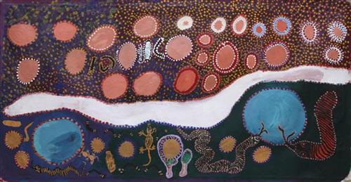
Rabbit Proof Fence, Creek line to Lake Disappointment and Jilukurru.

“When I went back to my County, I thought how beautiful the spinifex was. How the sun glazed against the spinifex. The county that I speak of is Jilukurru, my grandfather’s Country.”

“My Nanna, Molly Kelly, walked the rabbit proof fence. My ancestors are from Lake Disappointment and my Grandfather’s country is Jilukurru. Jilukurru is also known as Killagurra Springs and is on the Canning Stock Route, Well 17. The creek line to Lake Disappointment is called Savory creek.”

– Kathleen Maree Sorenson

Jilukurru (Killagurra Springs, Canning Stock Route Well 17) is a yinta (permanent spring) located in the hills and gorges yapurra (west) of Kumpupirntily (Kumpupintily, Lake Disappointment). This spring was an important site for meetings during the pujiman (traditional, desert dwelling) era.

Jilukurru is also sacred for its relation to the Jukurrpa (Dreaming) narrative of the Wati Kujarra (Two Goanna Men), one of the key foundational myths for Western Desert people, and for this reason access to the site is respectfully restricted. The Wati Kujarra existed as half men, half goanna. They were responsible for the creation of many land features in Martu Country and beyond as they travelled, hunted and burned Country together. Wati Kujarra is a ngurlu (sacred, taboo) men’s story, and much of the content is only shared with initiated men.

At Jilukurru, the Wati Kujarra lived for a time. Here they also trimmed their ngarnkurrpa (beards). On one of the rocky headlands of the range system, the form of the two men can be seen, with their long beards rolling down the escarpment. After the Wati Kujarra left Jilukurru the site became home to an ancestral rainmaking jila (snake).

111582299117


Kaalpa (Kalypa, Canning Stock Route Well 23

“Kaalpa (Kalypa, Canning Stock Route Well 23) is my grandfather’s Country. There’s a waterhole there, Kaalpa waterhole. It’s my two pops’ Country. They been walking around, hunting around Kaalpa. You can see a yapu (rock), warla (lake), claypans, karru (creek) and tuwa (sandhills) there. It’s on the [Canning] Stock Route, it’s Well 23.  

In pujiman (traditional, desert dwelling) days, pujimanpa (desert born people) walking around all this Country. My pops told me about that place, a big flat area, parlkarra (flat country) good for hunting parnajarrpa (goanna), lunki (witchetty grub), lungkurta (blue tongue lizard), wamurla (bush tomato), jinyjiwirrilyi (wild gooseberry). Kaalpa is a busy place for emus getting a drink. 

I went [to Kaalpa] for the first time [in 2018] on a Martumili KJ [Kanyirninpa Jukurrpa] trip. I went hunting there, got a parnajarrpa. When I went there, I was pukurlpa (happy). It made you open up your spirit, it feels like home.”

 – Corban Clause Williams

Kaalpa is a permanent water source located northeast of Kumpupirntily (Kumpupintily, Lake Disappointment). This site is a place of great cultural significance, and is also known for good hunting. Adjacent to the waterhole is a hill of the same name. The landscape around Kaalpa is parlkarra (flat country), bordered by tali (sandhills) stretching as far as Windy Corner, northeast and towards the border of Western Australia and the Northern Territory. The large and dangerous Jukurrpa (Dreamtime) mosquito and fly beings partially created the landforms in this area and continue to live underground here.

Kaalpa also features in the Minyipuru (Jakulyukulyu, Seven Sisters) Jukurrpa, a central creation narrative for Martu, Ngaanyatjarra, Pitjantjatjara and Yankunytjatjara people that is associated with the seasonal Pleiades star constellation. At Kaalpa the Minyipuru met a group of men; it was the first time either group had seen members of the opposite sex. The men tried to grab the women, but the Minyipuru chased them, hitting them with their digging sticks and leaving them lying there as they continued travelling east.

Relayed in song, dance, stories and paintings, Minyipuru serves as a creation narrative, a source of information relating to the physical properties of the land, and an embodiment of Aboriginal cultural laws. Beginning in Roebourne on the west coast of Western Australia, the story morphs in its movement eastward across the land, following the women as they walk, dance, and even fly from waterhole to waterhole. As they travel the women camp, sing, wash, dance and gather food, leaving markers in the landscape and creating landforms that remain to this day, such as groupings of rocks and trees, grinding stones and seeds. During the entirety of their journey the women are pursued by a lustful old man, Yurla, although interactions with other animals, groups of men, and spirit beings are also chronicled in the narrative.

The intersection of the Canning Stock Route with Kaalpa also made this a site of early contact with Europeans for many Martu then living a pujiman life in the desert. Following the route’s construction, Martu encountered Europeans and other Martu working as cattle drovers as they would travel up and down the Stock Route from water source to water source. Increasingly, pujimanpa followed the route to newly established ration depots, mission and pastoral stations. They were drawn to the route in search of food, by a sense of curiosity, or by loneliness. By the late 1950s and early 1960s, most of the desert family groups had left the desert. Eventually, these factors combined with an extreme and prolonged drought in the 1960s to prompt the few remaining pujimanpa to move in from the desert.
111582299128


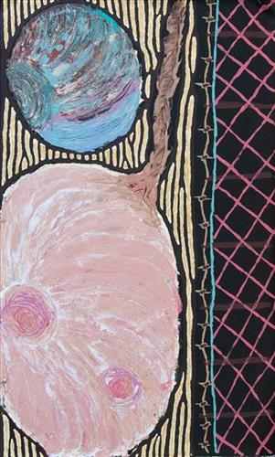
Tali, Tuwa (Sandhills)

The traditional lands of the Martu people encompass the Great Sandy Desert and Rudall River regions of Western Australia, an enormous tract dominated by distinctive red tali, or tuwa (sandhills). These sandhills present an unforgiving landscape; sparse vegetation covers a seemingly never ending expanse of dunes, and yet these lands and the location of resources within them was known intimately by its pujiman (traditional, desert dwelling) inhabitants. At this time, Martu traversed very large distances annually in small family groups, moving from water source to water source through the harsh desert landscape with incredible stamina and resourcefulness. Travel was often undertaken at night, and when travelling during the day, Martu wore yakipiri (woven bark sandals) to protect their feet from the hot desert sand.

111582299124


Untitled

This is Kumpaya’s Country- her ‘ngurra’ (home Country, camp). People identify with their ngurra in terms of specific rights and responsibilities, and the possession of intimate knowledge of the physical and cultural properties of one’s Country. Painting ngurra, and in so doing sharing the Jukurrpa (Dreaming) stories and physical characteristics of that place, has today become an important means of cultural maintenance. 

Kumpaya’s ngurra encompasses the Country that she and her family walked in the pujiman (traditional, desert-dwelling) era. At this time she travelled nomadically with her own and other family groups, traversing an enormous tract of land around the middle section of the Canning Stock Route, and between Punmu Aboriginal community and Kiwirrkura, more than 500 kilometres eastward. 

Kumpaya was born close to Kiwirrkurra, a rockhole located in the Gibson Desert and to the south west of Lake McKay. She grew up, walked and hunted primarily around this area. As a young woman Kumpaya travelled westward, through to Kunawarritji (Canning Stock Route Well 33). She continued to live nomadically before eventually deciding to move to Jigalong Mission along with many other relatives following an extreme and prolonged drought in the 1960s. 

Portrayed in this work are features of Kumpaya’s ngurra, such as the striking salt lakes, dominant permanent red tali (sandhills), warta (trees, vegetation), and the individually named water sources she and her family camped at. These include Luurnkurangu, Karingkarra , Katarta, Pinkari, Pintu-pintu, Yanjiwara, Kunalimpi, Juntu-juntu (Canning Stock Route Well 30), Warla-warla (Canning Stock Route Well 31), Kunawarritji, Kinyu (Canning Stock Route Well 35), Natawalu (Canning Stock Route Well 40), and Kupankurlu. Rock holes, waterholes, soaks and springs were all extremely important sites for Martu people during the pujiman period, and are generally depicted with circular forms. 

The encyclopaedic knowledge of the location, quality and seasonal availability of the hundreds of water bodies found in one’s Country sustained Martu as they travelled across their Country, hunting and gathering, visiting family, and fulfilling ceremonial obligations. They would traverse very large distances annually, visiting specific areas in the dry and wet season depending on the availability of water and the corresponding cycles of plant and animal life on which hunting and gathering bush tucker was reliant. As they travelled and hunted they would also burn areas of Country, generating a greater diversity of plant and animal life.