111582139253


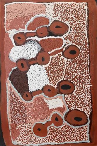
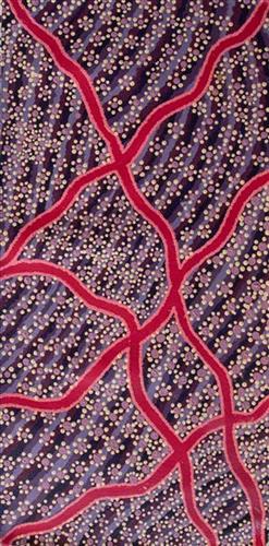
Engadine creek

“When Martu paint, it’s like a map. Martu draw story on the ground and on the canvas, and all the circle and line there are the hunting areas and different waters and tracks where people used to walk, and [some you] can’t cross, like boundaries. So nowadays you see a colourful painting and wonder what it is, but that’s how Martu tell story long ago. It’s not just a lovely painting, it’s a story and a songline and a history and everything that goes with it.” 

– Ngalangka Nola Taylor and Joshua Booth

This work portrays an area of Country that can be interpreted in multiple ways. Firstly, the image may be read as an aerial representation of a particular location known to the artist- either land that they or their family travelled, from the pujiman (traditional, desert dwelling) era to now. During the pujiman period, Martu would traverse very large distances annually in small family groups, moving seasonally from water source to water source, and hunting and gathering bush tucker as they went. At this time, one’s survival depended on their intimate knowledge of the location of resources; thus physical elements of Country, such as sources of kapi (water), tali (sandhills), different varieties of warta (trees, vegetation), ngarrini (camps), and jina (tracks) are typically recorded with the use of a use of a system of iconographic forms universally shared across the desert. 

An additional layer of meaning in the work relates to more intangible concepts; life cycles based around kalyu (rain, water) and waru (fire) are also often evident. A thousands of year old practice, fire burning continues to be carried out as both an aid for hunting and a means of land management today. As the Martu travelled and hunted they would burn tracts of land, ensuring plant and animal biodiversity and reducing the risk of unmanageable, spontaneous bush fires. The patchwork nature of regrowth is evident in many landscape works, with each of the five distinctive phases of fire burning visually described with respect to the cycle of burning and regrowth.  

Finally, metaphysical information relating to a location may also be recorded; Jukurrpa (Dreaming) narratives chronicle the creation of physical landmarks, and can be referenced through depictions of ceremonial sites, songlines, and markers left in the land. Very often, however, information relating to Jukurrpa is censored by omission, or alternatively painted over with dotted patterns.
111582139271


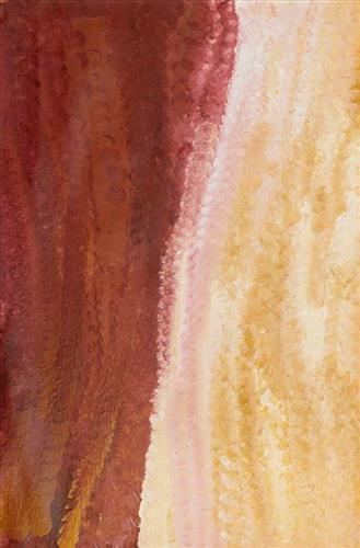
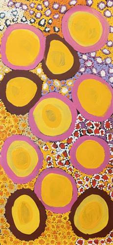
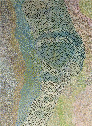
Nyurnma

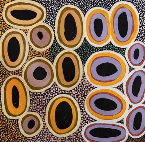
Martu artists paint Country in all it’s different seasonal stages. Important to Martu, and to Martu Country, is the practice of waru (fire burning); a practice that assists with hunting, regenerates growth, and encourages greater diversity in plant and animal life. When Martu Country burns, mosaic fire scars are left on the Country, and patches of regeneration form a kind of mosaic pattern across the land. This is called nyurnma – burnt Country.  Waru is typically burnt in small, controlled areas, leaving a defined patchwork pattern of nyurnma in the land, across tali (sand hills), linyji (clay pans), parulyukurru (spinifex country) and pila (sandy plains). This patterning is clearly visible in Martumili Artists works, where they paint Country from an aerial perspective.

111582139269


Untitled

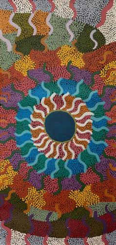
This work portrays an area known intimately to the artist, painted here in exquisite detail from memory. During the pujiman (traditional, desert dwelling) era one’s survival depended on their intimate knowledge of the location of resources; thus physical elements of Country, such as sources of kapi (water), tali (sandhills), and different varieties of warta (trees, vegetation) were carefully observed and remembered. Today, this relationship with Country remains equally strong, despite the movement of Martu out of the desert and into remote Aboriginal Communities, towns and cities.

Also visible may be traces of life cycles based around kalyu (rain, water) and waru (fire). A thousands of year old practice, fire burning continues to be carried out as both an aid for hunting and a means of land management today. As the Martu travelled and hunted they would burn tracts of land, ensuring plant and animal biodiversity and reducing the risk of unmanageable, spontaneous bush fires. The patchwork nature of regrowth is visible in many landscape works, with each of the five distinctive phases of fire burning visually described with respect to the cycle of burning and regrowth.  

Finally, metaphysical information relating to a location may also be recorded; Jukurrpa (Dreaming) narratives chronicle the creation of physical landmarks, and can be referenced through depictions of ceremonial sites, songlines, and markers left in the land. 

111582139267


Kulyakartu

“Long time ago I been there. It is my grandmother’s, grandfather’s, father’s, [and] mother’s country, Kulyakartu.  I am painting this particular place. It keeps me connected, [gives me a] sense of belonging [to] tell my grandmother’s story through my art.  Where she was born, I’m a part of that. 

It makes me feel proud painting.  Most important is telling the story behind the painting so people can understand where I am coming from.  Kulyakartu is our ngurra (home Country, camp).  I will continue telling the story through my art.”

– Derrick Butt

This painting depicts Kulyakartu, Derrick’s ancestral ngurra (home Country, camp). Kulyakartu is a large area in the far north of the Martu homelands, near the Percival Lakes region of Western Australia’s Great Sandy Desert. Kulyakartu is mostly flat grass Country, and is known as a good hunting area. In particular, parnajarrpa (goanna), wild cats, and lunki (witchetty grub) are found in abundance here. In the wantajarra (wet season) the dry lakes in the region fill with water.

111582140347


Pintu- Pintu – Kumpaya Girgaba

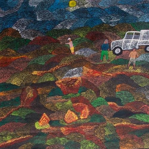
“We were at Pintu-pintu when all of a sudden we heard a rumbling noise like an earthquake. When I heard that noise, I set the little one down [her children] and saw for the first time a grader and there was a Toyota in the front. That whitefella [Len Beadell] had fruit, flour and tucker… He gave all the little kids fruit – apple, orange, tomato, plum, a whole sheep. The kids made the biggest waru (fire) for the fruit and cooked it. When they came back from playing games, they tried to take the fruit out of the fire because it should be cooked and [it] was all soggy and it had cooked away to nothing, there was nothing there to eat. That’s when they got picked up.”

 – Kumpaya Girgirba (Girgaba), as translated by Ngalangka Nola Taylor

Pintu-pintu is a rockhole located south east of Parnngurr Aboriginal community and within in the Mckay Range region. As Kumpaya here describes, this site is especially significant to her as the location where she first had direct contact with a whitefella, Len Beadell. He was surveying a testing range for an intercontinental ballistic missile called the Blue Streak, and graded a road from Woomera, in South Australia, to the Percival Lakes. In the process he encountered some of the last Martu still living in the desert. For them, the sight of Beadell’s bulldozers and graders churning up the Country evoked a frightening scene. Soon after this meeting she was picked up with her husband and children and another twenty or so Martu at nearby Parnngurr Rockhole by the Native Welfare Department. From there they were taken to Jigalong Mission. Collectively the group had come to the decision to move to the mission as a result of an extended drought, which had caused a scarcity in food and water resources. They also wanted to join their families, who had already moved to Jigalong.

111582140344


Parnngurr

“We were climbing Parnngurr hill; we were frightened. Kartiya (Europeans) would walk around, trying to catch Martu people. We would run up the hill and hide. We watched them catch people. We were eating flour that white people gave us. It was horrible. From [Parnngurr rockhole], we got in the truck and went with the white people to Jigalong. Kumpaya [Girgirba], Jakayu [Biljabu] and Ngamaru [Bidu], we were all on top of the hill looking at the white people.”

– Bugai Whyoulter


Parnngurr rockhole is located 370km east of Newman. This site lies within Bugai’s ngurra (home Country, camp), the area which she knew intimately and travelled extensively with her family in her youth. For many Martu, including Bugai, Parnngurr also signifies the location at which their nomadic bush life came to an end. Poignantly described here by Bugai, it was here that a group of 29 Martu were picked up by the Native Welfare Department to be taken to Jigalong Mission in 1963. Collectively the group had come to the decision to move to the mission as a result of an extended drought, which had caused a scarcity in food and water resources. The group also wanted to join their families, who had already moved to Jigalong.

At the junction of three linguistic groups; Manyjilyjarra, Kartujarra, and Warnman, Parnngurr rockhole was a critical and permanent source of water during the pujiman (traditional, desert born) era, supporting many ritual large gatherings. During this nomadic period families stopped and camped here depending on the seasonal availability of water and the corresponding cycles of plant and animal life on which hunting and gathering bush tucker was reliant. At Parnngurr and other similarly important camp sites families would meet for a time before moving to their next destination. Parnngurr rockhole and its surrounds are physically dominated by distinctively red tali (sandhills), covered sparingly with spinifex and low lying shrub. 

Parnngurr community, just north of Parnngurr rockhole, was created during the Return to Country movement of the 1980s, coinciding with the recognition of Aboriginal land rights and native title. The community was named after its’ original primary water source. Until recently the community was widely known as Cotton Creek, after the European name for the ephemeral creek running alongside the community.

111582140343


Pitu (Separation Well)

“I paint Pitu because my father come[s] from Pitu and all the rest of the family, they belong to there. Family hear the stories all the time from Jakayu [Biljabu]. It’s their connection to that place. All the old people were walking through that area, aunty Jakayu was born there. It’s a sad story, hers. We [went] there… to see it again. It’s a long, long way from Punmu. All the other family [saw] where their family is from and where they belong to.”


–       Kuru Gladys Bidu


Pitu (Separation Well) forms part of Kuru’s ngurra (home Country, camp) through her father. It is a significant cultural site and large soak located yulparirra (south) of Wuranu (Canning Stock Route Well 29) and Kulilu rockhole and soak. As a site where fresh water was available all year, Pitu was an important camp and a meeting place for Kartujarra and Manyjilyjarra people during the pujiman (traditional, desert dwelling) era. At this time, knowledge of water sources was critical for survival, and today Martu Country is still defined in terms of the location and type of water. Each of the hundreds of claypans, rockholes, waterholes, soaks and springs found in the Martu desert homelands is known by name, location, quality and seasonal availability through real life experience and the recounting of Jukurrpa (Dreaming) narratives. 


Soaks, or soakwaters, derive their name from the manner in which their waters generally seep into the sand from below stores, sometimes as part of an ephemeral river or creek. Soaks were an especially important source of water during the pujiman era, being the most dependable water source in times of drought. Water was obtained from soaks by scooping away the sand with a piti (timber bowls used for carrying food and water) until clear water gathered at the base of the hole, sometimes at a depth of several metres. Pitu is also surrounded by shrubs that need to be cleared to access its waters.

111582140342


Pitu (Separation Well)

“I paint Pitu because my father come[s] from Pitu and all the rest of the family, they belong to there. Family hear the stories all the time from Jakayu [Biljabu]. It’s their connection to that place. All the old people were walking through that area, aunty Jakayu was born there. It’s a sad story, hers. We [went] there… to see it again. It’s a long, long way from Punmu. All the other family [saw] where their family is from and where they belong to.”


–       Kuru Gladys Bidu


Pitu (Separation Well) forms part of Kuru’s ngurra (home Country, camp) through her father. It is a significant cultural site and large soak located yulparirra (south) of Wuranu (Canning Stock Route Well 29) and Kulilu rockhole and soak. As a site where fresh water was available all year, Pitu was an important camp and a meeting place for Kartujarra and Manyjilyjarra people during the pujiman (traditional, desert dwelling) era. At this time, knowledge of water sources was critical for survival, and today Martu Country is still defined in terms of the location and type of water. Each of the hundreds of claypans, rockholes, waterholes, soaks and springs found in the Martu desert homelands is known by name, location, quality and seasonal availability through real life experience and the recounting of Jukurrpa (Dreaming) narratives. 


Soaks, or soakwaters, derive their name from the manner in which their waters generally seep into the sand from below stores, sometimes as part of an ephemeral river or creek. Soaks were an especially important source of water during the pujiman era, being the most dependable water source in times of drought. Water was obtained from soaks by scooping away the sand with a piti (timber bowls used for carrying food and water) until clear water gathered at the base of the hole, sometimes at a depth of several metres. Pitu is also surrounded by shrubs that need to be cleared to access its waters.

111582140341


Pitu (Separation Well)

“I paint Pitu because my father come[s] from Pitu and all the rest of the family, they belong to there. Family hear the stories all the time from Jakayu [Biljabu]. It’s their connection to that place. All the old people were walking through that area, aunty Jakayu was born there. It’s a sad story, hers. We [went] there… to see it again. It’s a long, long way from Punmu. All the other family [saw] where their family is from and where they belong to.”


–       Kuru Gladys Bidu


Pitu (Separation Well) forms part of Kuru’s ngurra (home Country, camp) through her father. It is a significant cultural site and large soak located yulparirra (south) of Wuranu (Canning Stock Route Well 29) and Kulilu rockhole and soak. As a site where fresh water was available all year, Pitu was an important camp and a meeting place for Kartujarra and Manyjilyjarra people during the pujiman (traditional, desert dwelling) era. At this time, knowledge of water sources was critical for survival, and today Martu Country is still defined in terms of the location and type of water. Each of the hundreds of claypans, rockholes, waterholes, soaks and springs found in the Martu desert homelands is known by name, location, quality and seasonal availability through real life experience and the recounting of Jukurrpa (Dreaming) narratives. 


Soaks, or soakwaters, derive their name from the manner in which their waters generally seep into the sand from below stores, sometimes as part of an ephemeral river or creek. Soaks were an especially important source of water during the pujiman era, being the most dependable water source in times of drought. Water was obtained from soaks by scooping away the sand with a piti (timber bowls used for carrying food and water) until clear water gathered at the base of the hole, sometimes at a depth of several metres. Pitu is also surrounded by shrubs that need to be cleared to access its waters.

111582140340


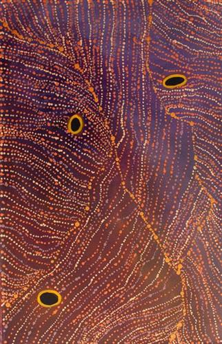
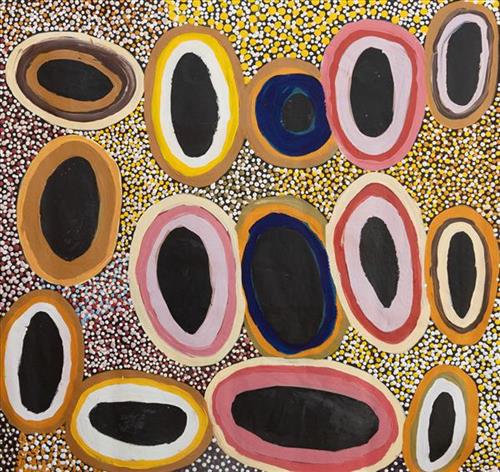
Waterhole

This work depicts a waterhole within the artists’ ngurra (home Country, camp), typically represented with circular forms. Waterholes are sites that require maintenance, including digging to increase flow, clearing out surrounding growth, and cleaning up after sullying by camels or cattle.

During the pujiman (traditional, desert dwelling) period, knowledge of water sources was critical for survival, and today Martu Country is still defined in terms of the location and type of water. Each of the hundreds of claypans, rockholes, waterholes, soaks and springs found in the Martu desert homelands is known through real life experience and the recounting of Jukurrpa (Dreaming) narratives by name, location, quality and seasonal availability. This encyclopedic knowledge extends even to the nature and movement of arterial waterways, and sustained Martu as they travelled across their Country, hunting and gathering, visiting family, and fulfilling ceremonial obligations. They would traverse very large distances annually, visiting specific areas in the dry and wet season depending on the availability of water and the corresponding cycles of plant and animal life on which hunting and gathering bush tucker was reliant.