111582069523


Untitled

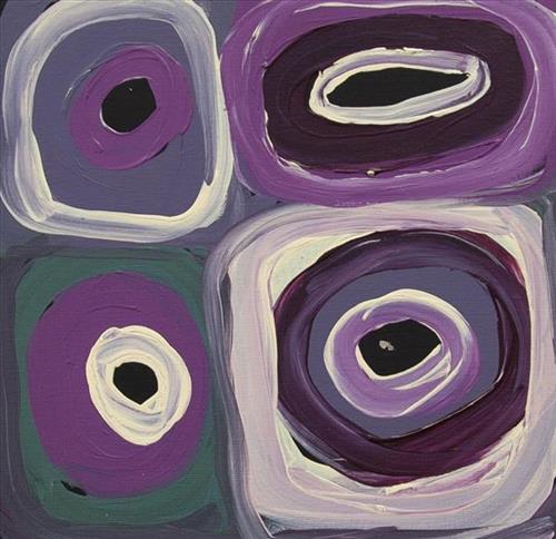
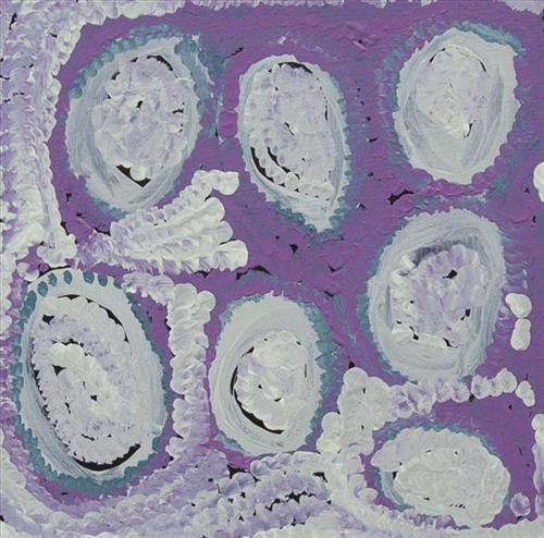
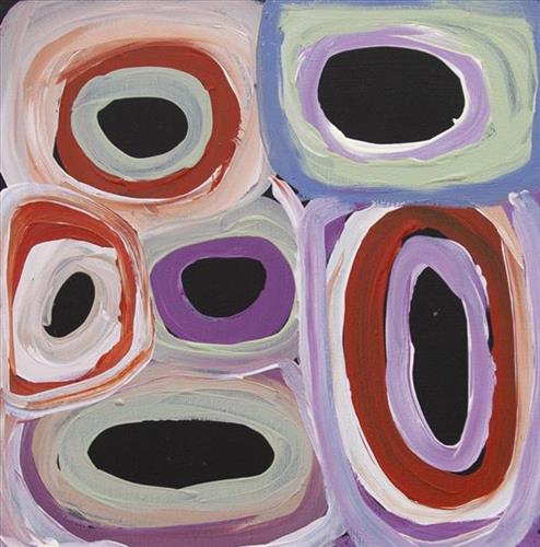
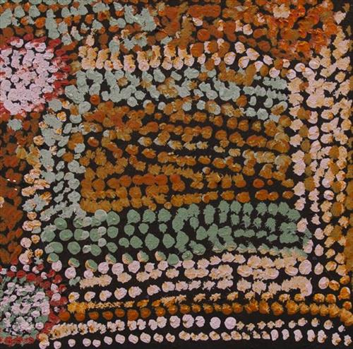
“When Martu paint, it’s like a map. Martu draw story on the ground and on the canvas, and all the circle and line there are the hunting areas and different waters and tracks where people used to walk, and [some you] can’t cross, like boundaries. So nowadays you see a colourful painting and wonder what it is, but that’s how Martu tell story long ago. It’s not just a lovely painting, it’s a story and a songline and a history and everything that goes with it.” 

– Ngalangka Nola Taylor and Joshua Booth

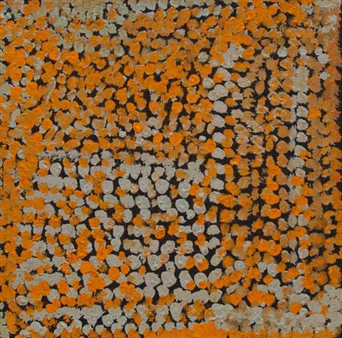
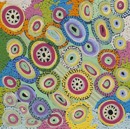
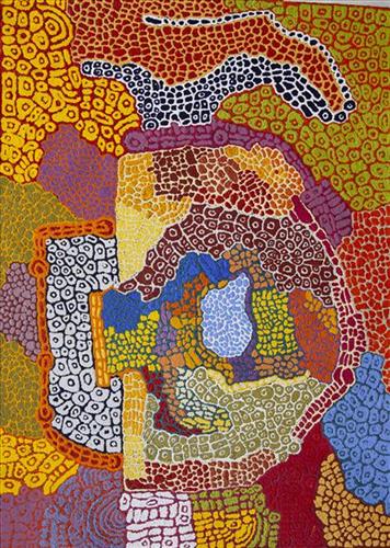
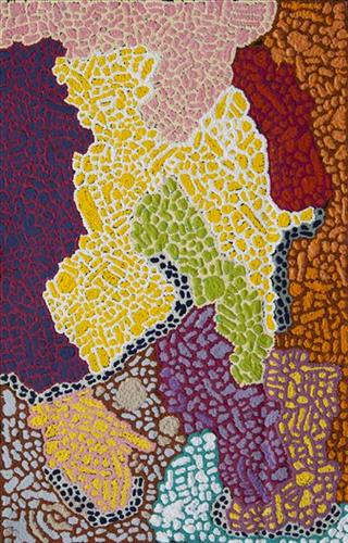
This work portrays an area of Country that can be interpreted in multiple ways. Firstly, the image may be read as an aerial representation of a particular location known to the artist- either land that they or their family travelled, from the pujiman (traditional, desert dwelling) era to now. During the pujiman period, Martu would traverse very large distances annually in small family groups, moving seasonally from water source to water source, and hunting and gathering bush tucker as they went. At this time, one’s survival depended on their intimate knowledge of the location of resources; thus physical elements of Country, such as sources of kapi (water), tali (sandhills), different varieties of warta (trees, vegetation), ngarrini (camps), and jina (tracks) are typically recorded with the use of a use of a system of iconographic forms universally shared across the desert. 

An additional layer of meaning in the work relates to more intangible concepts; life cycles based around kalyu (rain, water) and waru (fire) are also often evident. A thousands of year old practice, fire burning continues to be carried out as both an aid for hunting and a means of land management today. As the Martu travelled and hunted they would burn tracts of land, ensuring plant and animal biodiversity and reducing the risk of unmanageable, spontaneous bush fires. The patchwork nature of regrowth is evident in many landscape works, with each of the five distinctive phases of fire burning visually described with respect to the cycle of burning and regrowth.  

Finally, metaphysical information relating to a location may also be recorded; Jukurrpa (Dreaming) narratives chronicle the creation of physical landmarks, and can be referenced through depictions of ceremonial sites, songlines, and markers left in the land. Very often, however, information relating to Jukurrpa is censored by omission, or alternatively painted over with dotted patterns.
111582069520


Untitled

“When Martu paint, it’s like a map. Martu draw story on the ground and on the canvas, and all the circle and line there are the hunting areas and different waters and tracks where people used to walk, and [some you] can’t cross, like boundaries. So nowadays you see a colourful painting and wonder what it is, but that’s how Martu tell story long ago. It’s not just a lovely painting, it’s a story and a songline and a history and everything that goes with it.” 

– Ngalangka Nola Taylor and Joshua Booth

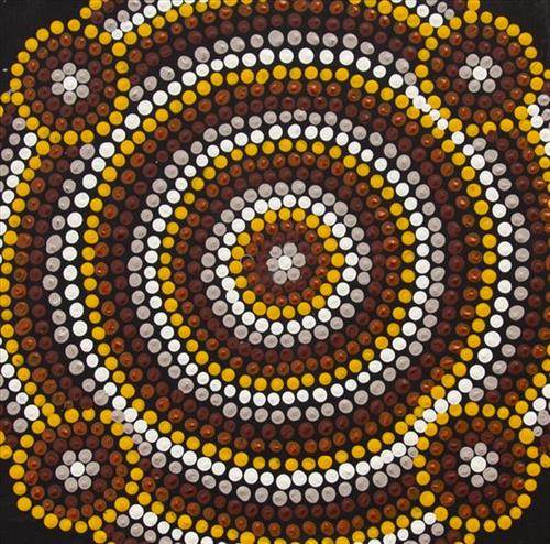
This work portrays an area of Country that can be interpreted in multiple ways. Firstly, the image may be read as an aerial representation of a particular location known to the artist- either land that they or their family travelled, from the pujiman (traditional, desert dwelling) era to now. During the pujiman period, Martu would traverse very large distances annually in small family groups, moving seasonally from water source to water source, and hunting and gathering bush tucker as they went. At this time, one’s survival depended on their intimate knowledge of the location of resources; thus physical elements of Country, such as sources of kapi (water), tali (sandhills), different varieties of warta (trees, vegetation), ngarrini (camps), and jina (tracks) are typically recorded with the use of a use of a system of iconographic forms universally shared across the desert. 

An additional layer of meaning in the work relates to more intangible concepts; life cycles based around kalyu (rain, water) and waru (fire) are also often evident. A thousands of year old practice, fire burning continues to be carried out as both an aid for hunting and a means of land management today. As the Martu travelled and hunted they would burn tracts of land, ensuring plant and animal biodiversity and reducing the risk of unmanageable, spontaneous bush fires. The patchwork nature of regrowth is evident in many landscape works, with each of the five distinctive phases of fire burning visually described with respect to the cycle of burning and regrowth.  

Finally, metaphysical information relating to a location may also be recorded; Jukurrpa (Dreaming) narratives chronicle the creation of physical landmarks, and can be referenced through depictions of ceremonial sites, songlines, and markers left in the land. Very often, however, information relating to Jukurrpa is censored by omission, or alternatively painted over with dotted patterns.
111582069516


Untitled

“When Martu paint, it’s like a map. Martu draw story on the ground and on the canvas, and all the circle and line there are the hunting areas and different waters and tracks where people used to walk, and [some you] can’t cross, like boundaries. So nowadays you see a colourful painting and wonder what it is, but that’s how Martu tell story long ago. It’s not just a lovely painting, it’s a story and a songline and a history and everything that goes with it.” 

– Ngalangka Nola Taylor and Joshua Booth

This work portrays an area of Country that can be interpreted in multiple ways. Firstly, the image may be read as an aerial representation of a particular location known to the artist- either land that they or their family travelled, from the pujiman (traditional, desert dwelling) era to now. During the pujiman period, Martu would traverse very large distances annually in small family groups, moving seasonally from water source to water source, and hunting and gathering bush tucker as they went. At this time, one’s survival depended on their intimate knowledge of the location of resources; thus physical elements of Country, such as sources of kapi (water), tali (sandhills), different varieties of warta (trees, vegetation), ngarrini (camps), and jina (tracks) are typically recorded with the use of a use of a system of iconographic forms universally shared across the desert. 

An additional layer of meaning in the work relates to more intangible concepts; life cycles based around kalyu (rain, water) and waru (fire) are also often evident. A thousands of year old practice, fire burning continues to be carried out as both an aid for hunting and a means of land management today. As the Martu travelled and hunted they would burn tracts of land, ensuring plant and animal biodiversity and reducing the risk of unmanageable, spontaneous bush fires. The patchwork nature of regrowth is evident in many landscape works, with each of the five distinctive phases of fire burning visually described with respect to the cycle of burning and regrowth.  

Finally, metaphysical information relating to a location may also be recorded; Jukurrpa (Dreaming) narratives chronicle the creation of physical landmarks, and can be referenced through depictions of ceremonial sites, songlines, and markers left in the land. Very often, however, information relating to Jukurrpa is censored by omission, or alternatively painted over with dotted patterns.
111582071718


Untitled

“This is my Country. My little brother was born here in pujiman (traditional, desert-dwelling) times. I was a big girl, no man yet. We were walking a long way.”

– Nyanjilpayi (Ngarnjapayi) Nancy Chapman


“When I was born my spirit appeared at Jarntinti. That’s my Country, Jarntinti. I was born a pujiman in Tarl Country. I know all about it, about that water over there, about my home, our grandparent’s Country. We travelled all around as pujiman, camping and then setting off again by foot. We didn’t get tired. We just kept on going. Sometimes it would rain, so we would build a shelter, just like a tent. Inside we would light a fire. Our pujiman lifestyle was very healthy and we didn’t get sick very often. Even when it was cold we continued to walk around in good health. Living on our Country we feel fulfilled. We know how to live here because we are pujiman.

I feel deeply satisfied, really well. It’s really good. I’m working on my painting of those waterholes, I was drinking from them long ago as a pujiman. My family’s water, my grandmother’s, my grandfathers and my ancestors. I was taught from them. Our knowledge is ancient and has been passed on by our grandparents. Young people need to keep looking after it. Our home is where our ancestors walked around. They knew how to care for it. Now we are teaching the younger generation. Now they have the knowledge of the water places. We are telling them they need to keep visiting these water places that we have taken them to and shown them properly. They need to keep visiting them after we have passed away. They need to continue our legacy and look after our Country, our grandparent’s Country.

– Nyanjilpayi Nancy Chapman, as translated by Kanyirninpa Jukurrpa


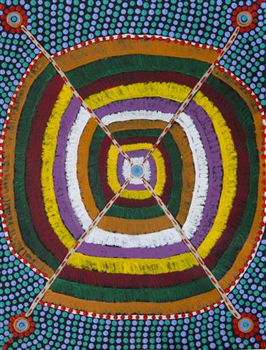
This is Nyanjilpayi’s Country- her ‘ngurra’ (home Country, camp). People identify with their ngurra in terms of specific rights and responsibilities, and the possession of intimate knowledge of the physical and cultural properties of one’s Country. Painting ngurra, and in so doing sharing the Jukurrpa (Dreaming) stories and physical characteristics of that place, has today become an important means of cultural maintenance. 

Nyanjilpayi’s ngurra encompasses the Country that she and her family walked in the pujiman  era. Nyanjilpayi was born at Jarntinti, a large claypan at the southern end of Nyayartakujarra (Lake Dora) and within the Karlamilyi (Rudall River) region. She grew up, walked and hunted primarily around the Country extending across the Punmu, Kunawarritji (Canning Stock Route Well 33) and Karlamilyi (Rudall River) regions. Following the death of both their parents, Nyanjilpayi and her sisters travelled alone between Punmu and Kunawarritji, occasionally meeting with other family groups. They continued to live nomadically before eventually deciding to move to Jigalong Mission along with many other relatives following an extreme and prolonged drought in the 1960s. 

Portrayed in this work are features of Nyanjilpayi’s ngurra, such as the dominant permanent red tali (sandhills), warta (trees, vegetation), and the individually named water sources she and her family camped at. These include Jarntinti, Yaralalu, Januwa, Jilankujarra, Karlajarntu, Kartungu, Kularti, Kumpupajanu, Kunalimpi, Kunarra, Marnakarti, Pangkapirni, Wilunganinya, Wurur-wururna, Yilyara, and Yirrajarra. Rock holes, waterholes, soaks and springs were all extremely important sites for Martu people during the pujiman period, and are generally depicted with circular forms.  

The encyclopaedic knowledge of the location, quality and seasonal availability of the hundreds of water bodies found in one’s Country sustained Martu as they travelled across their Country, hunting and gathering, visiting family, and fulfilling ceremonial obligations. They would traverse very large distances annually, visiting specific areas in the dry and wet season depending on the availability of water and the corresponding cycles of plant and animal life on which hunting and gathering bush tucker was reliant. As they travelled and hunted they would also burn areas of Country, generating a greater diversity of plant and animal life.

111582071715


Untitled

“When Martu paint, it’s like a map. Martu draw story on the ground and on the canvas, and all the circle and line there are the hunting areas and different waters and tracks where people used to walk, and [some you] can’t cross, like boundaries. So nowadays you see a colourful painting and wonder what it is, but that’s how Martu tell story long ago. It’s not just a lovely painting, it’s a story and a songline and a history and everything that goes with it.” 

– Ngalangka Nola Taylor and Joshua Booth

This work portrays an area of Country that can be interpreted in multiple ways. Firstly, the image may be read as an aerial representation of a particular location known to the artist- either land that they or their family travelled, from the pujiman (traditional, desert dwelling) era to now. During the pujiman period, Martu would traverse very large distances annually in small family groups, moving seasonally from water source to water source, and hunting and gathering bush tucker as they went. At this time, one’s survival depended on their intimate knowledge of the location of resources; thus physical elements of Country, such as sources of kapi (water), tali (sandhills), different varieties of warta (trees, vegetation), ngarrini (camps), and jina (tracks) are typically recorded with the use of a use of a system of iconographic forms universally shared across the desert. 

An additional layer of meaning in the work relates to more intangible concepts; life cycles based around kalyu (rain, water) and waru (fire) are also often evident. A thousands of year old practice, fire burning continues to be carried out as both an aid for hunting and a means of land management today. As the Martu travelled and hunted they would burn tracts of land, ensuring plant and animal biodiversity and reducing the risk of unmanageable, spontaneous bush fires. The patchwork nature of regrowth is evident in many landscape works, with each of the five distinctive phases of fire burning visually described with respect to the cycle of burning and regrowth.  

Finally, metaphysical information relating to a location may also be recorded; Jukurrpa (Dreaming) narratives chronicle the creation of physical landmarks, and can be referenced through depictions of ceremonial sites, songlines, and markers left in the land. Very often, however, information relating to Jukurrpa is censored by omission, or alternatively painted over with dotted patterns.
111582071714


Pitu  (Separation Well)

“I paint Pitu because my father come from Pitu and all the rest of the family, they belong to there. Family hear the stories all the time from Jakayu (Biljabu) it’s there connection to that place. All the old people were walking through that area, aunty Jakayu was born there. It’s a sad story hers. We going there this year (2021), to see it again it’s a long long way from Punmu. All the other family are going to see where their family is from and where they belong too.”

–       Gladys Bidu (Kuru)

Pitu (Separation Well) is an important cultural site and large soak located yulparirra (south) of Wuranu (Canning Stock Route Well 29) and Kulilu rockhole and soak. As a site where fresh water was available all year, Pitu was an important camp and a meeting place for Kartujarra and Manyjilyjarra people during the pujiman (traditional, desert dwelling) era. At this time, knowledge of water sources was critical for survival, and today Martu Country is still defined in terms of the location and type of water. Each of the hundreds of claypans, rockholes, waterholes, soaks and springs found in the Martu desert homelands is known by name, location, quality and seasonal availability through real life experience and the recounting of Jukurrpa (Dreaming) narratives. 
Soaks, or soakwaters, derive their name from the manner in which their waters generally seep into the sand from below stores, sometimes as part of an ephemeral river or creek. Soaks were an especially important source of water during the pujiman era, being the most dependable water source in times of drought. Water was obtained from soaks by scooping away the sand with a piti (timber bowls used for carrying food and water) until clear water gathered at the base of the hole, sometimes at a depth of several metres. Pitu is also surrounded by shrubs that need to be cleared to access its waters


111582071710


Untitled

“This is my Country. My little brother was born here in pujiman (traditional, desert-dwelling) times. I was a big girl, no man yet. We were walking a long way.”

– Nyanjilpayi (Ngarnjapayi) Nancy Chapman


“When I was born my spirit appeared at Jarntinti. That’s my Country, Jarntinti. I was born a pujiman in Tarl Country. I know all about it, about that water over there, about my home, our grandparent’s Country. We travelled all around as pujiman, camping and then setting off again by foot. We didn’t get tired. We just kept on going. Sometimes it would rain, so we would build a shelter, just like a tent. Inside we would light a fire. Our pujiman lifestyle was very healthy and we didn’t get sick very often. Even when it was cold we continued to walk around in good health. Living on our Country we feel fulfilled. We know how to live here because we are pujiman.

I feel deeply satisfied, really well. It’s really good. I’m working on my painting of those waterholes, I was drinking from them long ago as a pujiman. My family’s water, my grandmother’s, my grandfathers and my ancestors. I was taught from them. Our knowledge is ancient and has been passed on by our grandparents. Young people need to keep looking after it. Our home is where our ancestors walked around. They knew how to care for it. Now we are teaching the younger generation. Now they have the knowledge of the water places. We are telling them they need to keep visiting these water places that we have taken them to and shown them properly. They need to keep visiting them after we have passed away. They need to continue our legacy and look after our Country, our grandparent’s Country.

– Nyanjilpayi Nancy Chapman, as translated by Kanyirninpa Jukurrpa


This is Nyanjilpayi’s Country- her ‘ngurra’ (home Country, camp). People identify with their ngurra in terms of specific rights and responsibilities, and the possession of intimate knowledge of the physical and cultural properties of one’s Country. Painting ngurra, and in so doing sharing the Jukurrpa (Dreaming) stories and physical characteristics of that place, has today become an important means of cultural maintenance. 

Nyanjilpayi’s ngurra encompasses the Country that she and her family walked in the pujiman  era. Nyanjilpayi was born at Jarntinti, a large claypan at the southern end of Nyayartakujarra (Lake Dora) and within the Karlamilyi (Rudall River) region. She grew up, walked and hunted primarily around the Country extending across the Punmu, Kunawarritji (Canning Stock Route Well 33) and Karlamilyi (Rudall River) regions. Following the death of both their parents, Nyanjilpayi and her sisters travelled alone between Punmu and Kunawarritji, occasionally meeting with other family groups. They continued to live nomadically before eventually deciding to move to Jigalong Mission along with many other relatives following an extreme and prolonged drought in the 1960s. 

Portrayed in this work are features of Nyanjilpayi’s ngurra, such as the dominant permanent red tali (sandhills), warta (trees, vegetation), and the individually named water sources she and her family camped at. These include Jarntinti, Yaralalu, Januwa, Jilankujarra, Karlajarntu, Kartungu, Kularti, Kumpupajanu, Kunalimpi, Kunarra, Marnakarti, Pangkapirni, Wilunganinya, Wurur-wururna, Yilyara, and Yirrajarra. Rock holes, waterholes, soaks and springs were all extremely important sites for Martu people during the pujiman period, and are generally depicted with circular forms.  

The encyclopaedic knowledge of the location, quality and seasonal availability of the hundreds of water bodies found in one’s Country sustained Martu as they travelled across their Country, hunting and gathering, visiting family, and fulfilling ceremonial obligations. They would traverse very large distances annually, visiting specific areas in the dry and wet season depending on the availability of water and the corresponding cycles of plant and animal life on which hunting and gathering bush tucker was reliant. As they travelled and hunted they would also burn areas of Country, generating a greater diversity of plant and animal life.

111582071709


Pitu  (Separation Well)

“I paint Pitu because my father come from Pitu and all the rest of the family, they belong to there. Family hear the stories all the time from Jakayu (Biljabu) it’s there connection to that place. All the old people were walking through that area, aunty Jakayu was born there. It’s a sad story hers. We going there this year (2021), to see it again it’s a long long way from Punmu. All the other family are going to see where their family is from and where they belong too.”

–       Gladys Bidu (Kuru)

Pitu (Separation Well) is an important cultural site and large soak located yulparirra (south) of Wuranu (Canning Stock Route Well 29) and Kulilu rockhole and soak. As a site where fresh water was available all year, Pitu was an important camp and a meeting place for Kartujarra and Manyjilyjarra people during the pujiman (traditional, desert dwelling) era. At this time, knowledge of water sources was critical for survival, and today Martu Country is still defined in terms of the location and type of water. Each of the hundreds of claypans, rockholes, waterholes, soaks and springs found in the Martu desert homelands is known by name, location, quality and seasonal availability through real life experience and the recounting of Jukurrpa (Dreaming) narratives. 
Soaks, or soakwaters, derive their name from the manner in which their waters generally seep into the sand from below stores, sometimes as part of an ephemeral river or creek. Soaks were an especially important source of water during the pujiman era, being the most dependable water source in times of drought. Water was obtained from soaks by scooping away the sand with a piti (timber bowls used for carrying food and water) until clear water gathered at the base of the hole, sometimes at a depth of several metres. Pitu is also surrounded by shrubs that need to be cleared to access its waters


111582071708


Untitled

“This is my Country. My little brother was born here in pujiman (traditional, desert-dwelling) times. I was a big girl, no man yet. We were walking a long way.”

– Nyanjilpayi (Ngarnjapayi) Nancy Chapman


“When I was born my spirit appeared at Jarntinti. That’s my Country, Jarntinti. I was born a pujiman in Tarl Country. I know all about it, about that water over there, about my home, our grandparent’s Country. We travelled all around as pujiman, camping and then setting off again by foot. We didn’t get tired. We just kept on going. Sometimes it would rain, so we would build a shelter, just like a tent. Inside we would light a fire. Our pujiman lifestyle was very healthy and we didn’t get sick very often. Even when it was cold we continued to walk around in good health. Living on our Country we feel fulfilled. We know how to live here because we are pujiman.

I feel deeply satisfied, really well. It’s really good. I’m working on my painting of those waterholes, I was drinking from them long ago as a pujiman. My family’s water, my grandmother’s, my grandfathers and my ancestors. I was taught from them. Our knowledge is ancient and has been passed on by our grandparents. Young people need to keep looking after it. Our home is where our ancestors walked around. They knew how to care for it. Now we are teaching the younger generation. Now they have the knowledge of the water places. We are telling them they need to keep visiting these water places that we have taken them to and shown them properly. They need to keep visiting them after we have passed away. They need to continue our legacy and look after our Country, our grandparent’s Country.

– Nyanjilpayi Nancy Chapman, as translated by Kanyirninpa Jukurrpa


This is Nyanjilpayi’s Country- her ‘ngurra’ (home Country, camp). People identify with their ngurra in terms of specific rights and responsibilities, and the possession of intimate knowledge of the physical and cultural properties of one’s Country. Painting ngurra, and in so doing sharing the Jukurrpa (Dreaming) stories and physical characteristics of that place, has today become an important means of cultural maintenance. 

Nyanjilpayi’s ngurra encompasses the Country that she and her family walked in the pujiman  era. Nyanjilpayi was born at Jarntinti, a large claypan at the southern end of Nyayartakujarra (Lake Dora) and within the Karlamilyi (Rudall River) region. She grew up, walked and hunted primarily around the Country extending across the Punmu, Kunawarritji (Canning Stock Route Well 33) and Karlamilyi (Rudall River) regions. Following the death of both their parents, Nyanjilpayi and her sisters travelled alone between Punmu and Kunawarritji, occasionally meeting with other family groups. They continued to live nomadically before eventually deciding to move to Jigalong Mission along with many other relatives following an extreme and prolonged drought in the 1960s. 

Portrayed in this work are features of Nyanjilpayi’s ngurra, such as the dominant permanent red tali (sandhills), warta (trees, vegetation), and the individually named water sources she and her family camped at. These include Jarntinti, Yaralalu, Januwa, Jilankujarra, Karlajarntu, Kartungu, Kularti, Kumpupajanu, Kunalimpi, Kunarra, Marnakarti, Pangkapirni, Wilunganinya, Wurur-wururna, Yilyara, and Yirrajarra. Rock holes, waterholes, soaks and springs were all extremely important sites for Martu people during the pujiman period, and are generally depicted with circular forms.  

The encyclopaedic knowledge of the location, quality and seasonal availability of the hundreds of water bodies found in one’s Country sustained Martu as they travelled across their Country, hunting and gathering, visiting family, and fulfilling ceremonial obligations. They would traverse very large distances annually, visiting specific areas in the dry and wet season depending on the availability of water and the corresponding cycles of plant and animal life on which hunting and gathering bush tucker was reliant. As they travelled and hunted they would also burn areas of Country, generating a greater diversity of plant and animal life.

111582071707


Untitled

“When Martu paint, it’s like a map. Martu draw story on the ground and on the canvas, and all the circle and line there are the hunting areas and different waters and tracks where people used to walk, and [some you] can’t cross, like boundaries. So nowadays you see a colourful painting and wonder what it is, but that’s how Martu tell story long ago. It’s not just a lovely painting, it’s a story and a songline and a history and everything that goes with it.” 

– Ngalangka Nola Taylor and Joshua Booth

This work portrays an area of Country that can be interpreted in multiple ways. Firstly, the image may be read as an aerial representation of a particular location known to the artist- either land that they or their family travelled, from the pujiman (traditional, desert dwelling) era to now. During the pujiman period, Martu would traverse very large distances annually in small family groups, moving seasonally from water source to water source, and hunting and gathering bush tucker as they went. At this time, one’s survival depended on their intimate knowledge of the location of resources; thus physical elements of Country, such as sources of kapi (water), tali (sandhills), different varieties of warta (trees, vegetation), ngarrini (camps), and jina (tracks) are typically recorded with the use of a use of a system of iconographic forms universally shared across the desert. 

An additional layer of meaning in the work relates to more intangible concepts; life cycles based around kalyu (rain, water) and waru (fire) are also often evident. A thousands of year old practice, fire burning continues to be carried out as both an aid for hunting and a means of land management today. As the Martu travelled and hunted they would burn tracts of land, ensuring plant and animal biodiversity and reducing the risk of unmanageable, spontaneous bush fires. The patchwork nature of regrowth is evident in many landscape works, with each of the five distinctive phases of fire burning visually described with respect to the cycle of burning and regrowth.  

Finally, metaphysical information relating to a location may also be recorded; Jukurrpa (Dreaming) narratives chronicle the creation of physical landmarks, and can be referenced through depictions of ceremonial sites, songlines, and markers left in the land. Very often, however, information relating to Jukurrpa is censored by omission, or alternatively painted over with dotted patterns.