11154001049


Status: Stock


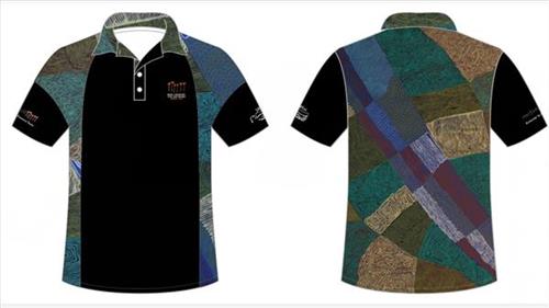
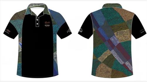
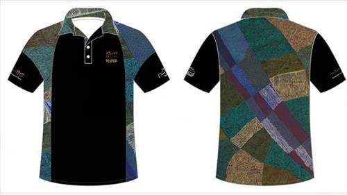
‘Karlamilyi’ 2021 NAIDOC Tshirt

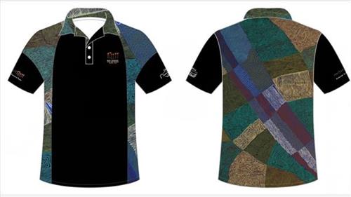
“This is in the Karlamilyi River (Rudall River) area. The sand dunes run from the East to the West and stop at the river’s edge on each side. Where the sand dunes stop, the river was created by the Jila Kujarra (Two Snakes) that went east to Nyayartakujarra (Ngayarta Kujarra, Lake Dora). 

North of Karlamilyi River there’s a series of claypans in that Country, big claypans and small claypans. After it’s rained they all get filled up. Walyji (white gum) grows around the claypans. It’s a camping area for Warnman people. They used to get water there and also from the Karlamilyi River area. 

You can see that blue water along the Karlamilyi River, and the red tuwa (sandhills). As you fly over that Country you will see the designs on the ground in the different formations and colours. That’s the land of my family who are the ancestral owners of Karlamilyi.” 

 – Desmond Taylor 

Karlamilyi is Warnman Country, located in the very heart of the Martu homelands. The Karlamilyi region is Desmond’s ngurra (home Country, camp) through his parents and grandparents, and he possesses a great deal of knowledge of the region’s physical elements, resource distribution, and Jukurrpa (Dreaming) narratives.

The region is situated southwest of the Great Sandy Desert and northeast of the Little Sandy Desert. Spanning through the region is the epic Karlamilyi River, which runs north into Nyayartakujarra, a large salt lake. The Broadhurst and Fingoon Ranges extend diagonally across the river’s path. The landscape is striking for its abundance of gorges and valleys carved by ice age glaciers, rugged cliffs, red tali (sand dunes), grasslands, sandstone and quartz rocky outcrops, and salt lakes. 

Across the whole region are hundreds of water sources; including waterholes, creeks, soaks, lakes, pools and rockholes. Lining the rivers are coolabah, walyji (river gum), yulbah (bats wing coral tree), and several species of acacia and hakea. Jalkuran (paperbark), kurrulyu/ mijarrpa (bloodwood) and jawirli (quandong) are found in the region’s valleys, and wikirrpa (desert oaks) and grasses in the sandplains. The area is abundant with bird species, jila (snakes), maruntu (goannas), red kangaroos and warlpaju (rock wallabies). The region is also home to remote aboriginal communities Punmu and Parnngurr.

According to two of the central Martu Jukurrpa narratives, the Karlamilyi River and its surrounds were created by the ancestral beings Jila Kujarra and the Wati Kujarra (Two Goanna Men) as they travelled across the lands.

11154001048


Status: Stock


‘Karlamilyi’ 2021 NAIDOC Tshirt

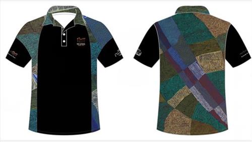
“This is in the Karlamilyi River (Rudall River) area. The sand dunes run from the East to the West and stop at the river’s edge on each side. Where the sand dunes stop, the river was created by the Jila Kujarra (Two Snakes) that went east to Nyayartakujarra (Ngayarta Kujarra, Lake Dora). 

North of Karlamilyi River there’s a series of claypans in that Country, big claypans and small claypans. After it’s rained they all get filled up. Walyji (white gum) grows around the claypans. It’s a camping area for Warnman people. They used to get water there and also from the Karlamilyi River area. 

You can see that blue water along the Karlamilyi River, and the red tuwa (sandhills). As you fly over that Country you will see the designs on the ground in the different formations and colours. That’s the land of my family who are the ancestral owners of Karlamilyi.” 

 – Desmond Taylor 

Karlamilyi is Warnman Country, located in the very heart of the Martu homelands. The Karlamilyi region is Desmond’s ngurra (home Country, camp) through his parents and grandparents, and he possesses a great deal of knowledge of the region’s physical elements, resource distribution, and Jukurrpa (Dreaming) narratives.

The region is situated southwest of the Great Sandy Desert and northeast of the Little Sandy Desert. Spanning through the region is the epic Karlamilyi River, which runs north into Nyayartakujarra, a large salt lake. The Broadhurst and Fingoon Ranges extend diagonally across the river’s path. The landscape is striking for its abundance of gorges and valleys carved by ice age glaciers, rugged cliffs, red tali (sand dunes), grasslands, sandstone and quartz rocky outcrops, and salt lakes. 

Across the whole region are hundreds of water sources; including waterholes, creeks, soaks, lakes, pools and rockholes. Lining the rivers are coolabah, walyji (river gum), yulbah (bats wing coral tree), and several species of acacia and hakea. Jalkuran (paperbark), kurrulyu/ mijarrpa (bloodwood) and jawirli (quandong) are found in the region’s valleys, and wikirrpa (desert oaks) and grasses in the sandplains. The area is abundant with bird species, jila (snakes), maruntu (goannas), red kangaroos and warlpaju (rock wallabies). The region is also home to remote aboriginal communities Punmu and Parnngurr.

According to two of the central Martu Jukurrpa narratives, the Karlamilyi River and its surrounds were created by the ancestral beings Jila Kujarra and the Wati Kujarra (Two Goanna Men) as they travelled across the lands.

11154001047


Status: Stock


‘Karlamilyi’ 2021 NAIDOC Tshirt

“This is in the Karlamilyi River (Rudall River) area. The sand dunes run from the East to the West and stop at the river’s edge on each side. Where the sand dunes stop, the river was created by the Jila Kujarra (Two Snakes) that went east to Nyayartakujarra (Ngayarta Kujarra, Lake Dora). 

North of Karlamilyi River there’s a series of claypans in that Country, big claypans and small claypans. After it’s rained they all get filled up. Walyji (white gum) grows around the claypans. It’s a camping area for Warnman people. They used to get water there and also from the Karlamilyi River area. 

You can see that blue water along the Karlamilyi River, and the red tuwa (sandhills). As you fly over that Country you will see the designs on the ground in the different formations and colours. That’s the land of my family who are the ancestral owners of Karlamilyi.” 

 – Desmond Taylor 

Karlamilyi is Warnman Country, located in the very heart of the Martu homelands. The Karlamilyi region is Desmond’s ngurra (home Country, camp) through his parents and grandparents, and he possesses a great deal of knowledge of the region’s physical elements, resource distribution, and Jukurrpa (Dreaming) narratives.

The region is situated southwest of the Great Sandy Desert and northeast of the Little Sandy Desert. Spanning through the region is the epic Karlamilyi River, which runs north into Nyayartakujarra, a large salt lake. The Broadhurst and Fingoon Ranges extend diagonally across the river’s path. The landscape is striking for its abundance of gorges and valleys carved by ice age glaciers, rugged cliffs, red tali (sand dunes), grasslands, sandstone and quartz rocky outcrops, and salt lakes. 

Across the whole region are hundreds of water sources; including waterholes, creeks, soaks, lakes, pools and rockholes. Lining the rivers are coolabah, walyji (river gum), yulbah (bats wing coral tree), and several species of acacia and hakea. Jalkuran (paperbark), kurrulyu/ mijarrpa (bloodwood) and jawirli (quandong) are found in the region’s valleys, and wikirrpa (desert oaks) and grasses in the sandplains. The area is abundant with bird species, jila (snakes), maruntu (goannas), red kangaroos and warlpaju (rock wallabies). The region is also home to remote aboriginal communities Punmu and Parnngurr.

According to two of the central Martu Jukurrpa narratives, the Karlamilyi River and its surrounds were created by the ancestral beings Jila Kujarra and the Wati Kujarra (Two Goanna Men) as they travelled across the lands.
11154001046


Status: Stock


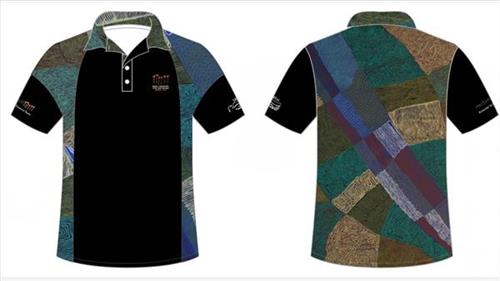
‘Karlamilyi’ 2021 NAIDOC Tshirt

“This is in the Karlamilyi River (Rudall River) area. The sand dunes run from the East to the West and stop at the river’s edge on each side. Where the sand dunes stop, the river was created by the Jila Kujarra (Two Snakes) that went east to Nyayartakujarra (Ngayarta Kujarra, Lake Dora). 

North of Karlamilyi River there’s a series of claypans in that Country, big claypans and small claypans. After it’s rained they all get filled up. Walyji (white gum) grows around the claypans. It’s a camping area for Warnman people. They used to get water there and also from the Karlamilyi River area. 

You can see that blue water along the Karlamilyi River, and the red tuwa (sandhills). As you fly over that Country you will see the designs on the ground in the different formations and colours. That’s the land of my family who are the ancestral owners of Karlamilyi.” 

 – Desmond Taylor 

Karlamilyi is Warnman Country, located in the very heart of the Martu homelands. The Karlamilyi region is Desmond’s ngurra (home Country, camp) through his parents and grandparents, and he possesses a great deal of knowledge of the region’s physical elements, resource distribution, and Jukurrpa (Dreaming) narratives.

The region is situated southwest of the Great Sandy Desert and northeast of the Little Sandy Desert. Spanning through the region is the epic Karlamilyi River, which runs north into Nyayartakujarra, a large salt lake. The Broadhurst and Fingoon Ranges extend diagonally across the river’s path. The landscape is striking for its abundance of gorges and valleys carved by ice age glaciers, rugged cliffs, red tali (sand dunes), grasslands, sandstone and quartz rocky outcrops, and salt lakes. 

Across the whole region are hundreds of water sources; including waterholes, creeks, soaks, lakes, pools and rockholes. Lining the rivers are coolabah, walyji (river gum), yulbah (bats wing coral tree), and several species of acacia and hakea. Jalkuran (paperbark), kurrulyu/ mijarrpa (bloodwood) and jawirli (quandong) are found in the region’s valleys, and wikirrpa (desert oaks) and grasses in the sandplains. The area is abundant with bird species, jila (snakes), maruntu (goannas), red kangaroos and warlpaju (rock wallabies). The region is also home to remote aboriginal communities Punmu and Parnngurr.

According to two of the central Martu Jukurrpa narratives, the Karlamilyi River and its surrounds were created by the ancestral beings Jila Kujarra and the Wati Kujarra (Two Goanna Men) as they travelled across the lands.

11154001045


Status: Stock


‘Karlamilyi’ 2021 NAIDOC Tshirt

“This is in the Karlamilyi River (Rudall River) area. The sand dunes run from the East to the West and stop at the river’s edge on each side. Where the sand dunes stop, the river was created by the Jila Kujarra (Two Snakes) that went east to Nyayartakujarra (Ngayarta Kujarra, Lake Dora). 

North of Karlamilyi River there’s a series of claypans in that Country, big claypans and small claypans. After it’s rained they all get filled up. Walyji (white gum) grows around the claypans. It’s a camping area for Warnman people. They used to get water there and also from the Karlamilyi River area. 

You can see that blue water along the Karlamilyi River, and the red tuwa (sandhills). As you fly over that Country you will see the designs on the ground in the different formations and colours. That’s the land of my family who are the ancestral owners of Karlamilyi.” 

 – Desmond Taylor 

Karlamilyi is Warnman Country, located in the very heart of the Martu homelands. The Karlamilyi region is Desmond’s ngurra (home Country, camp) through his parents and grandparents, and he possesses a great deal of knowledge of the region’s physical elements, resource distribution, and Jukurrpa (Dreaming) narratives.

The region is situated southwest of the Great Sandy Desert and northeast of the Little Sandy Desert. Spanning through the region is the epic Karlamilyi River, which runs north into Nyayartakujarra, a large salt lake. The Broadhurst and Fingoon Ranges extend diagonally across the river’s path. The landscape is striking for its abundance of gorges and valleys carved by ice age glaciers, rugged cliffs, red tali (sand dunes), grasslands, sandstone and quartz rocky outcrops, and salt lakes. 

Across the whole region are hundreds of water sources; including waterholes, creeks, soaks, lakes, pools and rockholes. Lining the rivers are coolabah, walyji (river gum), yulbah (bats wing coral tree), and several species of acacia and hakea. Jalkuran (paperbark), kurrulyu/ mijarrpa (bloodwood) and jawirli (quandong) are found in the region’s valleys, and wikirrpa (desert oaks) and grasses in the sandplains. The area is abundant with bird species, jila (snakes), maruntu (goannas), red kangaroos and warlpaju (rock wallabies). The region is also home to remote aboriginal communities Punmu and Parnngurr.

According to two of the central Martu Jukurrpa narratives, the Karlamilyi River and its surrounds were created by the ancestral beings Jila Kujarra and the Wati Kujarra (Two Goanna Men) as they travelled across the lands.

11154001044


Status: Stock


‘Karlamilyi’ 2021 NAIDOC Tshirt

“This is in the Karlamilyi River (Rudall River) area. The sand dunes run from the East to the West and stop at the river’s edge on each side. Where the sand dunes stop, the river was created by the Jila Kujarra (Two Snakes) that went east to Nyayartakujarra (Ngayarta Kujarra, Lake Dora). 

North of Karlamilyi River there’s a series of claypans in that Country, big claypans and small claypans. After it’s rained they all get filled up. Walyji (white gum) grows around the claypans. It’s a camping area for Warnman people. They used to get water there and also from the Karlamilyi River area. 

You can see that blue water along the Karlamilyi River, and the red tuwa (sandhills). As you fly over that Country you will see the designs on the ground in the different formations and colours. That’s the land of my family who are the ancestral owners of Karlamilyi.” 

 – Desmond Taylor 

Karlamilyi is Warnman Country, located in the very heart of the Martu homelands. The Karlamilyi region is Desmond’s ngurra (home Country, camp) through his parents and grandparents, and he possesses a great deal of knowledge of the region’s physical elements, resource distribution, and Jukurrpa (Dreaming) narratives.

The region is situated southwest of the Great Sandy Desert and northeast of the Little Sandy Desert. Spanning through the region is the epic Karlamilyi River, which runs north into Nyayartakujarra, a large salt lake. The Broadhurst and Fingoon Ranges extend diagonally across the river’s path. The landscape is striking for its abundance of gorges and valleys carved by ice age glaciers, rugged cliffs, red tali (sand dunes), grasslands, sandstone and quartz rocky outcrops, and salt lakes. 

Across the whole region are hundreds of water sources; including waterholes, creeks, soaks, lakes, pools and rockholes. Lining the rivers are coolabah, walyji (river gum), yulbah (bats wing coral tree), and several species of acacia and hakea. Jalkuran (paperbark), kurrulyu/ mijarrpa (bloodwood) and jawirli (quandong) are found in the region’s valleys, and wikirrpa (desert oaks) and grasses in the sandplains. The area is abundant with bird species, jila (snakes), maruntu (goannas), red kangaroos and warlpaju (rock wallabies). The region is also home to remote aboriginal communities Punmu and Parnngurr.

According to two of the central Martu Jukurrpa narratives, the Karlamilyi River and its surrounds were created by the ancestral beings Jila Kujarra and the Wati Kujarra (Two Goanna Men) as they travelled across the lands.

11154001043


Status: Stock


‘Karlamilyi’ 2021 NAIDOC Tshirt

“This is in the Karlamilyi River (Rudall River) area. The sand dunes run from the East to the West and stop at the river’s edge on each side. Where the sand dunes stop, the river was created by the Jila Kujarra (Two Snakes) that went east to Nyayartakujarra (Ngayarta Kujarra, Lake Dora). 

North of Karlamilyi River there’s a series of claypans in that Country, big claypans and small claypans. After it’s rained they all get filled up. Walyji (white gum) grows around the claypans. It’s a camping area for Warnman people. They used to get water there and also from the Karlamilyi River area. 

You can see that blue water along the Karlamilyi River, and the red tuwa (sandhills). As you fly over that Country you will see the designs on the ground in the different formations and colours. That’s the land of my family who are the ancestral owners of Karlamilyi.” 

 – Desmond Taylor 

Karlamilyi is Warnman Country, located in the very heart of the Martu homelands. The Karlamilyi region is Desmond’s ngurra (home Country, camp) through his parents and grandparents, and he possesses a great deal of knowledge of the region’s physical elements, resource distribution, and Jukurrpa (Dreaming) narratives.

The region is situated southwest of the Great Sandy Desert and northeast of the Little Sandy Desert. Spanning through the region is the epic Karlamilyi River, which runs north into Nyayartakujarra, a large salt lake. The Broadhurst and Fingoon Ranges extend diagonally across the river’s path. The landscape is striking for its abundance of gorges and valleys carved by ice age glaciers, rugged cliffs, red tali (sand dunes), grasslands, sandstone and quartz rocky outcrops, and salt lakes. 

Across the whole region are hundreds of water sources; including waterholes, creeks, soaks, lakes, pools and rockholes. Lining the rivers are coolabah, walyji (river gum), yulbah (bats wing coral tree), and several species of acacia and hakea. Jalkuran (paperbark), kurrulyu/ mijarrpa (bloodwood) and jawirli (quandong) are found in the region’s valleys, and wikirrpa (desert oaks) and grasses in the sandplains. The area is abundant with bird species, jila (snakes), maruntu (goannas), red kangaroos and warlpaju (rock wallabies). The region is also home to remote aboriginal communities Punmu and Parnngurr.

According to two of the central Martu Jukurrpa narratives, the Karlamilyi River and its surrounds were created by the ancestral beings Jila Kujarra and the Wati Kujarra (Two Goanna Men) as they travelled across the lands.
11154001042


Status: Stock


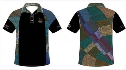
‘Karlamilyi’ 2021 NAIDOC Tshirt

“This is in the Karlamilyi River (Rudall River) area. The sand dunes run from the East to the West and stop at the river’s edge on each side. Where the sand dunes stop, the river was created by the Jila Kujarra (Two Snakes) that went east to Nyayartakujarra (Ngayarta Kujarra, Lake Dora). 

North of Karlamilyi River there’s a series of claypans in that Country, big claypans and small claypans. After it’s rained they all get filled up. Walyji (white gum) grows around the claypans. It’s a camping area for Warnman people. They used to get water there and also from the Karlamilyi River area. 

You can see that blue water along the Karlamilyi River, and the red tuwa (sandhills). As you fly over that Country you will see the designs on the ground in the different formations and colours. That’s the land of my family who are the ancestral owners of Karlamilyi.” 

 – Desmond Taylor 

Karlamilyi is Warnman Country, located in the very heart of the Martu homelands. The Karlamilyi region is Desmond’s ngurra (home Country, camp) through his parents and grandparents, and he possesses a great deal of knowledge of the region’s physical elements, resource distribution, and Jukurrpa (Dreaming) narratives.

The region is situated southwest of the Great Sandy Desert and northeast of the Little Sandy Desert. Spanning through the region is the epic Karlamilyi River, which runs north into Nyayartakujarra, a large salt lake. The Broadhurst and Fingoon Ranges extend diagonally across the river’s path. The landscape is striking for its abundance of gorges and valleys carved by ice age glaciers, rugged cliffs, red tali (sand dunes), grasslands, sandstone and quartz rocky outcrops, and salt lakes. 

Across the whole region are hundreds of water sources; including waterholes, creeks, soaks, lakes, pools and rockholes. Lining the rivers are coolabah, walyji (river gum), yulbah (bats wing coral tree), and several species of acacia and hakea. Jalkuran (paperbark), kurrulyu/ mijarrpa (bloodwood) and jawirli (quandong) are found in the region’s valleys, and wikirrpa (desert oaks) and grasses in the sandplains. The area is abundant with bird species, jila (snakes), maruntu (goannas), red kangaroos and warlpaju (rock wallabies). The region is also home to remote aboriginal communities Punmu and Parnngurr.

According to two of the central Martu Jukurrpa narratives, the Karlamilyi River and its surrounds were created by the ancestral beings Jila Kujarra and the Wati Kujarra (Two Goanna Men) as they travelled across the lands.

11153999663


Status: Stock


Emu Tracks to Puntawarri

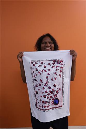
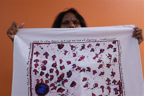
What Now?  T- Shirt is a graphic taken from Judith Anya Samson’s painting Emu Tracks to Puntawarri

“Emu go to the springs to have a drink of water and then move on to the next one.”

– Judith Anya Samson

Puntawarri is an important cultural area, as well as the site of a now abandoned community, a waterhole, creek and lake. Puntawarri is located on the middle stretches of the Canning Stock Route and east of the Jigalong Aboriginal Community, where Judith grew up with her grandmother and senior Martumili Artist Dadda Samson. Both artists continue to live there today.

Puntawarri lies within Judith’s ngurra (home Country, camp) through her mother’s family, and as a young girl she frequently travelled and hunted with her family in this area, learning the stories for this Country. Depicted in this work are the tracks of a group of emus on their way to Puntawarri waterhole, searching for kapi (water). 

Karlaya (emu) were traditionally hunted during the pujiman (traditional, desert dwelling) era, and they continue to be a favoured bush tucker for Martu today. During the pujiman (traditional, desert dwelling) period, Martu would traverse very large distances annually in small family groups, moving seasonally from water source to water source, and hunting and gathering bush tucker as they went. Jina (tracks, footprints) are used by Martu people when tracking bush tucker. In the absence of an actual animal sighting, tracks act as an identifier that an animal was present, which can then be followed to the animal’s present location. Besides providing information on location, Martu are able to interpret from tracks the passage of time since the tracks were imprinted, as well as the corresponding animal species and its size.

The softer and more extensive the ground surface, the easier it is to locate and follow tracks, thus certain conditions are favoured for tracking. Tuulparra (spring) and yalijarra (hot time) are preferred over wantajarra (winter), when south easterly tradewinds blow strongly to obscure tracks. Tracks and burrows are also more readily visible in early growth lands, such as nyurnma (freshly burnt Country) and waru-waru (growth of new shoots and young plants). For this reason, fire burning is an important tool in animal tracking. Small burns are lit to clear vegetation, expose burrows, and to allow for access to walk and track readily in exposed sands, while simultaneously providing diverse regenerating habitats.

11153999606


Status: Stock


Emu Tracks to Puntawarri

“Emu go to the springs to have a drink of water and then move on to the next one.”

– Judith Anya Samson

Puntawarri is an important cultural area, as well as the site of a now abandoned community, a waterhole, creek and lake. Puntawarri is located on the middle stretches of the Canning Stock Route and east of the Jigalong Aboriginal Community, where Judith grew up with her grandmother and senior Martumili Artist Dadda Samson. Both artists continue to live there today.

Puntawarri lies within Judith’s ngurra (home Country, camp) through her mother’s family, and as a young girl she frequently travelled and hunted with her family in this area, learning the stories for this Country. Depicted in this work are the tracks of a group of emus on their way to Puntawarri waterhole, searching for kapi (water). 

Karlaya (emu) were traditionally hunted during the pujiman (traditional, desert dwelling) era, and they continue to be a favoured bush tucker for Martu today. During the pujiman (traditional, desert dwelling) period, Martu would traverse very large distances annually in small family groups, moving seasonally from water source to water source, and hunting and gathering bush tucker as they went. Jina (tracks, footprints) are used by Martu people when tracking bush tucker. In the absence of an actual animal sighting, tracks act as an identifier that an animal was present, which can then be followed to the animal’s present location. Besides providing information on location, Martu are able to interpret from tracks the passage of time since the tracks were imprinted, as well as the corresponding animal species and its size.

The softer and more extensive the ground surface, the easier it is to locate and follow tracks, thus certain conditions are favoured for tracking. Tuulparra (spring) and yalijarra (hot time) are preferred over wantajarra (winter), when south easterly tradewinds blow strongly to obscure tracks. Tracks and burrows are also more readily visible in early growth lands, such as nyurnma (freshly burnt Country) and waru-waru (growth of new shoots and young plants). For this reason, fire burning is an important tool in animal tracking. Small burns are lit to clear vegetation, expose burrows, and to allow for access to walk and track readily in exposed sands, while simultaneously providing diverse regenerating habitats.