111581994249


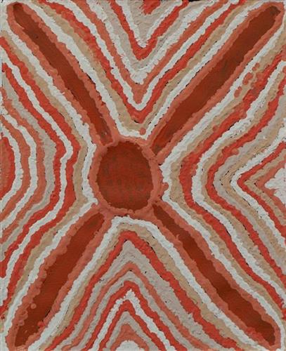
Waterholes

This work depicts waterholes within the artists’ ngurra (home Country, camp), typically represented with circular forms. Waterholes are sites that require maintenance, including digging to increase flow, clearing out surrounding growth, and cleaning up after sullying by camels or cattle.

During the pujiman (traditional, desert dwelling) period, knowledge of water sources was critical for survival, and today Martu Country is still defined in terms of the location and type of water. Each of the hundreds of claypans, rockholes, waterholes, soaks and springs found in the Martu desert homelands is known through real life experience and the recounting of Jukurrpa (Dreaming) narratives by name, location, quality and seasonal availability. This encyclopedic knowledge extends even to the nature and movement of arterial waterways, and sustained Martu as they travelled across their Country, hunting and gathering, visiting family, and fulfilling ceremonial obligations. They would traverse very large distances annually, visiting specific areas in the dry and wet season depending on the availability of water and the corresponding cycles of plant and animal life on which hunting and gathering bush tucker was reliant.

111581994248


Waterholes

This work depicts waterholes within the artists’ ngurra (home Country, camp), typically represented with circular forms. Waterholes are sites that require maintenance, including digging to increase flow, clearing out surrounding growth, and cleaning up after sullying by camels or cattle.

During the pujiman (traditional, desert dwelling) period, knowledge of water sources was critical for survival, and today Martu Country is still defined in terms of the location and type of water. Each of the hundreds of claypans, rockholes, waterholes, soaks and springs found in the Martu desert homelands is known through real life experience and the recounting of Jukurrpa (Dreaming) narratives by name, location, quality and seasonal availability. This encyclopedic knowledge extends even to the nature and movement of arterial waterways, and sustained Martu as they travelled across their Country, hunting and gathering, visiting family, and fulfilling ceremonial obligations. They would traverse very large distances annually, visiting specific areas in the dry and wet season depending on the availability of water and the corresponding cycles of plant and animal life on which hunting and gathering bush tucker was reliant.

111581994223


Kinyu (Canning Stock Route Well 35), Kunawarritji Jarntu (Dog)

“In pujiman (traditional, desert dwelling) time there were giant jarntu (dogs) walking around Kunawarritji (Canning Stock Route Well 33). Like I can see you, you can see me, real life those jarntu showed themselves. Those jarntu would go under ground. Under the parna (ground, earth). There was a male and female dog. The wanti (woman, girl) jarntu was juri (beautiful, good) one. The male jarntu wanted to be nyupa nyupa (partners). The wanti jarntu say, no, paki (nothing). The male jarntu was young and claimed that female jarntu.”

– Kumpaya Girgirba as translated by Ignatius Taylor

Kinyu (Canning Stock Route Well 35) is a small yinta (permanent spring) that was a popular camping site during the pujiman (traditional, desert dwelling) era. Kinyu forms part of Kumpaya’s ngurra (home Country, camp), the area which she knew intimately and travelled extensively with her family in her youth.

As alluded to in Kumpaya’s account, the site is home to the ancestral mother dingo, a generous provider and fierce protector of her Martu countrymen. Kinyu is so revered that the site and its associated ancestral being are often deferentially called jarntu in place of uttering the actual name. The site is believed to possess healing and magical powers, and children born here are said to inherit these same powers. 

During the Jukurrpa (Dreaming), Kinyu was the home for a family of dingoes; a mother, father, and their litter of pups. Originally the family had travelled to Wirlarra, following the call of the moon. At Wirlarra the moon cared for them and created a windbreak for the family to shelter. The dingoes stayed for a time at Wirlarra, scratching into the earth to create several distinctive small salt water pools which are still visited by the Martu for their healing properties. After a time, the dingoes continued travelling eastward toward the rising moon until they reached Kinyu, where they remained until all of the dingo pups had grown up. From Kinyu the family travelled further east. 

The intersection of the Canning Stock Route with Kinyu also made this a site of early contact with Europeans for many Martu then living a pujiman life in the desert. Following the route’s construction, Martu encountered Europeans and other Martu working as cattle drovers as they would travel up and down the Stock Route from water source to water source. Increasingly, pujimanpa (desert dwellers) followed the route to newly established ration depots, mission and pastoral stations. They were drawn to the route in search of food, by a sense of curiosity, or by loneliness. By the late 1950s and early 1960s, most of the desert family groups had left the desert. Eventually, these factors combined with an extreme and prolonged drought in the 1960s to prompt the few remaining pujimanpa to move in from the desert.

111581994220


Untitled

“When Martu paint, it’s like a map. Martu draw story on the ground and on the canvas, and all the circle and line there are the hunting areas and different waters and tracks where people used to walk, and [some you] can’t cross, like boundaries. So nowadays you see a colourful painting and wonder what it is, but that’s how Martu tell story long ago. It’s not just a lovely painting, it’s a story and a songline and a history and everything that goes with it.” 

– Ngalangka Nola Taylor and Joshua Booth

This work portrays an area of Country that can be interpreted in multiple ways. Firstly, the image may be read as an aerial representation of a particular location known to the artist- either land that they or their family travelled, from the pujiman (traditional, desert dwelling) era to now. During the pujiman period, Martu would traverse very large distances annually in small family groups, moving seasonally from water source to water source, and hunting and gathering bush tucker as they went. At this time, one’s survival depended on their intimate knowledge of the location of resources; thus physical elements of Country, such as sources of kapi (water), tali (sandhills), different varieties of warta (trees, vegetation), ngarrini (camps), and jina (tracks) are typically recorded with the use of a use of a system of iconographic forms universally shared across the desert. 

An additional layer of meaning in the work relates to more intangible concepts; life cycles based around kalyu (rain, water) and waru (fire) are also often evident. A thousands of year old practice, fire burning continues to be carried out as both an aid for hunting and a means of land management today. As the Martu travelled and hunted they would burn tracts of land, ensuring plant and animal biodiversity and reducing the risk of unmanageable, spontaneous bush fires. The patchwork nature of regrowth is evident in many landscape works, with each of the five distinctive phases of fire burning visually described with respect to the cycle of burning and regrowth.  

Finally, metaphysical information relating to a location may also be recorded; Jukurrpa (Dreaming) narratives chronicle the creation of physical landmarks, and can be referenced through depictions of ceremonial sites, songlines, and markers left in the land. Very often, however, information relating to Jukurrpa is censored by omission, or alternatively painted over with dotted patterns.

111581994254


Untitled

“When Martu paint, it’s like a map. Martu draw story on the ground and on the canvas, and all the circle and line there are the hunting areas and different waters and tracks where people used to walk, and [some you] can’t cross, like boundaries. So nowadays you see a colourful painting and wonder what it is, but that’s how Martu tell story long ago. It’s not just a lovely painting, it’s a story and a songline and a history and everything that goes with it.” 

– Ngalangka Nola Taylor and Joshua Booth

This work portrays an area of Country that can be interpreted in multiple ways. Firstly, the image may be read as an aerial representation of a particular location known to the artist- either land that they or their family travelled, from the pujiman (traditional, desert dwelling) era to now. During the pujiman period, Martu would traverse very large distances annually in small family groups, moving seasonally from water source to water source, and hunting and gathering bush tucker as they went. At this time, one’s survival depended on their intimate knowledge of the location of resources; thus physical elements of Country, such as sources of kapi (water), tali (sandhills), different varieties of warta (trees, vegetation), ngarrini (camps), and jina (tracks) are typically recorded with the use of a use of a system of iconographic forms universally shared across the desert. 

An additional layer of meaning in the work relates to more intangible concepts; life cycles based around kalyu (rain, water) and waru (fire) are also often evident. A thousands of year old practice, fire burning continues to be carried out as both an aid for hunting and a means of land management today. As the Martu travelled and hunted they would burn tracts of land, ensuring plant and animal biodiversity and reducing the risk of unmanageable, spontaneous bush fires. The patchwork nature of regrowth is evident in many landscape works, with each of the five distinctive phases of fire burning visually described with respect to the cycle of burning and regrowth.  

Finally, metaphysical information relating to a location may also be recorded; Jukurrpa (Dreaming) narratives chronicle the creation of physical landmarks, and can be referenced through depictions of ceremonial sites, songlines, and markers left in the land. Very often, however, information relating to Jukurrpa is censored by omission, or alternatively painted over with dotted patterns.

111581994253


Untitled

This is Dale’s Country- her ‘ngurra’ (home Country, camp). People identify with their ngurra in terms of specific rights and responsibilities, and the possession of intimate knowledge of the physical and cultural properties of one’s Country. Painting ngurra, and in so doing sharing the Jukurrpa (Dreaming) stories and physical characteristics of that place, has today become an important means of cultural maintenance. Dale’s ngurra encompasses her birthplace, Jigalong, and the Country that her family walked in the pujiman (traditional, desert-dwelling) era, including Puntawarri, Raarki (Canning Stock Route Well 27), Kularti, Kumpupirntily , Mirtikanya, (Kumpupintily, Lake Disappointment), and Mukurtu.

Portrayed in this work are features of Dale’s family’s ngurra, such as the striking salt lakes, dominant permanent red tali (sandhills), warta (trees, vegetation), and the individually named water sources they camped at. Rock holes, waterholes, soaks and springs were all extremely important sites for Martu people during the pujiman period, and are generally depicted with circular forms. 

The encyclopaedic knowledge of the location, quality and seasonal availability of the hundreds of water bodies found in one’s Country sustained Martu as they travelled across their Country, hunting and gathering, visiting family, and fulfilling ceremonial obligations. They would traverse very large distances annually, visiting specific areas in the dry and wet season depending on the availability of water and the corresponding cycles of plant and animal life on which hunting and gathering bush tucker was reliant. As they travelled and hunted they would also burn areas of Country, generating a greater diversity of plant and animal life.

111581994241


Kulyakartu

“My Country, Kulyakartu. I grew up there, from little boy to big boy grew up there.”

 – Muuki Taylor

This painting depicts Kulyakartu, Muuki’s ngurra (home Country, camp). Kulyakartu is located in the far north of the Martu homelands, near the Percival Lakes region of Western Australia’s Great Sandy Desert. Muuki has extensive knowledge of the Country in this region, where he grew up living traditionally during the pujiman (traditional, desert dwelling) days with his family. Kulyakartu is mostly grass Country where there is very good hunting. In particular parnajarrpa (goanna), wild cats, and lunki (witchetty grub) are found in abundance here. There is no permanent water source in Kulyakartu, so Muuki’s family would walk here annually following the wantajarra (wet season). During the yalijarra (hot, dry season) they would head south again to more permanent water.

Muuki paints Kulyakartu in all its different seasonal stages. Often visible in his work is the patchwork nature of regrowth subsequent to the practice of waru (fire) burning that assists with hunting, regenerates growth, and encourages greater diversity in plant and animal life. This mosaic patterning is aligned with the five distinct Martu cyclical phases of burning and regrowth. First is nyurnma (freshly burnt Country) when Muuki is “making waru”. Following nyurnma are the rains and subsequent waru-waru, when young, bright green plants start to grow. Nyukura occurs between one and three years after burning, when plants have matured and are fruiting and seeding. Manguu is “when him finished”, four to six years post burning, and when spinifex has matured to the point that it can be burned once again. Finally, kunarka signifies the time when spinifex and other plant species have become old growth, and pose a risk of destructive bushfires.

111581994239


Old Jigalong

“This one here. Yeah. That’s Jigalong. I’ve been there. I was working there. That’s good, this one here. Stories, yeah? This one here. I was painting in Jigalong. This one’s the cars. The cars. And the houses in Jigalong. And then the sandhills, lakes. That’s the lake [points to top right-hand corner]. The lake here and the green trees, and the sandhills. We going out working, you know? We going out working to Jigalong. All the ladies, we go out. All the ladies. Yeah that’s the one, all the ladies. We work choppers. Yeah I’ve been there in Jigalong with my mum and dad long time. And the cars. We go out in that. We go out working. We just work around Jigalong, the ladies.”

– Helen Dale Samson

Jigalong Aboriginal Community, the largest of the Martu communities, is located on the western edge of the Little Sandy Desert, not far from the town of Newman. Jigalong was established in 1907 as the site for a maintenance and rations store for workmen constructing the Rabbit Proof Fence, and converted to a camel breeding site in the 1930’s before finally becoming a Christian mission under the Apostolic Church in 1947. The land was returned to the Martu in 1974. 

For many Martu, Jigalong Mission was the site where their pujiman (traditional, desert dwelling) lifestyle came to an end from the late 1940s as they transitioned to a life as stockmen and women working in cattle stations in the Pilbara region and beyond. In the wake of the extreme and prolonged drought of the 1960s, the last of the remaining pujimanpa (desert dwellers) were forced to move to missions like Jigalong, where a supply of food and water was assured. There, many Martu were reunited with family members that had already moved in from the desert. 

Old Jigalong is where the camp on Jigalong Station was situated before the present Community was built. Dale grew up here, but would frequently camp with her family on Country during weekends. Helen Dale continues to live in Jigalong today.

111581994238


Mirtikanya (Mujupunkanu, Watchpoint Hill)

“This one here is Watchpoint Hill near to Jigalong, with all the sandhills and the walyji (white gums). We got warla (lakes) there too. Jigalong is where I grew up.”

 – Helen Dale Simpson

Mirtikanya is a hill and claypan close to Balfour Downs Station and north of Jigalong Aboriginal community, where Dale continues to live today. During the pujiman (traditional, desert dwelling) era, Mintikanya was primarily used as a camping site in the wantajarra (wet season), when the claypan filled with kapi (water).

Mirtikanya’s location close to Jigalong Mission made it a popular camping site for mission residents on the weekend. For many Martu Jigalong Mission was where their pujiman (traditional, desert dwelling) lifestyle came to an end from the late 1940s as they transitioned to a life as stockmen and women working in cattle stations in the Pilbara region and beyond. In the wake of the extreme and prolonged drought of the 1960s, the last of the remaining pujimanpa (desert dwellers) were forced to move to missions like Jigalong, where a supply of food and water was assured. There, many were reunited with family members that had already moved in from the desert.