111582171390


Mirtikanya (Mujupunkanu, Watchpoint Hill)

Mirtikanya is a hill and claypan close to Balfour Downs Station and north of Jigalong Aboriginal community, where Dale continues to live today. During the pujiman (traditional, desert dwelling) era, Mintikanya was primarily used as a camping site in the wantajarra (wet season), when the claypan filled with kapi (water). Mirtikanya’s location close to Jigalong Mission made it a popular camping site for mission residents on the weekend. For many Martu Jigalong Mission was where their pujiman (traditional, desert dwelling) lifestyle came to an end from the late 1940s as they transitioned to a life as stockmen and women working in cattle stations in the Pilbara region and beyond. In the wake of the extreme and prolonged drought of the 1960s, the last of the remaining pujimanpa (desert dwellers) were forced to move to missions like Jigalong, where a supply of food and water was assured. There, many were reunited with family members that had already moved in from the desert.

111582171384


Parnngurr

“We were climbing Parnngurr hill; we were frightened. Kartiya (Europeans) would walk around, trying to catch Martu people. We would run up the hill and hide. We watched them catch people. We were eating flour that white people gave us. It was horrible. From [Parnngurr rockhole], we got in the truck and went with the white people to Jigalong. Kumpaya [Girgirba], Jakayu [Biljabu] and Ngamaru [Bidu], we were all on top of the hill looking at the white people.”

– Bugai Whyoulter


Parnngurr rockhole is located 370km east of Newman. This site lies within Bugai’s ngurra (home Country, camp), the area which she knew intimately and travelled extensively with her family in her youth. For many Martu, including Bugai, Parnngurr also signifies the location at which their nomadic bush life came to an end. Poignantly described here by Bugai, it was here that a group of 29 Martu were picked up by the Native Welfare Department to be taken to Jigalong Mission in 1963. Collectively the group had come to the decision to move to the mission as a result of an extended drought, which had caused a scarcity in food and water resources. The group also wanted to join their families, who had already moved to Jigalong.

At the junction of three linguistic groups; Manyjilyjarra, Kartujarra, and Warnman, Parnngurr rockhole was a critical and permanent source of water during the pujiman (traditional, desert born) era, supporting many ritual large gatherings. During this nomadic period families stopped and camped here depending on the seasonal availability of water and the corresponding cycles of plant and animal life on which hunting and gathering bush tucker was reliant. At Parnngurr and other similarly important camp sites families would meet for a time before moving to their next destination. Parnngurr rockhole and its surrounds are physically dominated by distinctively red tali (sandhills), covered sparingly with spinifex and low lying shrub. 

Parnngurr community, just north of Parnngurr rockhole, was created during the Return to Country movement of the 1980s, coinciding with the recognition of Aboriginal land rights and native title. The community was named after its’ original primary water source. Until recently the community was widely known as Cotton Creek, after the European name for the ephemeral creek running alongside the community.

111582171381


Parnngurr

“We were climbing Parnngurr hill; we were frightened. Kartiya (Europeans) would walk around, trying to catch Martu people. We would run up the hill and hide. We watched them catch people. We were eating flour that white people gave us. It was horrible. From [Parnngurr rockhole], we got in the truck and went with the white people to Jigalong. Kumpaya [Girgirba], Jakayu [Biljabu] and Ngamaru [Bidu], we were all on top of the hill looking at the white people.”

– Bugai Whyoulter


Parnngurr rockhole is located 370km east of Newman. This site lies within Bugai’s ngurra (home Country, camp), the area which she knew intimately and travelled extensively with her family in her youth. For many Martu, including Bugai, Parnngurr also signifies the location at which their nomadic bush life came to an end. Poignantly described here by Bugai, it was here that a group of 29 Martu were picked up by the Native Welfare Department to be taken to Jigalong Mission in 1963. Collectively the group had come to the decision to move to the mission as a result of an extended drought, which had caused a scarcity in food and water resources. The group also wanted to join their families, who had already moved to Jigalong.

At the junction of three linguistic groups; Manyjilyjarra, Kartujarra, and Warnman, Parnngurr rockhole was a critical and permanent source of water during the pujiman (traditional, desert born) era, supporting many ritual large gatherings. During this nomadic period families stopped and camped here depending on the seasonal availability of water and the corresponding cycles of plant and animal life on which hunting and gathering bush tucker was reliant. At Parnngurr and other similarly important camp sites families would meet for a time before moving to their next destination. Parnngurr rockhole and its surrounds are physically dominated by distinctively red tali (sandhills), covered sparingly with spinifex and low lying shrub. 

Parnngurr community, just north of Parnngurr rockhole, was created during the Return to Country movement of the 1980s, coinciding with the recognition of Aboriginal land rights and native title. The community was named after its’ original primary water source. Until recently the community was widely known as Cotton Creek, after the European name for the ephemeral creek running alongside the community.

111582171378


Kartarru (Blue Hills Station, Canning Stock Route Well 24)

“This Country is Bugai’s mother’s Country where they would stay for periods of time because they could hunt there and there was good, permanent kapi (water). Kartarru is Well 24 on the Canning Stock Route.“

– Bugai Whyoulter, as translated by Bugai’s grandson, Cyril Whyoulter

At Kartarru (Blue Hills Station, Canning Stock Route Well 24), located northeast of Kumpupirntily (Kumpupintily, Lake Disappointment), good drinking water is reliably available, and minyarra (bush onion) grows in seasonal abundance. For these reasons the site was a popular camping area during the pujiman (traditional, desert dwelling) era. Kartarru is also significant as a site in two important Jukurrpa (Dreaming) narratives, Wati Kujarra (Two Goanna Men) and Minyipuru (Jakulyukulyu, or Seven Sisters). 

Kartarru was a regular camp site for Bugai in her youth. At this time Bugai travelled nomadically with her own and other family groups, most notably the Bidu family. The Country they traversed encompassed an enormous tract of land, with an aerial distance of more than 600 kilometres, from present day Balfour Downs Station to Kunawarritji. Typically, families would travel together for a time before arranging to meet further along at another camp site. When they arrived at the meeting place, they would light a large waru (fire) so that the others would know where they were.

111582171374


Wangkakalu

“The jila (snake) is in the kapi (water) at Wangkakalu. There is kujarra (two), jila and his nyupa (spouse). He’s a quiet one.”

 – Bugai Whyoulter

Wangkakalu is a claypan and special meeting place to the southeast of Parnngurr Aboriginal Community, and within the Mckay Ranges. The landscape at Wangkakalu is characterised by especially large tuwa (sandhills). Large numbers of Martu people would gather regularly for ceremonies at this yinta (permanent spring). When the other claypans and yinta in the area overflow with water, the excess runoff collects here. Wangkakalu forms part of Bugai’s ngurra (home Country, camp) through her father. She first travelled to Wangkakalu with her family as a little girl. The family again visited Wangkakalu when Bugai was ‘big girl’ with the Biljabu and Yubena family. 

During the pujiman (traditional, desert dwelling) period, Martu would traverse very large distances annually in small family groups, moving seasonally from water source to water source, and hunting and gathering bush tucker as they went. At this time knowledge of water sources was critical for survival, and today Martu Country is still defined in terms of the location and type of water. Each of the hundreds of claypans, rockholes, waterholes, soaks and springs found in the Martu desert homelands is known by name, location, quality and seasonal availability through real life experience and the recounting of Jukurrpa (Dreaming) narratives. 

As described by Bugai, Wangkakalu is also home to an ancestral jila (snake). The Western Desert term jila is used interchangeably to describe springs considered to be ‘living’ waters and snakes, both of which play a central role in Martu culture and Jukurrpa. Of the many permanent springs in Martu Country, very few are ‘living waters’; waters inhabited by jila. Before they became snakes, these beings were men who made rain, formed the land and introduced cultural practices like ceremonies and ritual songs. Some of the men travelled the desert together, visiting one another, but they all ended their journeys at their chosen spring alone, transformed into a snake. These important springs are named after their jila inhabitant, guarding their waters. Speaking of the ‘quick one’ jila at Wangkakalu, Bugai says that when visiting the site a fire must be lit to keep the snake that lives in the depths of the yinta from surfacing.

111582171368


Bush Medicine

“I used to walk around Patjarr with my grandmother collecting bush medicine.  We would grab the leaves, the roots, make a fire and boil it up in a big pot.  Then we would put it in a little container, you rub it on when you are sick.  Helps with boils, scabies, wounds, cold sick.  Good for everything, you can drink it too. This one is called Warlparriny.”

 – Mary Larry 

Traditional Martu knowledge of plant properties was encyclopedic, and saw plants used for purposes as diverse as food resources, carving implements, tobacco, firewood, shelter construction, and bush medicines. Depicted in this work are types of bush medicines, their habitats, and the processes used in their preparation. 

Physical ailments treated with plant based poltices, body washes, drinks, rubs and pastes included fever, congestion, headache, skin sores, aching limbs, and digestive problems. More serious health issues were often treated with a combination of bush medicine and maparn (magic healing/ healer).

Plants still prepared to make bush medicines today include warlji (desert bloodwood), kalpari (Dysphania Kalpari) and nayju (green crumbweed), which can be soaked in a water solution to make a skin wash. One of the most popular types of bush medicine still used today is wanta (red sap), collected from the mijarrpa (bloodwood) tree and brewed as a tea to ease heart pains and other body aches.

111582171364


Kunawarritji (Canning Stock Route Well 33)

“When I was a young girl, I walked everywhere, travelling along the Canning Stock Route. I walked north and west, around Wana warla (lake). I grew up around there, going right around that Country and all the way back to Kunawarritji. But once I became a woman I stopped travelling and just stayed around Kunawarritji.

[At] Kunawarritji, all the Minyipuru (Jakulyukulyu, Seven Sisters) mima (women) there. He been chase them, Yurla.”

 – Kumpaya Girgirba (Girgaba)

Kunawarritji is an important site in the Great Sandy Desert where multiple stories and histories intersect. Originally a spring water and major Martu pujiman (traditional, desert dwelling) camping site, at the turn of the 20th century Kunawarritji was converted into a well along the Canning Stock Route. Each year throughout the 1930-50s, the well became a site of contact between the drovers, their cattle, and desert families like Kumpaya’s. Kumpaya was born at Kiwirrkurra, 350 kilometres east of Kunawarritji. She grew up in the Country between these sites, and from an early age she and her family had encounters with drovers along the Canning Stock Route. In her paintings for this area, Kumpaya frequently depicts the waterholes between Kunawarritji and Punmu that she travelled between as a young woman. These water sources include Wuranu (Canning Stock Route Well 29), Juntu-juntu (Canning Stock Route Well 30), Mujingarra, Yurrunguny, Papuly, Nyipily (Nyipil, Canning Stock Route Well 34), Pikarnu, and Yalta. 

As Kumpaya describes in her account, Kunawarritji features in the Minyipuru (Jakulyukulyu, Seven Sisters) Jukurrpa (Dreaming). Minyipuru is a central Jukurrpa narrative for Martu, Ngaanyatjarra, Pitjantjatjara and Yankunytjatjara people that is associated with the seasonal Pleiades star constellation. Beginning in Roebourne on the west coast of Western Australia, the story morphs in its movement eastward across the land, following a group of women as they walk, dance, and even fly from waterhole to waterhole. As they travelled the women left markers in the landscape and create landforms that remain to this day. During the entirety of their journey the women are pursued by a lustful old man, Yurla, although interactions with other animals, groups of men, and spirit beings are also chronicled in the narrative. The Minyipuru travelled to Kunawarritji from Nyipily (Nyipil, Nibil, Canning Stock Route Well 34), and transformed themselves into a distinctive group of trees that remain in the area between these two sites. From Kunawarritji Yurla followed the sisters to Pangkapirni, where he finally caught one of the women. 

Today, Kunawarritji is a site of return, a place where people came back to continue their life in the desert with the formation of Kunawarritji Aboriginal community in the early 1980s. The community’s cultural significance endures, with the population swelling up to 1000 during cultural business.

111582171360


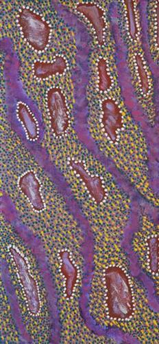
Tuwa in Puntawarri

“I do tuwa (sandhill) in my own style because that’s our Country. That’s a sandhill, that’s the Dreaming- the Jukurrpa. That’s our culture.

They stay there and we go through the sandhills at Puntawarri in the car. We go first tuwa, then the second tuwa, looking for the waterholes. Go up, up, up- ‘nother tuwa, ‘nother tuwa.

Long time [ago] in Puntawarri, when I was a little girl [with] my Nana and Pop [Dadda Samson and Yanjimi Peter Rowlands] we went climbing up the sandhill. And when I went up my Nana and Pop were at the bottom under a tree and I came down running then rolling, rolling right down to the ground! But I was ok- he right!”

– Judith Anya Samson

Puntawarri is an important cultural area located on the middle stretches of the Canning Stock Route and east of the Jigalong Mission (now Jigalong Aboriginal community), where Anya grew up with her grandmother and renowned Martumili Artist, Dadda Samson (dec.). Puntawarri is also the site of an abandoned community, a waterhole, creek and lake. Puntawarri’s close proximity to Jigalong Mission made it a popular site for Martu to visit during the ‘mission days’. While growing up at Jigalong Mission in the 1960’s, Dadda would return to Puntawarri every weekend to hunt and camp. 

For many Martu, like Anya’s family, Jigalong Mission was the site where their pujiman (traditional, desert dwelling) lifestyle came to an end from the late 1940s as they transitioned to a life as stockmen and women working in cattle stations in the Pilbara region and beyond. In the wake of the extreme and prolonged drought of the 1960s, the last of the remaining pujimanpa (desert dwellers) were forced to move to missions like Jigalong, where a supply of food and water was assured. There, many Martu were reunited with family members that had already moved in from the desert.

The traditional lands of the Martu people encompass the Great Sandy Desert and Rudall River regions of Western Australia, an enormous tract dominated by distinctive red tali, or tuwa (sandhills). These sandhills present an unforgiving landscape; sparse vegetation covers a seemingly never ending expanse of dunes, and yet these lands and the location of resources within them was known intimately by its pujiman inhabitants.


111582171357


Kaalpa (Kalypa, Canning Stock Route Well 23)

Kaalpa (Kalypa, Canning Stock Route Well 23) is a permanent water source located northeast of Kumpupirntily (Kumpupintily, Lake Disappointment). This site is a place of great cultural significance, and is also known for good hunting. Adjacent to the waterhole is a hill of the same name. The landscape around Kaalpa is parlkarra (flat country), bordered by tali (sandhills) stretching as far as Windy Corner, toward the border of Western Australia and the Northern Territory. The large and dangerous Jukurrpa (Dreamtime) mosquito and fly beings partially created the landforms in this area and continue to live underground here.

At Kaalpa the Minyipuru (Jakulyukulyu, Seven Sisters) met a group of men; it was the first time either group had seen members of the opposite sex. The men were sitting down at Kaalpa doing law business when the Minyipuru arrived. They tried to grab the women, but the Minyipuru chased them, hitting them with their digging sticks and whipping them, then leaving them lying there. From Kaalpa the Minyipuru continued dancing as they travelled to Kartarru (Canning Stock Route Well 24).

Minyipuru is a central Jukurrpa narrative for Martu, Ngaanyatjarra, Pitjantjatjara and Yankunytjatjara people that is associated with the seasonal Pleiades star constellation. Relayed in song, dance, stories and paintings, Minyipuru serves as a creation narrative, a source of information relating to the physical properties of the land, and an embodiment of Aboriginal cultural laws. Beginning in Roebourne on the west coast of Western Australia, the story morphs in its movement eastward across the land, following a group of women as they walk, dance, and even fly from waterhole to waterhole. As they travel the women camp, sing, wash, dance and gather food, leaving markers in the landscape and creating landforms that remain to this day, such as groupings of rocks and trees, grinding stones and seeds. During the entirety of their journey the women are pursued by a lustful old man, Yurla, although interactions with other animals, groups of men, and spirit beings are also chronicled in the narrative.

The intersection of the Canning Stock Route with Kaalpa also made this a site of early contact with Europeans for many Martu then living a pujiman (traditional, desert dwelling) life in the desert. Following the route’s construction, Martu encountered Europeans and other Martu working as cattle drovers as they would travel up and down the Stock Route from water source to water source. Increasingly, pujimanpa (desert dwellers) followed the route to newly established ration depots, mission and pastoral stations. They were drawn to the route in search of food, by a sense of curiosity, or by loneliness. By the late 1950s and early 1960s, most of the desert family groups had left the desert. Eventually, these factors combined with an extreme and prolonged drought in the 1960s to prompt the few remaining pujimanpa to move in from the desert.

111582171354


Untitled

This is Mayiwalku’s Country- her ‘ngurra’ (home Country, camp). People identify with their ngurra in terms of specific rights and responsibilities, and the possession of intimate knowledge of the physical and cultural properties of one’s Country. Painting ngurra, and in so doing sharing the Jukurrpa (Dreaming) stories and physical characteristics of that place, has today become an important means of cultural maintenance. 

Mayiwalku’s ngurra encompasses the Country that she and her family walked in the pujiman (traditional, desert-dwelling) era. Mayiwalku was born at Yirnangarri. She grew up, walked and hunted primarily around the Country extending across the Punmu, Kunawarritji (Canning Stock Route Well 33) and Karlamilyi (Rudall River) regions. Following the death of both their parents, Mayiwalku and her sisters travelled alone between Punmu and Kunawarritji, occasionally meeting with other family groups. They continued to live nomadically before eventually deciding to move to Jigalong Mission along with many other relatives following an extreme and prolonged drought in the 1960s. 

Portrayed in this work are features of Mayiwalku’s ngurra, such as the dominant permanent red tali (sandhills), warta (trees, vegetation), and the individually named water sources she and her family camped at. These include Januwa, Jilankujarra, Karlajarntu, Kartungu, Kularti, Kumpupajanu, Kunalimpi, Kunarra, Marnakarti, Pangkapirni, Wilunganinya, Wurur-wururna, Yilyara, and Yirrajarra Rock holes, waterholes, soaks and springs were all extremely important sites for Martu people during the pujiman period, and are generally depicted with circular forms. 

The encyclopaedic knowledge of the location, quality and seasonal availability of the hundreds of water bodies found in one’s Country sustained Martu as they travelled across their Country, hunting and gathering, visiting family, and fulfilling ceremonial obligations. They would traverse very large distances annually, visiting specific areas in the dry and wet season depending on the availability of water and the corresponding cycles of plant and animal life on which hunting and gathering bush tucker was reliant. As they travelled and hunted they would also burn areas of Country, generating a greater diversity of plant and animal life.