111982287317


Ngalkodjek Yawkyawk

This artwork depicts the Ngalkodjek Yawkyawk of Barrihdjowkkeng country.

“This story is very old. That old man [my father Crusoe Kuningbal] when he was alive, told that story to me, to all of us. He told us about the yawkyawk (mermaid) spirit women called Ngalkodjek who lives in the billabong on my country. He told us how they call out loudly, how they call out as they walk along.

That is what they do, calling out. They walked around eating bush foods like those little bush yams. They would pound the yams into a pulp and eat them. That is their traditional food which they eat.

When they walk down from the bush, they follow a set path that belongs to them and they walk along calling out. That is their path which they take. It is an old traditional route.

They placed a woman’s breast into the country. That rock was not there originally, but it was a woman’s breast. It is the breast of those women.

They put that djang [sacred place] there, and then at the time when non-Aboriginal people arrived in the region, then the breast turned to stone. Now it has turned solid into rock.”

– Owen Yalandja

111576666595


Untitled

This painting is a collaborative work between Dadda Samson and her granddaughter Judith Anya Samson. It is an area of their country east of the Community of Jigalong, where the artists are from. While growing up at Jigalong mission Dadda returned to her ngurra (home Country, camp) most weekends to hunt and camp. Dadda is recognised as a great authority in Jigalong and has been teaching Judith to paint for a number of years, sharing her knowledge of Country and jukurrpa (dreaming) for those areas. 

111576666594


Untitled

This painting is a collaborative work between Dadda Samson and her granddaughter Judith Anya Samson. It is an area of their country east of the Community of Jigalong, where the artists are from. While growing up at Jigalong mission Dadda returned to her home frequently to hunt and camp. Dada is recognised as a great authority in Jigalong and is particularly knowledgeable about Country in that area. Dadda has been teaching Judith to paint for a number of years, sharing with her knowledge of Country and jukurrpa (dreaming) for those areas.

111581715933


Puntawarri

This painting depicts Puntawarri, the artists’ mother’s family’s country. Puntawarri is on the middle stretches of the Canning Stock Route, near Well 17 also known as Durba Springs. Puntawarri is an important cultural area, east of the Jigalong Aboriginal Community, where the artist now lives with her grandmother. The artist’s grandmother frequently travelled and hunted with her family in this area when she was a young girl, and is now teaching Judith the stories for this country.

111582286919


Untitled

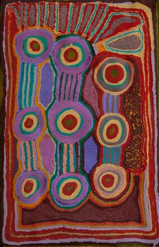
“When Martu paint, it’s like a map. Martu draw story on the ground and on the canvas, and all the circle and line there are the hunting areas and different waters and tracks where people used to walk, and [some you] can’t cross, like boundaries. So nowadays you see a colourful painting and wonder what it is, but that’s how Martu tell story long ago. It’s not just a lovely painting, it’s a story and a songline and a history and everything that goes with it.” 

– Ngalangka Nola Taylor and Joshua Booth

This work portrays an area of Country that can be interpreted in multiple ways. Firstly, the image may be read as an aerial representation of a particular location known to the artist- either land that they or their family travelled, from the pujiman (traditional, desert dwelling) era to now. During the pujiman period, Martu would traverse very large distances annually in small family groups, moving seasonally from water source to water source, and hunting and gathering bush tucker as they went. At this time, one’s survival depended on their intimate knowledge of the location of resources; thus physical elements of Country, such as sources of kapi (water), tali (sandhills), different varieties of warta (trees, vegetation), ngarrini (camps), and jina (tracks) are typically recorded with the use of a use of a system of iconographic forms universally shared across the desert. 

An additional layer of meaning in the work relates to more intangible concepts; life cycles based around kalyu (rain, water) and waru (fire) are also often evident. A thousands of year old practice, fire burning continues to be carried out as both an aid for hunting and a means of land management today. As the Martu travelled and hunted they would burn tracts of land, ensuring plant and animal biodiversity and reducing the risk of unmanageable, spontaneous bush fires. The patchwork nature of regrowth is evident in many landscape works, with each of the five distinctive phases of fire burning visually described with respect to the cycle of burning and regrowth.  

Finally, metaphysical information relating to a location may also be recorded; Jukurrpa (Dreaming) narratives chronicle the creation of physical landmarks, and can be referenced through depictions of ceremonial sites, songlines, and markers left in the land. Very often, however, information relating to Jukurrpa is censored by omission, or alternatively painted over with dotted patterns.

111582286888


Mungili Waterholes and Rock Holes

“I was swimming there. Yeah, we go visit them a long time [ago]. We drink it, rain water from the rain. Big waterhole. It’s a fresh water, when the rain comes, fills it up. One for swimming and another rock hole for drinking.”

– Marlene Anderson

In this work Marlene depicts a waterhole and rock hole located in Mungili, the small outstation community located just off the Eagle Highway in Western Australia, approximately 430 kilometres northeast of Wiluna and 250 kilometres north of Warburton. Marlene grew up in Mungili, and as such it forms a significant part of her ‘ngurra’ (home Country, camp). Typically Marlene depicts this site with a central large circular form that represents the main waterhole, surrounded by smaller circular forms representing satellite water bodies.

During the pujiman (traditional, desert dwelling) period, knowledge of water sources was critical for survival, and today Martu Country is still defined in terms of the location and type of water. Each of the hundreds of claypans, rockholes, waterholes, soaks and springs found in the Martu desert homelands is known through real life experience and the recounting of Jukurrpa (Dreaming) narratives by name, location, quality and seasonal availability. This encyclopedic knowledge extends even to the nature and movement of arterial waterways, and sustained Martu as they travelled across their Country, hunting and gathering, visiting family, and fulfilling ceremonial obligations. They would traverse very large distances annually, visiting specific areas in the dry and wet season depending on the availability of water and the corresponding cycles of plant and animal life on which hunting and gathering bush tucker was reliant.

111582286864


Kun Kun (Kuny-Kuny)

“My ngurra (home Country, camp) long, long time ago, Kun Kun! This is a big waterhole. In Kun Kun, my Country, all the animals are coming to drink here. Big and small kangaroos, snakes, goannas, emus, skinks – they all drinking here. Big tali (sandhills). Big ones, four of them near the waterhole.”

– Kumpaya Girgirba (Girgaba)

Kun Kun (Kuny-kuny) is a soak accessing a large body of underground water, located south east of Kunawarritji (Canning Stock Route Well 33). The site is sacred for its association with the marlu (kangaroo) Jukurrpa (Dreaming), and was an important ceremonial site during the pujiman (traditional, desert dwelling) period.

Kun Kun lies within Kumpaya’s ngurra (home Country, camp), the area which she knew intimately and travelled extensively with her family in her youth. The Western Desert term ‘ngurra’ is hugely versatile in application. Broadly denoting birthplace and belonging, ngurra can refer to a body of water, a camp site, a large area of Country, or even a modern house. People identify with their ngurra in terms of specific rights and responsibilities, and the possession of intimate knowledge of the physical and cultural properties of one’s Country. This knowledge is traditionally passed intergenerationally through family connections. Painting ngurra, and in so doing sharing the Jukurrpa stories and physical characteristics of that place, has today become an important means of cultural maintenance. Physical maintenance of one’s ngurra, like cultural maintenance, ensures a site’s wellbeing, and is a responsibility of the people belonging to that area. 

During the pujiman period, knowledge of water sources was critical for survival, and today Martu Country is still defined in terms of the location and type of water. Each of the hundreds of claypans, rockholes, waterholes, soaks and springs found in the Martu desert homelands is known by name, location, quality and seasonal availability through real life experience and the recounting of Jukurrpa narratives. 

111582286806


Kinyu (Canning Stock Route Well 35)

Kinyu (Canning Stock Route Well 35) is a small yinta (permanent spring) that was a popular camping site during the pujiman (traditional, desert dwelling) era. Kinyu forms part of Kumpaya’s ngurra (home Country, camp), the area which she knew intimately and travelled extensively with her family in her youth.

As alluded to in Kumpaya’s account, the site is home to the ancestral mother dingo, a generous provider and fierce protector of her Martu countrymen. Kinyu is so revered that the site and its associated ancestral being are often deferentially called jarntu (dog) in place of uttering the actual name. The site is believed to possess healing and magical powers, and children born here are said to inherit these same powers. 

During the Jukurrpa (Dreaming), Kinyu was the home for a family of dingoes; a mother, father, and their litter of pups. Originally the family had travelled to Wirlarra, following the call of the moon. At Wirlarra the moon cared for them and created a windbreak for the family to shelter. The dingoes stayed for a time at Wirlarra, scratching into the earth to create several distinctive small salt water pools which are still visited by the Martu for their healing properties. After a time, the dingoes continued travelling eastward toward the rising moon until they reached Kinyu, where they remained until all of the dingo pups had grown up. From Kinyu the family travelled further east. 

The intersection of the Canning Stock Route with Kinyu also made this a site of early contact with Europeans for many Martu then living a pujiman life in the desert. Following the route’s construction, Martu encountered Europeans and other Martu working as cattle drovers as they would travel up and down the Stock Route from water source to water source. Increasingly, pujimanpa (desert dwellers) followed the route to newly established ration depots, mission and pastoral stations. They were drawn to the route in search of food, by a sense of curiosity, or by loneliness. By the late 1950s and early 1960s, most of the desert family groups had left the desert. Eventually, these factors combined with an extreme and prolonged drought in the 1960s to prompt the few remaining pujimanpa to move in from the desert.