111582430421


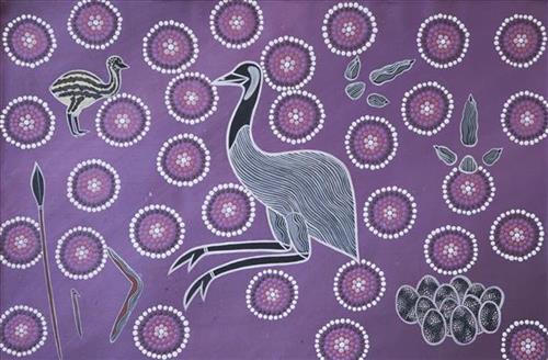
Karlaya (Emu)

Depicted in this work are karlaya (emus); large, flightless birds endemic to Australia, and found across the whole country. Emus have been hunted by Martu people as a source of bush tucker from the pujiman (traditional, desert dwelling) era through to today. Typically, emus were tracked using their distinctive jina (tracks, footprints). Acute skill in track observation and identification traditionally possessed by Aboriginal people developed directly in relation to their past hunter-gatherer existence, when survival depended in large part on the successful tracking of hunted animals. In the absence of an actual animal sighting, tracks act as an identifier that an animal was present, which were then followed to the animal’s location.

Once caught, the emu and its eggs were consumed, fat was harvested for several medicinal applications, bones were shaped into tools, feathers were used for adornment, and tendons substituted for string. 

During the pujiman period, Martu would traverse very large distances annually in small family groups, moving seasonally from water source to water source, and hunting and gathering bush tucker as they went. Whilst desert life has moved away from mobile hunter-gatherer subsistence throughout the course of the twentieth century, bush tucker continues to be a significant component of the modern Martu diet. Hunting and gathering bush tucker remains equally valuable as an important cultural practice that is passed on intergenerationally. Though hunting and gathering implements have been modernised, methods of harvesting, tracking and the use of fire burning to drive animals from their retreats are still commonly practiced today.

111582430420


Tuwa Emu Track, Lake Disappointment

“Emu go to the springs to have a drink of water and then move on to the next one.”

– Judith Anya Samson

Kumpupirntily lies within Anya’s ngurra (home Country, camp) through her family. This a stark, flat and unforgiving expanse of blinding salt lake is surrounded by sand hills, and located in the Little Sandy and Gibson Desert of Western Australia. Kumpupirntily translates to ‘bladder burst’; the lake was formed when the bladder of the Jila Kujarra (Two Snakes) burst here. Jila Kujarra is one of the key Jukurrpa (Dreaming) narratives for the Martu. Though the story belongs to Warnman people, it is shared across the Western Desert with several other language groups. The narrative centres on the travels of two snakes as they are pursued by the Niminjarra, spiritual ancestors of the Warnman people.  Later in the Jukurrpa period the Ngayurnangalku (ancestral cannibal beings) made Kumpupirntily their home, where they continue to remain today. For this reason Kumpupirntily is considered one of the most sacred and dangerous sites of the Western Desert. The Ngayurnangalku are fearsome ancestral cannibal beings said to resemble people in their appearance, except for their fangs and long curved knife like fingernails they use to catch and hold their human victims.  At Kumpupirntily, the Ngayurnangalku had a meeting to debate whether or not they would continue to live as cannibals, and eventually came to the decision to stop eating people. That night, a female baby cannibal was born. Following protocol, the baby also had to be consulted by the group. She determined that the Ngayurnangalku should continue to eat people. Her decision divided the group, and from this point the group from the east continued to live as ‘bad’ cannibals at Kumpupirntily, while the group from the west became ‘good’, thereafter consuming only animals.  The cannibal Ngayurnangalku still live beneath the crust of Kumpupirntily lake in an underground world lit by their own sun. They surface only to feed on human flesh, coming in and out of the world we see through a small hill that acts as a gateway between worlds; Yapu Maparnpa (magical hill). Stored with the Ngayurnangalku in their underground world is an arsenal of maparnpa (holding power for sorcery) weapons, as well as deposits of pujurrpa (red ochre) that the Ngayurnangalku use to paint themselves with when they dance. Several phenomena at Kumpupirntily act as a warning of the imminent appearance of the Ngayurnangalku; still skies, wilany (boomerang-shaped clouds), and the emergence of the parla-parla (type of lizard), smacking their mouths. The vigilance of the Martu as they travel in the Country around Kumpupirntily is so great that several other precautions are followed; fires are not lit, planes and helicopters are not flown directly over the area, and digging in the lake is strongly discouraged. All of these activities are believed to disturb the Ngayurnangalku, causing them to rise from their underground world. Karlaya (emu) were traditionally hunted during the pujiman (traditional, desert dwelling) era, and they continue to be a favoured bush tucker for Martu today. During the pujiman period, Martu would traverse very large distances annually in small family groups, moving seasonally from water source to water source, and hunting and gathering bush tucker as they went. Jina (tracks, footprints) are used by Martu people when tracking bush tucker. In the absence of an actual animal sighting, tracks act as an identifier that an animal was present, which can then be followed to the animal’s present location. Besides providing information on location, Martu are able to interpret from tracks the passage of time since the tracks were imprinted, as well as the corresponding animal species and its size. The softer and more extensive the ground surface, the easier it is to locate and follow tracks, thus certain conditions are favoured for tracking. Tuulparra (spring) and yalijarra (hot time) are preferred over wantajarra (winter), when south easterly tradewinds blow strongly to obscure tracks. Tracks and burrows are also more readily visible in early growth lands, such as nyurnma (freshly burnt Country) and waru-waru (growth of new shoots and young plants). For this reason, fire burning is an important tool in animal tracking. Small burns are lit to clear vegetation, expose burrows, and to allow for access to walk and track readily in exposed sands, while simultaneously providing diverse regenerating habitats.

111582430414


Wild Desert Flowers

“I love going out bush camping. I’ve been going out to my mothers and fathers country and looking around at all that. The flowers are always blooming up in September. When you’re travelling on Ranger trips from Wiluna over the sand dunes you can see them all looking lovely.”

– Desrea Anderson

This work depicts the remarkably diverse flora found through Martu Country. These plants are not only vital as significant food sources, but also celebrated for their aesthetic splendour. In the context of the often harsh and arid environments in which desert flowers bloom, their vibrancy, delicacy, and variation become even more spectacular. 

111582430412


Untitled

This is Bugai’s Country- her ‘ngurra’ (home Country, camp). People identify with their ngurra in terms of specific rights and responsibilities, and the possession of intimate knowledge of the physical and cultural properties of one’s Country. Painting ngurra, and in so doing sharing the Jukurrpa (Dreaming) stories and physical characteristics of that place, has today become an important means of cultural maintenance. 

Bugai’s ngurra encompasses the Country that she and her family walked in the pujiman (traditional, desert-dwelling) era. At this time Bugai travelled nomadically with her own and other family groups, most notably the Bidu family. The Country they traversed encompassed an enormous tract of land, with an aerial distance of more than 600 kilometres, from present day Balfour Downs Station to Kunawarritji (Canning Stock Route Well 33). Bugai was born at Pulkinya. She grew up, walked and hunted primarily around Parnngurr, Punmu, Kun Kun (Kuny-kuny) and Kunawarritji. As a young woman Bugai travelled with her husband through the Karlamilyi (Rudall River) region and up and down the Canning Stock Route, where she first met cattle drovers. She continued to live nomadically before eventually deciding to move to Jigalong Mission along with many other relatives following an extreme and prolonged drought in the 1960s. 

Portrayed in this work are features of Bugai’s ngurra, such as the striking salt lakes, dominant permanent red tali (sandhills), warta (trees, vegetation), and the individually named water sources Bugai and her family camped at. These include Parnngurr, Martilirri, Wangkakalu, Kurta-kurta (Camel Rock), Pimurlu, Jilkupuka (Canning Stock Route Well 21), Kaalpa (Canning Stock Route Well 23), Kartarru (Canning Stock Route Well 24), Wantili (Warntili, Canning Stock Route Well 25), Tiwa (Canning Stock Route Well 26), Partujarrapirri, Raarki (Canning Stock Route Well 27), Wuranu (Canning Stock Route Well 29), Juntu- juntu (Canning Stock Route Well 30), and Kunawarritji. Rock holes, waterholes, soaks and springs were all extremely important sites for Martu people during the pujiman period, and are generally depicted with circular forms. 

The encyclopaedic knowledge of the location, quality and seasonal availability of the hundreds of water bodies found in one’s Country sustained Martu as they travelled across their Country, hunting and gathering, visiting family, and fulfilling ceremonial obligations. They would traverse very large distances annually, visiting specific areas in the dry and wet season depending on the availability of water and the corresponding cycles of plant and animal life on which hunting and gathering bush tucker was reliant. As they travelled and hunted they would also burn areas of Country, generating a greater diversity of plant and animal life.

111582430410


Wantili (Warntili, Canning Stock Route Well 25)

“Bugai always tells about Wantili (Warntili, Canning Stock Route Well 25) because she grew up around Wantili. Her family would travel between Wantili, Kaalpa, Juntu-juntu, Raarki, and Wuranu Wells along the Canning Stock Route. She paints around Wantili. She saw whitefellas there for the first time, Canning mob when they were travelling up and down the stock route with the bullock. She was a young girl walking around at Wantili. Big mob of people they been walking around there. Canning and his drovers were travelling, making the road. They were running away from those whitefellas, watching them from a long distance. She was a teenager when she was travelling around there with her four mothers and one daddy. They used to travel around in family groups, Bugai and Jakayu [Biljabu], and Jakayu’s nyupa (partner) Phillip Biljabu.” 

– Bugai Whyoulter, as translated by her grandson, Cyril Whyoulter


“I was just becoming a teenager, still travelling around with my mother and father. We were at Juntu-juntu, Wuranu, Raarki, Tiwa and Wantili. At Wantili we killed a cow, they were bringing cattle through from Kunawarritji … Wantili was a good place to make yakapiri (woven bark sandals).”

– Bugai Whyoulter as translated by Ngalangka Nola Taylor


Wantili, which forms the focus of much of Bugai’s work, is a large round jurnu (soak) and linyji (claypan) near Well 25 on the Canning Stock Route. The Wantili region is dominated by claypans surrounded by tuwa (sandhills), and Nyilangkurr, a prominent yapu (hill) is located close to the eastern edge of the claypan. Following rain the typically dry claypans are filled with water, with the overflow from nearby waterholes flowing to Wantili. At that time, Wantili becomes an important place for obtaining fresh water for drinking and bathing. Wantili is significant for the fact that at this site Kartujarra, Manyjilyjarra, Putijarra and Warnman people would all come together for ceremonies during the pujiman (traditional, desert dwelling) era. Many jiwa (stones used by women for grinding seeds) from these times can still be found there today.

Wantili lies within Bugai’s ngurra (home Country, camp). As described in her account, Wantili was one of the sites she knew intimately and travelled extensively with her family and other family groups during the pujiman period. At this time, Martu would traverse very large distances annually, moving seasonally from water source to water source, and hunting and gathering bush tucker as they went. Knowledge of water sources was critical for survival, and today Martu Country is still defined in terms of the location and type of water. Each of the hundreds of claypans, rockholes, waterholes, soaks and springs found in the Martu desert homelands is known by name, location, quality and seasonal availability through real life experience and the recounting of Jukurrpa (Dreaming) narratives. 

Wantili is also especially significant to Bugai as it was here that she saw whitefellas for the first time; drovers with their cattle travelling along the Canning Stock Route. The establishment of the route by Alfred Canning and his team in 1910 resulted in first contact with Europeans for many Martu, including Bugai and her family, then living a pujiman life in the desert. Encounters occurred between Martu, Europeans, and other Martu working as cattle drovers as they travelled and down the Stock Route from water source to water source. Increasingly, Martu followed the route to newly established ration depots, mission and pastoral stations. They were drawn to the route in search of food, by a sense of curiosity, or by loneliness. By the late 1950s and early 1960s, most of the desert family groups had left the desert. Eventually, these factors combined with an extreme and prolonged drought in the 1960s to prompt the few remaining pujiman to move in from the desert. Bugai returned to the Wantili area as a young woman, when she herself drove cattle along the Stock Route.

Culturally, Wantili is an incredibly important site, ‘where the creation started.’ (Cyril Whyoulter). In this creation story, the world was initially dark, and people were like rocks, with no arms or legs. Following the sun’s first rising, life-forms become increasingly complex while particular features in the land are created. Beyond these details much of the Jukurrpa narrative relating to Wantili is ngurlu (sacred, taboo), and only for Martu, but the site is open, and anyone can go there. 

Wantili is also one of the many sites featured in the epic Minyipuru (Jakulyukulyu, Seven Sisters) Jukurrpa story. Minyipuru is a central Jukurrpa narrative for Martu, Ngaanyatjarra, Pitjantjatjara and Yankunytjatjara people that is associated with the seasonal Pleiades star constellation. Relayed in song, dance, stories and paintings, Minyipuru serves as a creation narrative, a source of information relating to the physical properties of the land, and an embodiment of Aboriginal cultural laws. The story follows the movement of a group of women travelling all the way across the desert, beginning at Roebourne on the coast of Western Australia, as they are pursued by Yurla, a lustful old man. As the women travelled, they stopped to rest at many sites to eat, dance, rest and sing, on the way leaving behind an assortment of articles that became formations in the land, such as groupings of rocks and trees, grinding stones and seeds. The sisters rested at Wantili before throwing seeds, then continued their journey far to the east and beyond Martu Country, stopping at various sites through central and South Australia.

111582430409


Water Flow

“When I paint with these colours and in this style, it reminds me of when I was back in Bidgydanga, watching the water and currents flow.”

– Ciarn Dean-Bullen


“When Martu paint, it’s like a map. Martu draw story on the ground and on the canvas, and all the circle and line there are the hunting areas and different waters and tracks where people used to walk, and [some you] can’t cross, like boundaries. So nowadays you see a colourful painting and wonder what it is, but that’s how Martu tell story long ago. It’s not just a lovely painting, it’s a story and a songline and a history and everything that goes with it.” 

– Ngalangka Nola Taylor and Joshua Booth

This work portrays an area of Country that can be interpreted in multiple ways. Firstly, the image may be read as an aerial representation of a particular location known to the artist- either land that they or their family travelled, from the pujiman (traditional, desert dwelling) era to now. During the pujiman period, Martu would traverse very large distances annually in small family groups, moving seasonally from water source to water source, and hunting and gathering bush tucker as they went. At this time, one’s survival depended on their intimate knowledge of the location of resources; thus physical elements of Country, such as sources of kapi (water), tali (sandhills), different varieties of warta (trees, vegetation), ngarrini (camps), and jina (tracks) are typically recorded with the use of a use of a system of iconographic forms universally shared across the desert. 

An additional layer of meaning in the work relates to more intangible concepts; life cycles based around kalyu (rain, water) and waru (fire) are also often evident. A thousands of year old practice, fire burning continues to be carried out as both an aid for hunting and a means of land management today. As the Martu travelled and hunted they would burn tracts of land, ensuring plant and animal biodiversity and reducing the risk of unmanageable, spontaneous bush fires. The patchwork nature of regrowth is evident in many landscape works, with each of the five distinctive phases of fire burning visually described with respect to the cycle of burning and regrowth.  

Finally, metaphysical information relating to a location may also be recorded; Jukurrpa (Dreaming) narratives chronicle the creation of physical landmarks, and can be referenced through depictions of ceremonial sites, songlines, and markers left in the land. Very often, however, information relating to Jukurrpa is censored by omission, or alternatively painted over with dotted patterns.

111582430408


Water Flow

“When I paint with these colours and in this style, it reminds me of when I was back in Bidgydanga, watching the water and currents flow.”

– Ciarn Dean-Bullen


“When Martu paint, it’s like a map. Martu draw story on the ground and on the canvas, and all the circle and line there are the hunting areas and different waters and tracks where people used to walk, and [some you] can’t cross, like boundaries. So nowadays you see a colourful painting and wonder what it is, but that’s how Martu tell story long ago. It’s not just a lovely painting, it’s a story and a songline and a history and everything that goes with it.” 

– Ngalangka Nola Taylor and Joshua Booth

This work portrays an area of Country that can be interpreted in multiple ways. Firstly, the image may be read as an aerial representation of a particular location known to the artist- either land that they or their family travelled, from the pujiman (traditional, desert dwelling) era to now. During the pujiman period, Martu would traverse very large distances annually in small family groups, moving seasonally from water source to water source, and hunting and gathering bush tucker as they went. At this time, one’s survival depended on their intimate knowledge of the location of resources; thus physical elements of Country, such as sources of kapi (water), tali (sandhills), different varieties of warta (trees, vegetation), ngarrini (camps), and jina (tracks) are typically recorded with the use of a use of a system of iconographic forms universally shared across the desert. 

An additional layer of meaning in the work relates to more intangible concepts; life cycles based around kalyu (rain, water) and waru (fire) are also often evident. A thousands of year old practice, fire burning continues to be carried out as both an aid for hunting and a means of land management today. As the Martu travelled and hunted they would burn tracts of land, ensuring plant and animal biodiversity and reducing the risk of unmanageable, spontaneous bush fires. The patchwork nature of regrowth is evident in many landscape works, with each of the five distinctive phases of fire burning visually described with respect to the cycle of burning and regrowth.  

Finally, metaphysical information relating to a location may also be recorded; Jukurrpa (Dreaming) narratives chronicle the creation of physical landmarks, and can be referenced through depictions of ceremonial sites, songlines, and markers left in the land. Very often, however, information relating to Jukurrpa is censored by omission, or alternatively painted over with dotted patterns.

111582430407


Untitled

“When Martu paint, it’s like a map. Martu draw story on the ground and on the canvas, and all the circle and line there are the hunting areas and different waters and tracks where people used to walk, and [some you] can’t cross, like boundaries. So nowadays you see a colourful painting and wonder what it is, but that’s how Martu tell story long ago. It’s not just a lovely painting, it’s a story and a songline and a history and everything that goes with it.” 

– Ngalangka Nola Taylor and Joshua Booth

This work portrays an area of Country that can be interpreted in multiple ways. Firstly, the image may be read as an aerial representation of a particular location known to the artist- either land that they or their family travelled, from the pujiman (traditional, desert dwelling) era to now. During the pujiman period, Martu would traverse very large distances annually in small family groups, moving seasonally from water source to water source, and hunting and gathering bush tucker as they went. At this time, one’s survival depended on their intimate knowledge of the location of resources; thus physical elements of Country, such as sources of kapi (water), tali (sandhills), different varieties of warta (trees, vegetation), ngarrini (camps), and jina (tracks) are typically recorded with the use of a use of a system of iconographic forms universally shared across the desert. 

An additional layer of meaning in the work relates to more intangible concepts; life cycles based around kalyu (rain, water) and waru (fire) are also often evident. A thousands of year old practice, fire burning continues to be carried out as both an aid for hunting and a means of land management today. As the Martu travelled and hunted they would burn tracts of land, ensuring plant and animal biodiversity and reducing the risk of unmanageable, spontaneous bush fires. The patchwork nature of regrowth is evident in many landscape works, with each of the five distinctive phases of fire burning visually described with respect to the cycle of burning and regrowth.  

Finally, metaphysical information relating to a location may also be recorded; Jukurrpa (Dreaming) narratives chronicle the creation of physical landmarks, and can be referenced through depictions of ceremonial sites, songlines, and markers left in the land. Very often, however, information relating to Jukurrpa is censored by omission, or alternatively painted over with dotted patterns.

111582430396


Puntawarri

“All around is sandhills and lakes on every side. You can see the grass, but the lakes are all dry. In the middle is Puntawarri waterhole. That’s the jila (snake) place, two jila. They nyupa (spouses), they darlings, man and woman. They sleeping near to Puntawarri. It’s a hole in the ground- that jila will come out of the ground and all the dust will go everywhere. All the dust going everywhere, the dust that flies up when the jila flies up out of its hole. The jila isn’t in that place anymore. It’s gone now but that jila used to stop there.” 

 – Helen Dale Samson

Puntawarri is an important cultural area located on the middle stretches of the Canning Stock Route and east of the Jigalong Mission (now Jigalong Aboriginal community). It is also the site of an abandoned community, a waterhole, creek and lake. Puntawarri’s close proximity to Jigalong Mission made it a popular site for Martu to visit during the ‘mission days’. Dale was born at Jigalong Mission, and continues to live in the community now located there today. Though she grew up in the dormitory at Jigalong, she spent her weekends and holidays in the bush, camping at sites such as Puntawarri with her extended family. Once married, she lived around Puntawarri, walking and hunting in the surrounding Country.

For many Martu, like Dale’s family, Jigalong Mission was the site where their pujiman (traditional, desert dwelling) lifestyle came to an end from the late 1940s as they transitioned to a life as stockmen and women working in cattle stations in the Pilbara region and beyond. In the wake of the extreme and prolonged drought of the 1960s, the last of the remaining pujimanpa (desert dwellers) were forced to move to missions like Jigalong, where a supply of food and water was assured. There, many Martu were reunited with family members that had already moved in from the desert.

The waterhole at Puntawarri is said to be populated by several kinds of ancestral jila, as referred to by Dale in her account. However the site is best known for its association with the Ngayurnangalku, fearsome ancestral cannibal beings. During the Jukurrpa (Dreaming) the Ngayurnangalku came together from all over the desert, first stopping near Puntawarri on their travels to Kumpupirntily (Kumpupintily, Lake Disappointment). At Kumpupirntily, they had a big meeting to debate whether or not they would continue to live as cannibals, and eventually came to the decision to stop eating people. That night, a female baby cannibal was born to the eastern Ngayurnangalku on the red sandhills at Puntawarri, where she continues to live today as the ‘big mummy’ Ngayurnangalku. Following protocol, the baby also had to be consulted by the group. She determined that the Ngayurnangalku should continue to eat people. Her decision divided the group, and from this point the group from the east continued to live as ‘bad’ cannibals at Kumpupirntily, while the group from the west became ‘good’, thereafter consuming only animals.

111582430394


Kaalpa (Kalypa, Canning Stock Route Well 23)

“Kaalpa (Kalypa, Canning Stock Route Well 23) is my grandfather’s Country. There’s a waterhole there, Kaalpa waterhole. It’s my two pops’ Country. They been walking around, hunting around Kaalpa. You can see a yapu (rock), warla (lake), claypans, karru (creek) and tuwa (sandhills) there. It’s on the [Canning] Stock Route, it’s Well 23. One walypala One walypala (whitefella) well, and a real kalyu (water) there, jurnu. The Seven Sisters landed there, Jukurrpa (Dreaming). That man Yurla yapu (hill, stone, rock) there.” [Yurla, who chased the Seven Sisters during the Jukurrpa remains at Kaalpa in the form of a rock]) 

In pujiman (traditional, desert dwelling) days, pujimanpa (desert born people) walking around all this Country. My pops told me about that place, a big flat area, parlkarra (flat country) good for hunting parnajarrpa (goanna), lunki (witchetty grub), lungkurta (blue tongue lizard), wamurla (bush tomato), jinyjiwirrilyi (wild gooseberry). Kaalpa is a busy place for emus getting a drink. 

The old people were telling me “Kaalpa’s your grandfather’s Country, you gotta paint it.” I went [to Kaalpa] for the first time [in 2018] on a Martumili KJ [Kanyirninpa Jukurrpa] trip. We went out there when we were looking for the [Greater] Bilby. They took me and [my sister] Tamisha, they showed us our grandfather’s Country, Well 23. I went out there, had a good look, walked around, and went back to Wantili (Warntili, Canning Stock Route Well 25), Parnngurr, and I started painting it. Now it’s my mind, now I know what Kaalpa looks like. When I went there, I was pukurlpa (happy). It made you open up your spirit, it feels like home.”

 – Corban Clause Williams

Kaalpa is a permanent water source located northeast of Kumpupirntily (Kumpupintily, Lake Disappointment). This site is a place of great cultural significance, and is also known for good hunting. Adjacent to the waterhole is a hill of the same name. The landscape around Kaalpa is parlkarra (flat country), bordered by tali (sandhills) stretching as far as Windy Corner, northeast and towards the border of Western Australia and the Northern Territory. The large and dangerous Jukurrpa (Dreamtime) mosquito and fly beings partially created the landforms in this area and continue to live underground here.

Kaalpa also features in the Minyipuru (Jakulyukulyu, Seven Sisters) Jukurrpa, a central creation narrative for Martu, Ngaanyatjarra, Pitjantjatjara and Yankunytjatjara people that is associated with the seasonal Pleiades star constellation. At Kaalpa the Minyipuru met a group of men; it was the first time either group had seen members of the opposite sex. The men tried to grab the women, but the Minyipuru chased them, hitting them with their digging sticks and leaving them lying there as they continued travelling east.

Relayed in song, dance, stories and paintings, Minyipuru serves as a creation narrative, a source of information relating to the physical properties of the land, and an embodiment of Aboriginal cultural laws. Beginning in Roebourne on the west coast of Western Australia, the story morphs in its movement eastward across the land, following the women as they walk, dance, and even fly from waterhole to waterhole. As they travel the women camp, sing, wash, dance and gather food, leaving markers in the landscape and creating landforms that remain to this day, such as groupings of rocks and trees, grinding stones and seeds. During the entirety of their journey the women are pursued by a lustful old man, Yurla, although interactions with other animals, groups of men, and spirit beings are also chronicled in the narrative.

The intersection of the Canning Stock Route with Kaalpa also made this a site of early contact with Europeans for many Martu then living a pujiman life in the desert. Following the route’s construction, Martu encountered Europeans and other Martu working as cattle drovers as they would travel up and down the Stock Route from water source to water source. Increasingly, pujimanpa followed the route to newly established ration depots, mission and pastoral stations. They were drawn to the route in search of food, by a sense of curiosity, or by loneliness. By the late 1950s and early 1960s, most of the desert family groups had left the desert. Eventually, these factors combined with an extreme and prolonged drought in the 1960s to prompt the few remaining pujimanpa to move in from the desert.