111581611684
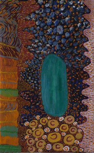
Puntawarri Kapi (Water)
“All around is sandhills and lakes on every side. You can see the grass, but the lakes are all dry. In the middle is Puntawarri waterhole. That’s the jila (snake) place, two jila. They nyupa (spouses), they darlings, man and woman. They sleeping near to Puntawarri. It’s a hole in the ground- that jila will come out of the ground and all the dust will go everywhere. All the dust going everywhere, the dust that flies up when the jila flies up out of its hole. The jila isn’t in that place anymore. It’s gone now but that jila used to stop there.”
– Helen Dale Samson
Puntawarri is an important cultural area located on the middle stretches of the Canning Stock Route and east of the Jigalong Mission (now Jigalong Aboriginal community). It is also the site of an abandoned community, a waterhole, creek and lake. Puntawarri’s close proximity to Jigalong Mission made it a popular site for Martu to visit during the ‘mission days’. Dale was born at Jigalong Mission, and continues to live in the community now located there today. Though she grew up in the dormitory at Jigalong, she spent her weekends and holidays in the bush, camping at sites such as Puntawarri with her extended family. Once married, she lived around Puntawarri, walking and hunting in the surrounding Country.
For many Martu, like Dale’s family, Jigalong Mission was the site where their pujiman (traditional, desert dwelling) lifestyle came to an end from the late 1940s as they transitioned to a life as stockmen and women working in cattle stations in the Pilbara region and beyond. In the wake of the extreme and prolonged drought of the 1960s, the last of the remaining pujimanpa (desert dwellers) were forced to move to missions like Jigalong, where a supply of food and water was assured. There, many Martu were reunited with family members that had already moved in from the desert.
The waterhole at Puntawarri is said to be populated by several kinds of ancestral jila, as referred to by Dale in her account. However the site is best known for its association with the Ngayurnangalku, fearsome ancestral cannibal beings. During the Jukurrpa (Dreaming) the Ngayurnangalku came together from all over the desert, first stopping near Puntawarri on their travels to Kumpupirntily (Kumpupintily, Lake Disappointment). At Kumpupirntily, they had a big meeting to debate whether or not they would continue to live as cannibals, and eventually came to the decision to stop eating people. That night, a female baby cannibal was born to the eastern Ngayurnangalku on the red sandhills at Puntawarri, where she continues to live today as the ‘big mummy’ Ngayurnangalku. Following protocol, the baby also had to be consulted by the group. She determined that the Ngayurnangalku should continue to eat people. Her decision divided the group, and from this point the group from the east continued to live as ‘bad’ cannibals at Kumpupirntily, while the group from the west became ‘good’, thereafter consuming only animals.
111581614164
Untitled
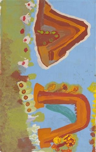
This is Wurta Amy French’s Country- her ‘ngurra’ (home Country, camp). People identify with their ngurra in terms of specific rights and responsibilities, and the possession of intimate knowledge of the physical and cultural properties of one’s Country. Painting ngurra, and in so doing sharing the Jukurrpa (Dreaming) stories and physical characteristics of that place, has today become an important means of cultural maintenance.
Wurta’s ngurra encompasses the Country that she and her family walked in the pujiman (traditional, desert-dwelling) era. At this time Wurta travelled nomadically with her own and other family groups. The Country they traversed encompassed an enormous tract of land, all around the Karlamily (Rudall River) region and through to Tiwa (Canning Stock Route Well 26) .
Wurta was born at Wantili (Warntili, Canning Stock Route Well 25). She grew up, walked and hunted primarily around water sources Pangkartal, Yalpalpa, Walirrlirri, Yanytikuji, Wartararra, Tintinmarran, Pimurlu, Raarki (Canning Stock Route Well 27), and Tiwa. Her family continued to live nomadically before eventually deciding to move to Jigalong Mission along with many other relatives following an extreme and prolonged drought in the 1960s.
Portrayed in this work are features of Wurta’s ngurra, such as the hills, gorges and valleys, warta (trees, vegetation), and the individually named water sources she and her family camped at. Rock holes, waterholes, soaks and springs were all extremely important sites for Martu people during the pujiman period, and are generally depicted with circular forms.
The encyclopaedic knowledge of the location, quality and seasonal availability of the hundreds of water bodies found in one’s Country sustained Martu as they travelled across their Country, hunting and gathering, visiting family, and fulfilling ceremonial obligations. They would traverse very large distances annually, visiting specific areas in the dry and wet season depending on the availability of water and the corresponding cycles of plant and animal life on which hunting and gathering bush tucker was reliant. As they travelled and hunted they would also burn areas of Country, generating a greater diversity of plant and animal life.
111581614162
Wantili
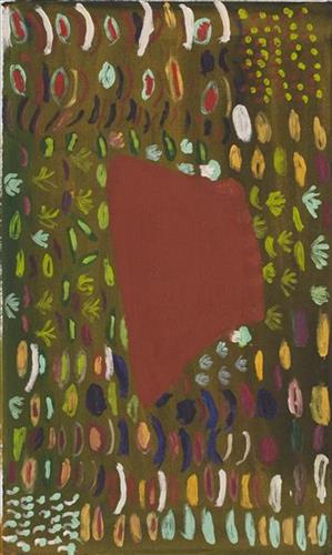
Wantili is a large lyinji (clay pan) near Well 24 on the Canning Stock Route. The area is dominated by claypans surrounded by tuwa (sandhills), and following rain the claypans are filled with water. At that time the site becomes an important place for obtaining fresh water for drinking and bathing.
111581614155
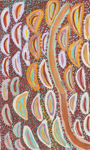
Untitled
This is Jatarr’s Country- her ‘ngurra’ (home Country, camp). People identify with their ngurra in terms of specific rights and responsibilities, and the possession of intimate knowledge of the physical and cultural properties of one’s Country. Painting ngurra, and in so doing sharing the Jukurrpa (Dreaming) stories and physical characteristics of that place, has today become an important means of cultural maintenance.
Jatarr’s ngurra encompasses the Country that she and her family walked in the pujiman (traditional, desert-dwelling) era. At this time Jatarr travelled nomadically with her own and other family groups. The Country they traversed encompassed an enormous tract of land, all around the Karlamily (Rudall River) region and through to Tiwa (Canning Stock Route Well 26) .
Jatarr was born at Jartarrangara. She grew up, walked and hunted primarily around Pangkartal, Yalpalpa, Walirrlirri, Yanytikuji, Wartararra, Tintinmarran, Pulikati, Pimurlu, Raarki (Canning Stock Route Well 27), and Tiwa. Her family continued to live nomadically before eventually deciding to move to Jigalong Mission along with many other relatives following an extreme and prolonged drought in the 1960s.
Portrayed in this work are features of Jatarr’s ngurra, such as the hills, gorges and valleys, warta (trees, vegetation), and the individually named water sources she and her family camped at. Rock holes, waterholes, soaks and springs were all extremely important sites for Martu people during the pujiman period, and are generally depicted with circular forms.
The encyclopaedic knowledge of the location, quality and seasonal availability of the hundreds of water bodies found in one’s Country sustained Martu as they travelled across their Country, hunting and gathering, visiting family, and fulfilling ceremonial obligations. They would traverse very large distances annually, visiting specific areas in the dry and wet season depending on the availability of water and the corresponding cycles of plant and animal life on which hunting and gathering bush tucker was reliant. As they travelled and hunted they would also burn areas of Country, generating a greater diversity of plant and animal life.
111581614120
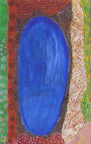
Kumpupirntily (Kumpupintily, Lake Disappointment)
“Clouds here. It’s dry, no water, but still flowers grow.”
– Helen Dale Samson
Kumpupirntily (Kumpupintily, Lake Disappointment) is a stark, flat and unforgiving expanse of blinding salt lake surrounded by sand hills, located in the Little Sandy and Gibson Desert of Western Australia. Kumpupirntily translates to ‘bladder burst’; the lake was formed when the bladder of the Jila Kujarra (Two Snakes) burst here. Jila Kujarra is one of the key Jukurrpa (Dreaming) narratives for the Martu. Though the story belongs to Warnman people, it is shared across the Western Desert with several other language groups. The narrative centres on the travels of two snakes as they are pursued by the Niminjarra, spiritual ancestors of the Warnman people.
Later in the Jukurrpa period the Ngayurnangalku (cannibal beings) made Kumpupirntily their home, where they continue to remain today. For this reason Kumpupirntily is considered one of the most sacred and dangerous sites of the Western Desert. The Ngayurnangalku are fearsome ancestral cannibal beings said to resemble people in their appearance, except for their fangs and long, curved, knife like fingernails they use to catch and hold their human victims. Coming from Natawalu (Canning Stock Route Well 40) in the north, Mundiwinti (Mundawindi) in the west, and from the Country around Kiwirrkurra in the east, the Ngayurnangalku travelled across the desert, stopping near Puntawarri, at Jilukurru (Killagurra Springs, Canning Stock Route Well 17) and at Kupayura (Savory Creek) before finally reaching Kumpupirntily.
At Kumpupirntily, the Ngayurnangalku had a meeting to debate whether or not they would continue to live as cannibals, and eventually came to the decision to stop eating people. That night, a female baby cannibal was born. Following protocol, the baby also had to be consulted by the group. She determined that the Ngayurnangalku should continue to eat people. Her decision divided the group, and from this point the group from the east continued to live as ‘bad’ cannibals at Kumpupirntily, while the group from the west became ‘good’, thereafter consuming only animals.
The cannibal Ngayurnangalku still live beneath the crust of Kumpupirntily lake in an underground world lit by their own sun. They surface only to feed on human flesh, coming in and out of the world we see through a small hill that acts as a gateway between worlds; Yapu Maparnpa (magical hill). Stored with the Ngayurnangalku in their underground world is an arsenal of maparnpa (holding power for sorcery) weapons, as well as deposits of pujurrpa (red ochre) that the Ngayurnangalku use to paint themselves with when they dance.
Several phenomena at Kumpupirntily act as a warning of the imminent appearance of the Ngayurnangalku; still skies, wilany (boomerang-shaped clouds), and the emergence of the parla-parla (type of lizard), smacking their mouths. The vigilance of the Martu as they travel in the Country around Kumpupirntily is so great that several other precautions are followed; fires are not lit, planes and helicopters are not flown directly over the area, and digging in the lake is strongly discouraged. All of these activities are believed to disturb the Ngayurnangalku, causing them to rise from their underground world.
111581615589
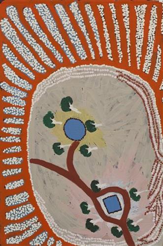
Kaalpa (Well 23)
“Kaalpa is my grandfather ngurra (home) where they walked, hunting bush tuckers. I went there for the first time this year [2018] on a Martumili KJ (Kanyirninpa Jukurrpa) trip. I went hunting there, got a parnajalpa (sand goanna).
When I went there I was pukurlpa (happy). It made you open up your spirt, it feels like home.
It’s got kapi (water) there, a well, jurnu (soak) and tuwa (sandhills)”
– Corban Clause Williams
Kaalpa is a place of great cultural significance, is also referred to as Well 23 on the Canning Stock Route. It is a good hunting place as there is permanent kapi.
111581615587
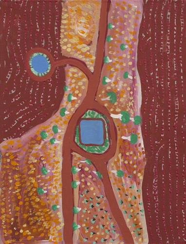
Kaalpa (Well 23)
“Kaalpa is my grandfather ngurra (home) where they walked, hunting bush tuckers. I went there for the first time this year [2018] on a Martumili KJ (Kanyirninpa Jukurrpa) trip. I went hunting there, got a parnajalpa (sand goanna).
When I went there I was pukurlpa (happy). It made you open up your spirt, it feels like home.
It’s got kapi (water) there, a well, jurnu (soak) and tuwa (sandhills)”
– Corban Clause Williams
Kaalpa is a place of great cultural significance, is also referred to as Well 23 on the Canning Stock Route. It is a good hunting place as there is permanent kapi.
111581615793
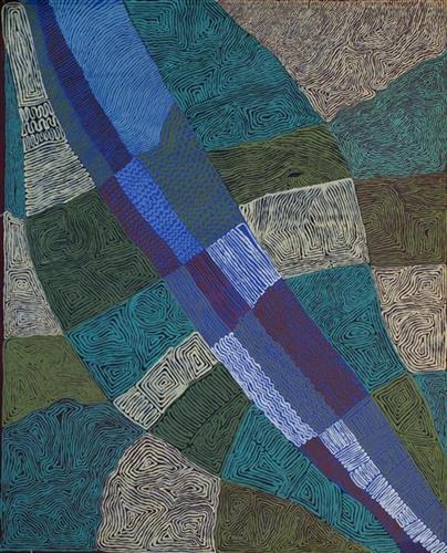
Karlamilyi- Desmond Taylor
“This is in the Karlamilyi River (Rudall River) area. The sand dunes run from the East to the West and stop at the river’s edge on each side. Where the sand dunes stop, the river was created by the Jila Kujarra (Two Snakes) that went east to Nyayartakujarra (Ngayarta Kujarra, Lake Dora).
North of Karlamilyi River there’s a series of claypans in that Country, big claypans and small claypans. After it’s rained they all get filled up. Walyji (white gum) grows around the claypans. It’s a camping area for Warnman people. They used to get water there and also from the Karlamilyi River area.
You can see that blue water along the Karlamilyi River, and the red tuwa (sandhills). As you fly over that Country you will see the designs on the ground in the different formations and colours. That’s the land of my family who are the ancestral owners of Karlamilyi.”
– Desmond Taylor
Karlamilyi is Warnman Country, located in the very heart of the Martu homelands. The Karlamilyi region is Desmond’s ngurra (home Country, camp) through his parents and grandparents, and he possesses a great deal of knowledge of the region’s physical elements, resource distribution, and Jukurrpa (Dreaming) narratives.
The region is situated southwest of the Great Sandy Desert and northeast of the Little Sandy Desert. Spanning through the region is the epic Karlamilyi River, which runs north into Nyayartakujarra, a large salt lake. The Broadhurst and Fingoon Ranges extend diagonally across the river’s path. The landscape is striking for its abundance of gorges and valleys carved by ice age glaciers, rugged cliffs, red tali (sand dunes), grasslands, sandstone and quartz rocky outcrops, and salt lakes.
Across the whole region are hundreds of water sources; including waterholes, creeks, soaks, lakes, pools and rockholes. Lining the rivers are coolabah, walyji (river gum), yulbah (bats wing coral tree), and several species of acacia and hakea. Jalkuran (paperbark), kurrulyu/ mijarrpa (bloodwood) and jawirli (quandong) are found in the region’s valleys, and wikirrpa (desert oaks) and grasses in the sandplains. The area is abundant with bird species, jila (snakes), maruntu (goannas), red kangaroos and warlpaju (rock wallabies). The region is also home to remote aboriginal communities Punmu and Parnngurr.
According to two of the central Martu Jukurrpa narratives, the Karlamilyi River and its surrounds were created by the ancestral beings Jila Kujarra and the Wati Kujarra (Two Goanna Men) as they travelled across the lands.
111581617601
Untitled
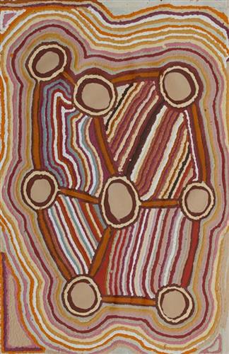
This is Kumpaya’s Country- her ‘ngurra’ (home Country, camp). People identify with their ngurra in terms of specific rights and responsibilities, and the possession of intimate knowledge of the physical and cultural properties of one’s Country. Painting ngurra, and in so doing sharing the Jukurrpa (Dreaming) stories and physical characteristics of that place, has today become an important means of cultural maintenance.
Kumpaya’s ngurra encompasses the Country that she and her family walked in the pujiman (traditional, desert-dwelling) era. At this time she travelled nomadically with her own and other family groups, traversing an enormous tract of land around the middle section of the Canning Stock Route, and between Punmu Aboriginal community and Kiwirrkura, more than 500 kilometres eastward.
Kumpaya was born close to Kiwirrkurra, a rockhole located in the Gibson Desert and to the south west of Lake McKay. She grew up, walked and hunted primarily around this area. As a young woman Kumpaya travelled westward, through to Kunawarritji (Canning Stock Route Well 33). She continued to live nomadically before eventually deciding to move to Jigalong Mission along with many other relatives following an extreme and prolonged drought in the 1960s.
Portrayed in this work are features of Kumpaya’s ngurra, such as the striking salt lakes, dominant permanent red tali (sandhills), warta (trees, vegetation), and the individually named water sources she and her family camped at. These include Luurnkurangu, Karingkarra , Katarta, Pinkari, Pintu-pintu, Yanjiwara, Kunalimpi, Juntu-juntu (Canning Stock Route Well 30), Warla-warla (Canning Stock Route Well 31), Kunawarritji, Kinyu (Canning Stock Route Well 35), Natawalu (Canning Stock Route Well 40), and Kupankurlu. Rock holes, waterholes, soaks and springs were all extremely important sites for Martu people during the pujiman period, and are generally depicted with circular forms.
The encyclopaedic knowledge of the location, quality and seasonal availability of the hundreds of water bodies found in one’s Country sustained Martu as they travelled across their Country, hunting and gathering, visiting family, and fulfilling ceremonial obligations. They would traverse very large distances annually, visiting specific areas in the dry and wet season depending on the availability of water and the corresponding cycles of plant and animal life on which hunting and gathering bush tucker was reliant. As they travelled and hunted they would also burn areas of Country, generating a greater diversity of plant and animal life.