111582316972


Kaalpa (Kalypa, Canning Stock Route Well 23)

“Kaalpa (Kalypa, Canning Stock Route Well 23) is my grandfather’s Country. There’s a waterhole there, Kaalpa waterhole. It’s my two pops’ Country. They been walking around, hunting around Kaalpa. You can see a yapu (rock), warla (lake), claypans, karru (creek) and tuwa (sandhills) there. It’s on the [Canning] Stock Route, it’s Well 23.  

In pujiman (traditional, desert dwelling) days, pujimanpa (desert born people) walking around all this Country. My pops told me about that place, a big flat area, parlkarra (flat country) good for hunting parnajarrpa (goanna), lunki (witchetty grub), lungkurta (blue tongue lizard), wamurla (bush tomato), jinyjiwirrilyi (wild gooseberry). Kaalpa is a busy place for emus getting a drink. 

I went [to Kaalpa] for the first time [in 2018] on a Martumili KJ [Kanyirninpa Jukurrpa] trip. I went hunting there, got a parnajarrpa. When I went there, I was pukurlpa (happy). It made you open up your spirit, it feels like home.”

 – Corban Clause Williams

Kaalpa is a permanent water source located northeast of Kumpupirntily (Kumpupintily, Lake Disappointment). This site is a place of great cultural significance, and is also known for good hunting. Adjacent to the waterhole is a hill of the same name. The landscape around Kaalpa is parlkarra (flat country), bordered by tali (sandhills) stretching as far as Windy Corner, northeast and towards the border of Western Australia and the Northern Territory. The large and dangerous Jukurrpa (Dreamtime) mosquito and fly beings partially created the landforms in this area and continue to live underground here.

Kaalpa also features in the Minyipuru (Jakulyukulyu, Seven Sisters) Jukurrpa, a central creation narrative for Martu, Ngaanyatjarra, Pitjantjatjara and Yankunytjatjara people that is associated with the seasonal Pleiades star constellation. At Kaalpa the Minyipuru met a group of men; it was the first time either group had seen members of the opposite sex. The men tried to grab the women, but the Minyipuru chased them, hitting them with their digging sticks and leaving them lying there as they continued travelling east.

Relayed in song, dance, stories and paintings, Minyipuru serves as a creation narrative, a source of information relating to the physical properties of the land, and an embodiment of Aboriginal cultural laws. Beginning in Roebourne on the west coast of Western Australia, the story morphs in its movement eastward across the land, following the women as they walk, dance, and even fly from waterhole to waterhole. As they travel the women camp, sing, wash, dance and gather food, leaving markers in the landscape and creating landforms that remain to this day, such as groupings of rocks and trees, grinding stones and seeds. During the entirety of their journey the women are pursued by a lustful old man, Yurla, although interactions with other animals, groups of men, and spirit beings are also chronicled in the narrative.

The intersection of the Canning Stock Route with Kaalpa also made this a site of early contact with Europeans for many Martu then living a pujiman life in the desert. Following the route’s construction, Martu encountered Europeans and other Martu working as cattle drovers as they would travel up and down the Stock Route from water source to water source. Increasingly, pujimanpa followed the route to newly established ration depots, mission and pastoral stations. They were drawn to the route in search of food, by a sense of curiosity, or by loneliness. By the late 1950s and early 1960s, most of the desert family groups had left the desert. Eventually, these factors combined with an extreme and prolonged drought in the 1960s to prompt the few remaining pujimanpa to move in from the desert.

111582316971


Kaalpa (Kalypa, Canning Stock Route Well 23)

“Kaalpa (Kalypa, Canning Stock Route Well 23) is my grandfather’s Country. There’s a waterhole there, Kaalpa waterhole. It’s my two pops’ Country. They been walking around, hunting around Kaalpa. You can see a yapu (rock), warla (lake), claypans, karru (creek) and tuwa (sandhills) there. It’s on the [Canning] Stock Route, it’s Well 23.  

In pujiman (traditional, desert dwelling) days, pujimanpa (desert born people) walking around all this Country. My pops told me about that place, a big flat area, parlkarra (flat country) good for hunting parnajarrpa (goanna), lunki (witchetty grub), lungkurta (blue tongue lizard), wamurla (bush tomato), jinyjiwirrilyi (wild gooseberry). Kaalpa is a busy place for emus getting a drink. 

I went [to Kaalpa] for the first time [in 2018] on a Martumili KJ [Kanyirninpa Jukurrpa] trip. I went hunting there, got a parnajarrpa. When I went there, I was pukurlpa (happy). It made you open up your spirit, it feels like home.”

 – Corban Clause Williams

Kaalpa is a permanent water source located northeast of Kumpupirntily (Kumpupintily, Lake Disappointment). This site is a place of great cultural significance, and is also known for good hunting. Adjacent to the waterhole is a hill of the same name. The landscape around Kaalpa is parlkarra (flat country), bordered by tali (sandhills) stretching as far as Windy Corner, northeast and towards the border of Western Australia and the Northern Territory. The large and dangerous Jukurrpa (Dreamtime) mosquito and fly beings partially created the landforms in this area and continue to live underground here.

Kaalpa also features in the Minyipuru (Jakulyukulyu, Seven Sisters) Jukurrpa, a central creation narrative for Martu, Ngaanyatjarra, Pitjantjatjara and Yankunytjatjara people that is associated with the seasonal Pleiades star constellation. At Kaalpa the Minyipuru met a group of men; it was the first time either group had seen members of the opposite sex. The men tried to grab the women, but the Minyipuru chased them, hitting them with their digging sticks and leaving them lying there as they continued travelling east.

Relayed in song, dance, stories and paintings, Minyipuru serves as a creation narrative, a source of information relating to the physical properties of the land, and an embodiment of Aboriginal cultural laws. Beginning in Roebourne on the west coast of Western Australia, the story morphs in its movement eastward across the land, following the women as they walk, dance, and even fly from waterhole to waterhole. As they travel the women camp, sing, wash, dance and gather food, leaving markers in the landscape and creating landforms that remain to this day, such as groupings of rocks and trees, grinding stones and seeds. During the entirety of their journey the women are pursued by a lustful old man, Yurla, although interactions with other animals, groups of men, and spirit beings are also chronicled in the narrative.

The intersection of the Canning Stock Route with Kaalpa also made this a site of early contact with Europeans for many Martu then living a pujiman life in the desert. Following the route’s construction, Martu encountered Europeans and other Martu working as cattle drovers as they would travel up and down the Stock Route from water source to water source. Increasingly, pujimanpa followed the route to newly established ration depots, mission and pastoral stations. They were drawn to the route in search of food, by a sense of curiosity, or by loneliness. By the late 1950s and early 1960s, most of the desert family groups had left the desert. Eventually, these factors combined with an extreme and prolonged drought in the 1960s to prompt the few remaining pujimanpa to move in from the desert.

111582317354


Boundaries, Kiriwirri

“My ancestors lived in the Great Sandy Desert where they used to hunt, gather bush tucker and live for many, many years. During the time living in the desert, growing their kids up, watching family members passing by, it was their home (Ngurra) for generations. Hearing stories from my grandfather, especially the story of my grandmothers Country called Kiriwirri. Brings back memories of how she lived in her country, it’s like being a part of the journey when she walked and lived.

Now I’m painting about my generation and my Country. Through my art it gives me connection and belonging. Stories go a long way, when we talk even just sitting around the fire listening to our elders, it’s a big step for our generation in this time. To carry on that tradition and story and culture – pass it to the next generation.

Painting is like a door to a new world or new language. Most of the world don’t know where Martu people come from and live. Painting guides people to learn about Martu.  I love painting that’s my passion and also telling stories… it helps me connect to where my grandmother was born and lived. I paint bush fires, burning (waru), new growth and also, boundaries.

All Martu people have boundaries in their Country, so that they can know that this is my area, my part of my Country and share with others so they can understand and know where people came from.

In the Great Sandy Desert there is a lot of boundaries and knowing about the boundaries means you will feel that you are connected to that ngurra. Boundaries are important to Martu people so they can relate to each family tribe. It’s important to know.”

Derrick Butt, 2024

Kiriwirri is a soak located in the Percival Lakes region of Western Australia’s Great Sandy Desert. The site was a popular camping area during the pujiman (traditional, desert dwelling) era due to its reliable water source and the abundance of minyarra (bush onion) found in the area. Kiriwirri is also a site visited by the Wati Kujarra (Two Goanna Men), ancestral beings responsible for the creation of many land features in Martu Country and beyond in a key Jukurrpa (Dreaming) narrative. The Wati Kujarra existed as half men, half goanna who travelled, hunted, and burned Country together.

During the pujiman period, Martu would traverse very large distances annually in small family groups, moving seasonally from water source to water source, and hunting and gathering bush tucker as they went. At this time, knowledge of water sources was critical for survival, and today Martu Country is still defined in terms of the location and type of water. Each of the hundreds of claypans, rockholes, waterholes, soaks and springs found in the Martu desert homelands is known by name, location, quality and seasonal availability through real life experience and the recounting of Jukurrpa narratives. 

Soaks, or soakwaters, derive their name from the manner in which their waters generally seep into the sand from below stores, sometimes as part of an ephemeral river or creek. Soaks were an especially important source of water during the pujiman era, being the most dependable water source in times of drought. Water was obtained from soaks by scooping away the sand with a piti (timber bowls used for carrying food and water) until clear water gathered at the base of the hole, sometimes at a depth of several metres. 

111582317359


Kulyakartu

“Long time ago I been there. It is my grandmother’s, grandfather’s, father’s, [and] mother’s country, Kulyakartu.  I am painting this particular place. It keeps me connected, [gives me a] sense of belonging [to] tell my grandmother’s story through my art.  Where she was born, I’m a part of that. 

It makes me feel proud painting.  Most important is telling the story behind the painting so people can understand where I am coming from.  Kulyakartu is our ngurra (home Country, camp).  I will continue telling the story through my art.”

– Derrick Butt

This painting depicts Kulyakartu, Derrick’s ancestral ngurra (home Country, camp). Kulyakartu is a large area in the far north of the Martu homelands, near the Percival Lakes region of Western Australia’s Great Sandy Desert. Kulyakartu is mostly flat grass Country, and is known as a good hunting area. In particular, parnajarrpa (goanna), wild cats, and lunki (witchetty grub) are found in abundance here. In the wantajarra (wet season) the dry lakes in the region fill with water.

111582317358


Kulyakartu

“Long time ago I been there. It is my grandmother’s, grandfather’s, father’s, [and] mother’s country, Kulyakartu.  I am painting this particular place. It keeps me connected, [gives me a] sense of belonging [to] tell my grandmother’s story through my art.  Where she was born, I’m a part of that. 

It makes me feel proud painting.  Most important is telling the story behind the painting so people can understand where I am coming from.  Kulyakartu is our ngurra (home Country, camp).  I will continue telling the story through my art.”

– Derrick Butt

This painting depicts Kulyakartu, Derrick’s ancestral ngurra (home Country, camp). Kulyakartu is a large area in the far north of the Martu homelands, near the Percival Lakes region of Western Australia’s Great Sandy Desert. Kulyakartu is mostly flat grass Country, and is known as a good hunting area. In particular, parnajarrpa (goanna), wild cats, and lunki (witchetty grub) are found in abundance here. In the wantajarra (wet season) the dry lakes in the region fill with water.

111582317357


Waru (fire)

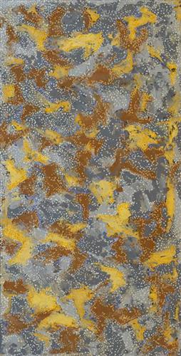
This work depicts the practice of fire burning as it continues to be used today through the Martu homelands. Over thousands of years, as Martu travelled and hunted on foot they would burn tracts of land, using waru (fire) as a means to assist with hunting and to encourage regenerative growth. Whilst fire burning practices have modernised in recent times, with Martu burning areas close to Aboriginal communities and along roads, or else further afield using helicopters and 4WDs with Indigenous ranger group Karnyirninpa Jukurrpa (KJ), the same objectives are met as those during pujiman (traditional, desert dwelling) times.

Targeted waru is an important tool in animal tracking. Small burns are lit to clear vegetation, expose burrows, and to allow for access to walk and track readily in exposed sands. Fires are typically burnt during cooler weather in small, controlled areas, reducing the risk of unmanageable, spontaneous bush fires whilst simultaneously providing diverse regenerating habitats. Remaining is a defined mosaic fire scar pattern in the land, across tali (sand dunes), linyji (clay pans), parulyukurru (spinifex country) and pila (sandy plains). This patterning is clearly visible from an aerial perspective, and becomes even more defined as new growth emerges. 

The patchwork nature of regrowth is aligned with the Martu cycle of burning and regrowth and its five distinct phases. First is nyurnma (freshly burnt Country), followed after the rains by waru-waru, when young, bright green plants start to grow. Nyukura occurs between one and three years after burning, when plants have matured and are fruiting and seeding. Manguu is four to six years post burning, when spinifex has matured to the point that it can be burned once again. Finally, kunarka signifies the time when spinifex and other plant species have become old growth, and pose a risk of destructive bushfires.

111582317356


Waru (fire)

This work depicts the practice of fire burning as it continues to be used today through the Martu homelands. Over thousands of years, as Martu travelled and hunted on foot they would burn tracts of land, using waru (fire) as a means to assist with hunting and to encourage regenerative growth. Whilst fire burning practices have modernised in recent times, with Martu burning areas close to Aboriginal communities and along roads, or else further afield using helicopters and 4WDs with Indigenous ranger group Karnyirninpa Jukurrpa (KJ), the same objectives are met as those during pujiman (traditional, desert dwelling) times.

Targeted waru is an important tool in animal tracking. Small burns are lit to clear vegetation, expose burrows, and to allow for access to walk and track readily in exposed sands. Fires are typically burnt during cooler weather in small, controlled areas, reducing the risk of unmanageable, spontaneous bush fires whilst simultaneously providing diverse regenerating habitats. Remaining is a defined mosaic fire scar pattern in the land, across tali (sand dunes), linyji (clay pans), parulyukurru (spinifex country) and pila (sandy plains). This patterning is clearly visible from an aerial perspective, and becomes even more defined as new growth emerges. 

The patchwork nature of regrowth is aligned with the Martu cycle of burning and regrowth and its five distinct phases. First is nyurnma (freshly burnt Country), followed after the rains by waru-waru, when young, bright green plants start to grow. Nyukura occurs between one and three years after burning, when plants have matured and are fruiting and seeding. Manguu is four to six years post burning, when spinifex has matured to the point that it can be burned once again. Finally, kunarka signifies the time when spinifex and other plant species have become old growth, and pose a risk of destructive bushfires.

111582317355


Waru (fire)

This work depicts the practice of fire burning as it continues to be used today through the Martu homelands. Over thousands of years, as Martu travelled and hunted on foot they would burn tracts of land, using waru (fire) as a means to assist with hunting and to encourage regenerative growth. Whilst fire burning practices have modernised in recent times, with Martu burning areas close to Aboriginal communities and along roads, or else further afield using helicopters and 4WDs with Indigenous ranger group Karnyirninpa Jukurrpa (KJ), the same objectives are met as those during pujiman (traditional, desert dwelling) times.

Targeted waru is an important tool in animal tracking. Small burns are lit to clear vegetation, expose burrows, and to allow for access to walk and track readily in exposed sands. Fires are typically burnt during cooler weather in small, controlled areas, reducing the risk of unmanageable, spontaneous bush fires whilst simultaneously providing diverse regenerating habitats. Remaining is a defined mosaic fire scar pattern in the land, across tali (sand dunes), linyji (clay pans), parulyukurru (spinifex country) and pila (sandy plains). This patterning is clearly visible from an aerial perspective, and becomes even more defined as new growth emerges. 

The patchwork nature of regrowth is aligned with the Martu cycle of burning and regrowth and its five distinct phases. First is nyurnma (freshly burnt Country), followed after the rains by waru-waru, when young, bright green plants start to grow. Nyukura occurs between one and three years after burning, when plants have matured and are fruiting and seeding. Manguu is four to six years post burning, when spinifex has matured to the point that it can be burned once again. Finally, kunarka signifies the time when spinifex and other plant species have become old growth, and pose a risk of destructive bushfires.

111582317353


Boundaries, Kiriwirri

“My ancestors lived in the Great Sandy Desert where they used to hunt, gather bush tucker and live for many, many years. During the time living in the desert, growing their kids up, watching family members passing by, it was their home (Ngurra) for generations. Hearing stories from my grandfather, especially the story of my grandmothers Country called Kiriwirri. Brings back memories of how she lived in her country, it’s like being a part of the journey when she walked and lived.

Now I’m painting about my generation and my Country. Through my art it gives me connection and belonging. Stories go a long way, when we talk even just sitting around the fire listening to our elders, it’s a big step for our generation in this time. To carry on that tradition and story and culture – pass it to the next generation.

Painting is like a door to a new world or new language. Most of the world don’t know where Martu people come from and live. Painting guides people to learn about Martu.  I love painting that’s my passion and also telling stories… it helps me connect to where my grandmother was born and lived. I paint bush fires, burning (waru), new growth and also, boundaries.

All Martu people have boundaries in their Country, so that they can know that this is my area, my part of my Country and share with others so they can understand and know where people came from.

In the Great Sandy Desert there is a lot of boundaries and knowing about the boundaries means you will feel that you are connected to that ngurra. Boundaries are important to Martu people so they can relate to each family tribe. It’s important to know.”

Derrick Butt, 2024

Kiriwirri is a soak located in the Percival Lakes region of Western Australia’s Great Sandy Desert. The site was a popular camping area during the pujiman (traditional, desert dwelling) era due to its reliable water source and the abundance of minyarra (bush onion) found in the area. Kiriwirri is also a site visited by the Wati Kujarra (Two Goanna Men), ancestral beings responsible for the creation of many land features in Martu Country and beyond in a key Jukurrpa (Dreaming) narrative. The Wati Kujarra existed as half men, half goanna who travelled, hunted, and burned Country together.

During the pujiman period, Martu would traverse very large distances annually in small family groups, moving seasonally from water source to water source, and hunting and gathering bush tucker as they went. At this time, knowledge of water sources was critical for survival, and today Martu Country is still defined in terms of the location and type of water. Each of the hundreds of claypans, rockholes, waterholes, soaks and springs found in the Martu desert homelands is known by name, location, quality and seasonal availability through real life experience and the recounting of Jukurrpa narratives. 

Soaks, or soakwaters, derive their name from the manner in which their waters generally seep into the sand from below stores, sometimes as part of an ephemeral river or creek. Soaks were an especially important source of water during the pujiman era, being the most dependable water source in times of drought. Water was obtained from soaks by scooping away the sand with a piti (timber bowls used for carrying food and water) until clear water gathered at the base of the hole, sometimes at a depth of several metres. 

111582317352


Boundaries, Kiriwirri

“My ancestors lived in the Great Sandy Desert where they used to hunt, gather bush tucker and live for many, many years. During the time living in the desert, growing their kids up, watching family members passing by, it was their home (Ngurra) for generations. Hearing stories from my grandfather, especially the story of my grandmothers Country called Kiriwirri. Brings back memories of how she lived in her country, it’s like being a part of the journey when she walked and lived.

Now I’m painting about my generation and my Country. Through my art it gives me connection and belonging. Stories go a long way, when we talk even just sitting around the fire listening to our elders, it’s a big step for our generation in this time. To carry on that tradition and story and culture – pass it to the next generation.

Painting is like a door to a new world or new language. Most of the world don’t know where Martu people come from and live. Painting guides people to learn about Martu.  I love painting that’s my passion and also telling stories… it helps me connect to where my grandmother was born and lived. I paint bush fires, burning (waru), new growth and also, boundaries.

All Martu people have boundaries in their Country, so that they can know that this is my area, my part of my Country and share with others so they can understand and know where people came from.

In the Great Sandy Desert there is a lot of boundaries and knowing about the boundaries means you will feel that you are connected to that ngurra. Boundaries are important to Martu people so they can relate to each family tribe. It’s important to know.”

Derrick Butt, 2024

Kiriwirri is a soak located in the Percival Lakes region of Western Australia’s Great Sandy Desert. The site was a popular camping area during the pujiman (traditional, desert dwelling) era due to its reliable water source and the abundance of minyarra (bush onion) found in the area. Kiriwirri is also a site visited by the Wati Kujarra (Two Goanna Men), ancestral beings responsible for the creation of many land features in Martu Country and beyond in a key Jukurrpa (Dreaming) narrative. The Wati Kujarra existed as half men, half goanna who travelled, hunted, and burned Country together.

During the pujiman period, Martu would traverse very large distances annually in small family groups, moving seasonally from water source to water source, and hunting and gathering bush tucker as they went. At this time, knowledge of water sources was critical for survival, and today Martu Country is still defined in terms of the location and type of water. Each of the hundreds of claypans, rockholes, waterholes, soaks and springs found in the Martu desert homelands is known by name, location, quality and seasonal availability through real life experience and the recounting of Jukurrpa narratives. 

Soaks, or soakwaters, derive their name from the manner in which their waters generally seep into the sand from below stores, sometimes as part of an ephemeral river or creek. Soaks were an especially important source of water during the pujiman era, being the most dependable water source in times of drought. Water was obtained from soaks by scooping away the sand with a piti (timber bowls used for carrying food and water) until clear water gathered at the base of the hole, sometimes at a depth of several metres.