111582214050


Pitu (Separation Well)

“Pitu, soak, big one. Water there all the time. Pitu, the place for our whole family. [As a young girl] I walked around and went east back to my dad’s area, to Pitu and Kulilu, Nakaly and Kunapila. Then I was a teenager. My Country is Pitu and Nakaly, that’s my Country.

This man here, he came through here in the Dreamtime, walking right up through here and then he flew. Other one, a man and a woman, coming behind him, following him right up through here and then finish, I don’t know where they’ve gone. There is one more woman, going across here. Those three people walked through this Country and disappeared when they flew somewhere. They went forever. That was in the Dreamtime when they were walking around.”

 – Ngamaru Bidu, as translated by Ngalangka Nola Taylor

Pitu (Separation Well) is an important cultural site and large soak located yulparirra (south) of Wuranu (Canning Stock Route Well 29) and Kulilu rockhole and soak. As a site where fresh water was available all year, Pitu was an important camp and a meeting place for Kartujarra and Manyjilyjarra people during the pujiman (traditional, desert dwelling) era. At this time, knowledge of water sources was critical for survival, and today Martu Country is still defined in terms of the location and type of water. Each of the hundreds of claypans, rockholes, waterholes, soaks and springs found in the Martu desert homelands is known by name, location, quality and seasonal availability through real life experience and the recounting of Jukurrpa (Dreaming) narratives. 

Pitu lies within Ngamaru’s ngurra (home Country, camp), the area which she knew intimately and travelled extensively with her family in her youth. Ngamaru’s family name, ‘Bidu’, derives from this place name. In her account of the area, Ngamaru relates a Jukurrpa narrative that occurred in and around Pitu. The term Jukurrpa is often translated in English as the ‘Dreaming’, or ‘Dreamtime’. It refers generally to the period in which the world was created by ancestral beings, who assumed both human and nonhuman forms. These beings shaped what had been a formless landscape; creating waters, plants, animals, and people. At the same time they provided cultural protocols for the people they created, as well as rules for interacting with the natural environment. At their journey’s end, the ancestral beings transformed themselves into important waters, hills, rocks, and even constellations.

111582214049


Untitled

This is Bugai’s Country- her ‘ngurra’ (home Country, camp). People identify with their ngurra in terms of specific rights and responsibilities, and the possession of intimate knowledge of the physical and cultural properties of one’s Country. Painting ngurra, and in so doing sharing the Jukurrpa (Dreaming) stories and physical characteristics of that place, has today become an important means of cultural maintenance. 

Bugai’s ngurra encompasses the Country that she and her family walked in the pujiman (traditional, desert-dwelling) era. At this time Bugai travelled nomadically with her own and other family groups, most notably the Bidu family. The Country they traversed encompassed an enormous tract of land, with an aerial distance of more than 600 kilometres, from present day Balfour Downs Station to Kunawarritji (Canning Stock Route Well 33). Bugai was born at Pulkinya. She grew up, walked and hunted primarily around Parnngurr, Punmu, Kun Kun (Kuny-kuny) and Kunawarritji. As a young woman Bugai travelled with her husband through the Karlamilyi (Rudall River) region and up and down the Canning Stock Route, where she first met cattle drovers. She continued to live nomadically before eventually deciding to move to Jigalong Mission along with many other relatives following an extreme and prolonged drought in the 1960s. 

Portrayed in this work are features of Bugai’s ngurra, such as the striking salt lakes, dominant permanent red tali (sandhills), warta (trees, vegetation), and the individually named water sources Bugai and her family camped at. These include Parnngurr, Martilirri, Wangkakalu, Kurta-kurta (Camel Rock), Pimurlu, Jilkupuka (Canning Stock Route Well 21), Kaalpa (Canning Stock Route Well 23), Kartarru (Canning Stock Route Well 24), Wantili (Warntili, Canning Stock Route Well 25), Tiwa (Canning Stock Route Well 26), Partujarrapirri, Raarki (Canning Stock Route Well 27), Wuranu (Canning Stock Route Well 29), Juntu- juntu (Canning Stock Route Well 30), and Kunawarritji. Rock holes, waterholes, soaks and springs were all extremely important sites for Martu people during the pujiman period, and are generally depicted with circular forms. 

The encyclopaedic knowledge of the location, quality and seasonal availability of the hundreds of water bodies found in one’s Country sustained Martu as they travelled across their Country, hunting and gathering, visiting family, and fulfilling ceremonial obligations. They would traverse very large distances annually, visiting specific areas in the dry and wet season depending on the availability of water and the corresponding cycles of plant and animal life on which hunting and gathering bush tucker was reliant. As they travelled and hunted they would also burn areas of Country, generating a greater diversity of plant and animal life.

111582214048


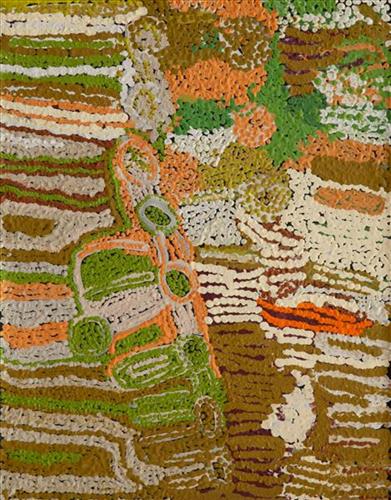
Bush tucker and wild flower

“I make a painting and it’s a wild bush flower, desert flower! And bush tucker. I do painting for bush tucker and wild flower.”

– Danita Wise

Depicted in this work are traditional types of bush tucker, their floral habitats, and their related hunting and gathering methods. During the pujiman (traditional, desert dwelling) period, Martu would traverse very large distances annually in small family groups, moving seasonally from water source to water source, and hunting and gathering bush tucker as they went. Whilst desert life has moved away from mobile hunter-gatherer subsistence throughout the course of the twentieth century, bush tucker continues to be a significant component of the modern Martu diet. Hunting and gathering bush tucker remains equally valuable as an important cultural practice that is passed on intergenerationally. Though hunting and gathering implements have been modernised, methods of harvesting, tracking and the use of fire burning to drive animals from their retreats are still commonly practiced today. 

Typically, animals hunted for their kuwiyi (meat) include kirti-kirti (euro kangaroo) and marlu (plains kangaroo), parnajarrpa (sand goanna), kipara (Australian bustard, bush turkey) and karlaya (emu). Lunki (witchetty grub) and wuukurta (honey ants) are dug from tree and bush trunks, or from underground nests. Popular mayi (plant food) includes minyarra (bush onion), collected from small, grass like plants; root vegetables dug from underground such as kulyu and mata (types of bush potato); and seeds such as kalaru (samphire, salt bush), yuwinyji, and marnkalpa (spinifex species). Jawirli (quondong), wamurla (bush tomatoes), jinyjiwirrily (wild gooseberry), ngaputa (melon), and karlkula (bush banana) are some of the most popular bush fruits. These are often collected in the wantajarra (cool season) and tuulpara (spring) months, along with juri (sweet) botanical gums and wama (nectar), obtained from various plant species. 

Traditional tools used for hunting and gathering bush tucker were carved from wanari (mulga), mulunturu (desert oak), yurungkura (river red gum) and mijarrpa (bloodwoods), and included kurlata (spears), jurna (hitting stick), karli (boomerangs), wana (digging-sticks), piti (timber bowls used for carrying food and water), and jiwa (grinding stones for grinding seeds into flour). While carved objects retain enormous social and ceremonial importance in Martu life, they are no longer used for hunting and gathering.

Over half a million square kilometres of mangroves, off shore islands, deep gorges, mountain ranges, desert sand dunes and river pools ensure the Pilbara’s flora is as diverse as the landscape. Plants and flowers in the Pilbara have evolved unique adaptations to survive in an arid climate that receives most of its rainfall during summer by way of tropical cyclones. Watercourses are lined with river red gums, coolibah, silver cadjeput and desert bloodwood trees. Gorges contain permanent water supplies to support moisture loving plants like the common rock fig and rock kurrajong. From July to September wildflowers of all colours, sizes and shapes, like the unmistakeable Sturt’s desert pea, fluffy mulla mulla, the tall majestic Ashburton pea or any number of the 65 species of Acacia (wattle) can be seen throughout the region.

111582214047


Untitled

This is Bugai’s Country- her ‘ngurra’ (home Country, camp). People identify with their ngurra in terms of specific rights and responsibilities, and the possession of intimate knowledge of the physical and cultural properties of one’s Country. Painting ngurra, and in so doing sharing the Jukurrpa (Dreaming) stories and physical characteristics of that place, has today become an important means of cultural maintenance. 

Bugai’s ngurra encompasses the Country that she and her family walked in the pujiman (traditional, desert-dwelling) era. At this time Bugai travelled nomadically with her own and other family groups, most notably the Bidu family. The Country they traversed encompassed an enormous tract of land, with an aerial distance of more than 600 kilometres, from present day Balfour Downs Station to Kunawarritji (Canning Stock Route Well 33). Bugai was born at Pulkinya. She grew up, walked and hunted primarily around Parnngurr, Punmu, Kun Kun (Kuny-kuny) and Kunawarritji. As a young woman Bugai travelled with her husband through the Karlamilyi (Rudall River) region and up and down the Canning Stock Route, where she first met cattle drovers. She continued to live nomadically before eventually deciding to move to Jigalong Mission along with many other relatives following an extreme and prolonged drought in the 1960s. 

Portrayed in this work are features of Bugai’s ngurra, such as the striking salt lakes, dominant permanent red tali (sandhills), warta (trees, vegetation), and the individually named water sources Bugai and her family camped at. These include Parnngurr, Martilirri, Wangkakalu, Kurta-kurta (Camel Rock), Pimurlu, Jilkupuka (Canning Stock Route Well 21), Kaalpa (Canning Stock Route Well 23), Kartarru (Canning Stock Route Well 24), Wantili (Warntili, Canning Stock Route Well 25), Tiwa (Canning Stock Route Well 26), Partujarrapirri, Raarki (Canning Stock Route Well 27), Wuranu (Canning Stock Route Well 29), Juntu- juntu (Canning Stock Route Well 30), and Kunawarritji. Rock holes, waterholes, soaks and springs were all extremely important sites for Martu people during the pujiman period, and are generally depicted with circular forms. 

The encyclopaedic knowledge of the location, quality and seasonal availability of the hundreds of water bodies found in one’s Country sustained Martu as they travelled across their Country, hunting and gathering, visiting family, and fulfilling ceremonial obligations. They would traverse very large distances annually, visiting specific areas in the dry and wet season depending on the availability of water and the corresponding cycles of plant and animal life on which hunting and gathering bush tucker was reliant. As they travelled and hunted they would also burn areas of Country, generating a greater diversity of plant and animal life.

111582214041


Wantili (Warntili, Canning Stock Route Well 25)

“That’s my jamu (grandfather) and nanna’s Country. I always go on a ranger trip there with my mum, Thelma Judson, and my little baby brothers, Junior and Jamie Rowlands.”

– Lynette Rowlands

Wantili (Warntili, Canning Stock Route Well 25) is a large round jurnu (soak) and linyji (claypan) near Well 25 on the Canning Stock Route. This site is Kuru’s birthplace, and as such forms an integral part of her ngurra. The area is dominated by claypans surrounded by tuwa (sandhills), and Nyilangkurr, a prominent yapu (hill) is located on the edge of the claypan. Following rain the typically dry claypans are filled with water, with the overflow from nearby waterholes flowing to Wantili. At that time, Wantili becomes an important place for obtaining fresh water for drinking and bathing. Wantili is significant for the fact that at this site Kartujarra, Manyjilyjarra, Putijarra and Warnman people would all come together for ceremonies during the pujiman era. Many jiwa (stones used by women for grinding seeds) from these times can still be found there today. 

Wantili is an incredibly important cultural site, ‘where the creation started.’  (Cyril Whyoulter). In this creation story, the world was initially dark, and people were like rocks, with no arms or legs. Following the sun’s first rising, life-forms become increasingly complex while particular features in the land were created. Beyond these details much of the Jukurrpa (Dreaming) narrative relating to Wantili is ngurlu (sacred, taboo), and only for Martu, but the site is open, and anyone can go there. 

Wantili is also one of the many sites featured in the epic Minyipuru (Jakulyukulyu, Seven Sisters) Jukurrpa story. Minyipuru is a central Jukurrpa narrative for Martu, Ngaanyatjarra, Pitjantjatjara and Yankunytjatjara people that is associated with the seasonal Pleiades star constellation. Relayed in song, dance, stories and paintings, Minyipuru serves as a creation narrative, a source of information relating to the physical properties of the land, and an embodiment of Aboriginal cultural laws. The story follows the movement of a group of women travelling all the way across the desert, beginning at Roebourne on the coast of Western Australia, as they are pursued by Yurla, a lustful old man. As the women travelled, they stopped to rest at many sites to eat, dance, rest and sing, on the way leaving behind an assortment of articles that became formations in the land, such as groupings of rocks and trees, grinding stones and seeds. The sisters rested at Wantili before throwing seeds, then continued their journey far to the east and beyond Martu Country, stopping at various sites through central and South Australia.

The intersection of the Canning Stock Route with Wantili also made this a site of early contact with Europeans for many Martu then living a pujiman life in the desert. Following the route’s construction, Martu encountered Europeans and other Martu working as cattle drovers as they would travel up and down the Stock Route from water source to water source. Increasingly, pujimanpa  (desert dwellers) followed the route to newly established ration depots, mission and pastoral stations. They were drawn to the route in search of food, by a sense of curiosity, or by loneliness. By the late 1950s and early 1960s, most of the desert family groups had left the desert. Eventually, these factors combined with an extreme and prolonged drought in the 1960s to prompt the few remaining pujimanpa to move in from the desert.

111582214038


Untitled

This is Bugai’s Country- her ‘ngurra’ (home Country, camp). People identify with their ngurra in terms of specific rights and responsibilities, and the possession of intimate knowledge of the physical and cultural properties of one’s Country. Painting ngurra, and in so doing sharing the Jukurrpa (Dreaming) stories and physical characteristics of that place, has today become an important means of cultural maintenance. 

Bugai’s ngurra encompasses the Country that she and her family walked in the pujiman (traditional, desert-dwelling) era. At this time Bugai travelled nomadically with her own and other family groups, most notably the Bidu family. The Country they traversed encompassed an enormous tract of land, with an aerial distance of more than 600 kilometres, from present day Balfour Downs Station to Kunawarritji (Canning Stock Route Well 33). Bugai was born at Pulkinya. She grew up, walked and hunted primarily around Parnngurr, Punmu, Kun Kun (Kuny-kuny) and Kunawarritji. As a young woman Bugai travelled with her husband through the Karlamilyi (Rudall River) region and up and down the Canning Stock Route, where she first met cattle drovers. She continued to live nomadically before eventually deciding to move to Jigalong Mission along with many other relatives following an extreme and prolonged drought in the 1960s. 

Portrayed in this work are features of Bugai’s ngurra, such as the striking salt lakes, dominant permanent red tali (sandhills), warta (trees, vegetation), and the individually named water sources Bugai and her family camped at. These include Parnngurr, Martilirri, Wangkakalu, Kurta-kurta (Camel Rock), Pimurlu, Jilkupuka (Canning Stock Route Well 21), Kaalpa (Canning Stock Route Well 23), Kartarru (Canning Stock Route Well 24), Wantili (Warntili, Canning Stock Route Well 25), Tiwa (Canning Stock Route Well 26), Partujarrapirri, Raarki (Canning Stock Route Well 27), Wuranu (Canning Stock Route Well 29), Juntu- juntu (Canning Stock Route Well 30), and Kunawarritji. Rock holes, waterholes, soaks and springs were all extremely important sites for Martu people during the pujiman period, and are generally depicted with circular forms. 

The encyclopaedic knowledge of the location, quality and seasonal availability of the hundreds of water bodies found in one’s Country sustained Martu as they travelled across their Country, hunting and gathering, visiting family, and fulfilling ceremonial obligations. They would traverse very large distances annually, visiting specific areas in the dry and wet season depending on the availability of water and the corresponding cycles of plant and animal life on which hunting and gathering bush tucker was reliant. As they travelled and hunted they would also burn areas of Country, generating a greater diversity of plant and animal life.

111582214034


Wantili (Warntili, Canning Stock Route Well 25)

Wantili (Warntili, Canning Stock Route Well 25) is a large round jurnu (soak) and linyji (claypan) near Well 25 on the Canning Stock Route. The area is dominated by claypans surrounded by tuwa (sandhills), and Nyilangkurr, a prominent yapu (hill) is located on the edge of the claypan. Following rain the typically dry claypans are filled with water, with the overflow from nearby waterholes flowing to Wantili. At that time, Wantili becomes an important place for obtaining fresh water for drinking and bathing. Wantili is significant for the fact that at this site Kartujarra, Manyjilyjarra, Putijarra and Warnman people would all come together for ceremonies during the pujiman (traditional, desert dwelling) era. Many jiwa (stones used by women for grinding seeds) from these times can still be found there today. 

Wantili is an incredibly important cultural site, ‘where the creation started.’ (Cyril Whyoulter). In this creation story, the world was initially dark, and people were like rocks, with no arms or legs. Following the sun’s first rising, life-forms become increasingly complex while particular features in the land were created. Beyond these details much of the Jukurrpa (Dreaming) narrative relating to Wantili is ngurlu (sacred, taboo), and only for Martu, but the site is open, and anyone can go there. 

Wantili is also one of the many sites featured in the epic Minyipuru (Jakulyukulyu, Seven Sisters) Jukurrpa story. Minyipuru is a central Jukurrpa narrative for Martu, Ngaanyatjarra, Pitjantjatjara and Yankunytjatjara people that is associated with the seasonal Pleiades star constellation. Relayed in song, dance, stories and paintings, Minyipuru serves as a creation narrative, a source of information relating to the physical properties of the land, and an embodiment of Aboriginal cultural laws. The story follows the movement of a group of women travelling all the way across the desert, beginning at Roebourne on the coast of Western Australia, as they are pursued by Yurla, a lustful old man. As the women travelled, they stopped to rest at many sites to eat, dance, rest and sing, on the way leaving behind an assortment of articles that became formations in the land, such as groupings of rocks and trees, grinding stones and seeds. The sisters rested at Wantili before throwing seeds, then continued their journey far to the east and beyond Martu Country, stopping at various sites through central and South Australia.

The intersection of the Canning Stock Route with Wantili also made this a site of early contact with Europeans for many Martu then living a pujiman life in the desert. Following the route’s construction, Martu encountered Europeans and other Martu working as cattle drovers as they would travel up and down the Stock Route from water source to water source. Increasingly, pujimanpa (desert dwellers) followed the route to newly established ration depots, mission and pastoral stations. They were drawn to the route in search of food, by a sense of curiosity, or by loneliness. By the late 1950s and early 1960s, most of the desert family groups had left the desert. Eventually, these factors combined with an extreme and prolonged drought in the 1960s to prompt the few remaining pujimanpa to move in from the desert.

111582214006


Bush tucker and wild flower

“I make a painting and it’s a wild bush flower, desert flower! And bush tucker. I do painting for bush tucker and wild flower.”

– Danita Wise

Depicted in this work are traditional types of bush tucker, their floral habitats, and their related hunting and gathering methods. During the pujiman (traditional, desert dwelling) period, Martu would traverse very large distances annually in small family groups, moving seasonally from water source to water source, and hunting and gathering bush tucker as they went. Whilst desert life has moved away from mobile hunter-gatherer subsistence throughout the course of the twentieth century, bush tucker continues to be a significant component of the modern Martu diet. Hunting and gathering bush tucker remains equally valuable as an important cultural practice that is passed on intergenerationally. Though hunting and gathering implements have been modernised, methods of harvesting, tracking and the use of fire burning to drive animals from their retreats are still commonly practiced today. 

Typically, animals hunted for their kuwiyi (meat) include kirti-kirti (euro kangaroo) and marlu (plains kangaroo), parnajarrpa (sand goanna), kipara (Australian bustard, bush turkey) and karlaya (emu). Lunki (witchetty grub) and wuukurta (honey ants) are dug from tree and bush trunks, or from underground nests. Popular mayi (plant food) includes minyarra (bush onion), collected from small, grass like plants; root vegetables dug from underground such as kulyu and mata (types of bush potato); and seeds such as kalaru (samphire, salt bush), yuwinyji, and marnkalpa (spinifex species). Jawirli (quondong), wamurla (bush tomatoes), jinyjiwirrily (wild gooseberry), ngaputa (melon), and karlkula (bush banana) are some of the most popular bush fruits. These are often collected in the wantajarra (cool season) and tuulpara (spring) months, along with juri (sweet) botanical gums and wama (nectar), obtained from various plant species. 

Traditional tools used for hunting and gathering bush tucker were carved from wanari (mulga), mulunturu (desert oak), yurungkura (river red gum) and mijarrpa (bloodwoods), and included kurlata (spears), jurna (hitting stick), karli (boomerangs), wana (digging-sticks), piti (timber bowls used for carrying food and water), and jiwa (grinding stones for grinding seeds into flour). While carved objects retain enormous social and ceremonial importance in Martu life, they are no longer used for hunting and gathering.

Over half a million square kilometres of mangroves, off shore islands, deep gorges, mountain ranges, desert sand dunes and river pools ensure the Pilbara’s flora is as diverse as the landscape. Plants and flowers in the Pilbara have evolved unique adaptations to survive in an arid climate that receives most of its rainfall during summer by way of tropical cyclones. Watercourses are lined with river red gums, coolibah, silver cadjeput and desert bloodwood trees. Gorges contain permanent water supplies to support moisture loving plants like the common rock fig and rock kurrajong. From July to September wildflowers of all colours, sizes and shapes, like the unmistakeable Sturt’s desert pea, fluffy mulla mulla, the tall majestic Ashburton pea or any number of the 65 species of Acacia (wattle) can be seen throughout the region.

111582214002


Untitled

“I like painting. It’s a good way to learn from the old people and keep the stories going.”

 – Cyril Whyoulter

Cyril Whyoulter is one of the most dynamic and exciting practitioners to emerge from the youngest generation of Martumili Artists. He, like his contemporaries, began to paint with his parents, grandparents and extended family, thus fostering an organic process of learning not only about painting techniques, but also specific locations, family histories, traditional ways of life, and Jukurrpa (Dreaming). He has been a key driving force behind a number of major collaborative projects that have promoted the transfer of cultural knowledge through visual arts, including exhibitions; Pujiman (Desert dwelling, traditional) and Wantili (Warntili, Canning Stock Route Well 25).

Stylistically Cyril’s work melds traditional, contemporary, and experimental elements, demonstrating the development of his own aesthetic while continuing to reflect the powerful influence of his elders. Cyril first began drawing with his grandfather Larry Patterson, and later began painting with his mother, Betty Whyoulter, and grandmother and renowned Martumili artist, Bugai Whyoulter. Having collaborated with and worked alongside Bugai in particular, her influence is most readily identifiable in his work.

Frequently depicted in Cyril’s paintings are Jukurrpa narratives, Jila Kujarra (Two Snakes) and Wati Kujarra (Two Goanna Men), as well as various sites forming part of his family’s ngurra (home Country, camp). These sites encompass a large tract of land, ranging from the south western edge of the Karlamilyi (Rudall River) region through to Wantili, and north to the area surrounding Kunawarritji (Canning Stock Route Well 33).  

111582213998


Waterhole

This work depicts a waterhole within the artists’ ngurra (home Country, camp), typically represented with circular forms. Waterholes are sites that require maintenance, including digging to increase flow, clearing out surrounding growth, and cleaning up after sullying by camels or cattle.

During the pujiman (traditional, desert dwelling) period, knowledge of water sources was critical for survival, and today Martu Country is still defined in terms of the location and type of water. Each of the hundreds of claypans, rockholes, waterholes, soaks and springs found in the Martu desert homelands is known through real life experience and the recounting of Jukurrpa (Dreaming) narratives by name, location, quality and seasonal availability. This encyclopedic knowledge extends even to the nature and movement of arterial waterways, and sustained Martu as they travelled across their Country, hunting and gathering, visiting family, and fulfilling ceremonial obligations. They would traverse very large distances annually, visiting specific areas in the dry and wet season depending on the availability of water and the corresponding cycles of plant and animal life on which hunting and gathering bush tucker was reliant.