111582189785


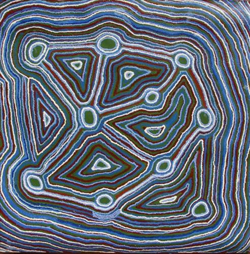
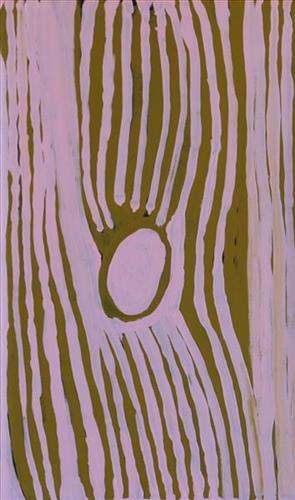
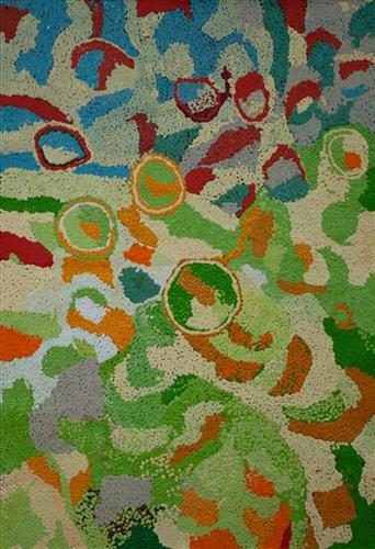
Untitled – Generic Jakayu Biljabu

“I’m really happy when I’m painting my Country. I’m proud as I follow my Country, I’m holding on to my Country. That’s my water in the East. I’m painting my Country. It’s not someone else’s, it’s my Country. I’m looking after my Country. I’m showing my family the Country. I feel privileged that I can see it. As I watch my children I’m really happy for them. I’m watching them all while they’re working on the Country. I’m so proud of them. I’m looking after them and now I feel fulfilled.”  

– Jakayu Biljabu as translated by Kanyirninpa Jukurrpa


This is Jakayu’s Country- her ‘ngurra’ (home Country, camp). People identify with their ngurra in terms of specific rights and responsibilities, and the possession of intimate knowledge of the physical and cultural properties of one’s Country. Painting ngurra, and in so doing sharing the Jukurrpa (Dreaming) stories and physical characteristics of that place, has today become an important means of cultural maintenance. 

Jakayu’s ngurra encompasses the Country that she and her family walked in the pujiman (traditional, desert-dwelling) era. At this time Jakayu travelled nomadically with her own and other family groups, most notably the Bidu and Whyoulter families. 

Jakayu was born at Pitu (Separation Well). She grew up, walked and hunted primarily around Kunawarritji (Canning Stock Route Well 33), Wikiri, Rarrki (Canning Stock Route Well 27), Wantili (Warntili, Canning Stock Route Well 25), Pitu, Nyilangkurr and Nyinyari. She continued to live nomadically before eventually deciding to move to Jigalong Mission along with many other relatives following an extreme and prolonged drought in the 1960s. 

Portrayed in this work are features of Jakayu’s ngurra, such as the striking salt lakes, dominant permanent red tali (sandhills), warta (trees, vegetation), and the individually named water sources Jakayu and her family camped at. These include Julyjarru, Juntiwa, Karanyal (Canning Stock Route Well 20), Martilirri (Canning Stock Route Well 22), Kaalpa (Canning Stock Route Well 23), Kartarru (Blue Hills Station, Canning Stock Route Well 24), Wantili (Canning Stock Route Well 25, Tiwa (Canning Stock Route Well 26), Rarrki (Canning Stock Route Well 27), Warla-warla (Canning Stock Route Well 31), Kinyu (Canning Stock Route Well 35), Kulilu, Kunalimpi, Kurrungukarl, Parnngurr, Pinpinjanu, Pitu, Pupapupajunanja, Wangkakalu, Wikiri, Yiranang, and Yulpu. Rock holes, waterholes, soaks and springs were all extremely important sites for Martu people during the pujiman period, and are generally depicted with circular forms. 

The encyclopaedic knowledge of the location, quality and seasonal availability of the hundreds of water bodies found in one’s Country sustained Martu as they travelled across their Country, hunting and gathering, visiting family, and fulfilling ceremonial obligations. They would traverse very large distances annually, visiting specific areas in the dry and wet season depending on the availability of water and the corresponding cycles of plant and animal life on which hunting and gathering bush tucker was reliant. As they travelled and hunted they would also burn areas of Country, generating a greater diversity of plant and animal life.
111582189784


Untitled – Generic Jakayu Biljabu

“I’m really happy when I’m painting my Country. I’m proud as I follow my Country, I’m holding on to my Country. That’s my water in the East. I’m painting my Country. It’s not someone else’s, it’s my Country. I’m looking after my Country. I’m showing my family the Country. I feel privileged that I can see it. As I watch my children I’m really happy for them. I’m watching them all while they’re working on the Country. I’m so proud of them. I’m looking after them and now I feel fulfilled.”  

– Jakayu Biljabu as translated by Kanyirninpa Jukurrpa


This is Jakayu’s Country- her ‘ngurra’ (home Country, camp). People identify with their ngurra in terms of specific rights and responsibilities, and the possession of intimate knowledge of the physical and cultural properties of one’s Country. Painting ngurra, and in so doing sharing the Jukurrpa (Dreaming) stories and physical characteristics of that place, has today become an important means of cultural maintenance. 

Jakayu’s ngurra encompasses the Country that she and her family walked in the pujiman (traditional, desert-dwelling) era. At this time Jakayu travelled nomadically with her own and other family groups, most notably the Bidu and Whyoulter families. 

Jakayu was born at Pitu (Separation Well). She grew up, walked and hunted primarily around Kunawarritji (Canning Stock Route Well 33), Wikiri, Rarrki (Canning Stock Route Well 27), Wantili (Warntili, Canning Stock Route Well 25), Pitu, Nyilangkurr and Nyinyari. She continued to live nomadically before eventually deciding to move to Jigalong Mission along with many other relatives following an extreme and prolonged drought in the 1960s. 

Portrayed in this work are features of Jakayu’s ngurra, such as the striking salt lakes, dominant permanent red tali (sandhills), warta (trees, vegetation), and the individually named water sources Jakayu and her family camped at. These include Julyjarru, Juntiwa, Karanyal (Canning Stock Route Well 20), Martilirri (Canning Stock Route Well 22), Kaalpa (Canning Stock Route Well 23), Kartarru (Blue Hills Station, Canning Stock Route Well 24), Wantili (Canning Stock Route Well 25, Tiwa (Canning Stock Route Well 26), Rarrki (Canning Stock Route Well 27), Warla-warla (Canning Stock Route Well 31), Kinyu (Canning Stock Route Well 35), Kulilu, Kunalimpi, Kurrungukarl, Parnngurr, Pinpinjanu, Pitu, Pupapupajunanja, Wangkakalu, Wikiri, Yiranang, and Yulpu. Rock holes, waterholes, soaks and springs were all extremely important sites for Martu people during the pujiman period, and are generally depicted with circular forms. 

The encyclopaedic knowledge of the location, quality and seasonal availability of the hundreds of water bodies found in one’s Country sustained Martu as they travelled across their Country, hunting and gathering, visiting family, and fulfilling ceremonial obligations. They would traverse very large distances annually, visiting specific areas in the dry and wet season depending on the availability of water and the corresponding cycles of plant and animal life on which hunting and gathering bush tucker was reliant. As they travelled and hunted they would also burn areas of Country, generating a greater diversity of plant and animal life.
111582189783


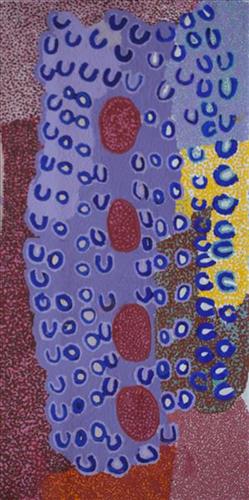
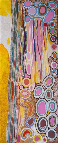
Jarntinti – Mayiwalku May Chapman

“This is a linyji (claypan). We find kalaru (seed used for making damper from samphire bush) there that we collect. Too much good tucker!”  

– Mayiwalku May Chapman

Jarntinti is a large claypan at the Southern end of Nyayartakujarra (Lake Dora), a large salt lake surrounded by tali (sand hills) within the Karlamilyi (Rudall River) region. This area forms part of Mayiwalku’s ngurra (home Country, camp), the region which she traversed extensively as a young girl. Mayiwalku’s sister Nyanjilpayi was born at Jarntinti. 

During the pujiman (traditional, desert dwelling) era, Jarntinti was primarily used as a camping site in the wantajarra (wet season), when the claypan filled with kapi (water). Other nearby water sources include Tarl, Kartuny, Wawul, Warnkarr, Jutupa, and Kunalimpi. 

Jarntinti is known as a site where kalaru grows in abundance. In the pujiman era, the black kalaru seeds were seasonally harvested from this area. Once collected a labour intensive process began to produce damper, a type of flat bread. The kalaru seeds were first washed several times before being ground with a jiwa (stones used by women for grinding seeds) to make a type of flour, which was then mixed with water to create a dough that was finally cooked in the ashes of a fire.

11151030170


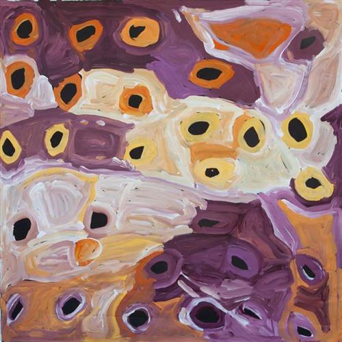
Ngukurrka

This is Kumpaya’s Country- her ‘ngurra’ (home Country, camp). People identify with their ngurra in terms of specific rights and responsibilities, and the possession of intimate knowledge of the physical and cultural properties of one’s Country. Painting ngurra, and in so doing sharing the Jukurrpa (Dreaming) stories and physical characteristics of that place, has today become an important means of cultural maintenance. 

Kumpaya’s ngurra encompasses the Country that she and her family walked in the pujiman (traditional, desert-dwelling) era. At this time she travelled nomadically with her own and other family groups, traversing an enormous tract of land around the middle section of the Canning Stock Route, and between Punmu Aboriginal community and Kiwirrkura, more than 500 kilometres eastward. 

Kumpaya was born close to Kiwirrkurra, a rockhole located in the Gibson Desert and to the south west of Lake McKay. She grew up, walked and hunted primarily around this area. As a young woman Kumpaya travelled westward, through to Kunawarritji (Canning Stock Route Well 33). She continued to live nomadically before eventually deciding to move to Jigalong Mission along with many other relatives following an extreme and prolonged drought in the 1960s. 

Portrayed in this work are features of Kumpaya’s ngurra, such as the striking salt lakes, dominant permanent red tali (sandhills), warta (trees, vegetation), and the individually named water sources she and her family camped at. These include Luurnkurangu, Karingkarra , Katarta, Pinkari, Pintu-pintu, Yanjiwara, Kunalimpi, Juntu-juntu (Canning Stock Route Well 30), Warla-warla (Canning Stock Route Well 31), Kunawarritji, Kinyu (Canning Stock Route Well 35), Natawalu (Canning Stock Route Well 40), and Kupankurlu. Rock holes, waterholes, soaks and springs were all extremely important sites for Martu people during the pujiman period, and are generally depicted with circular forms. 

The encyclopaedic knowledge of the location, quality and seasonal availability of the hundreds of water bodies found in one’s Country sustained Martu as they travelled across their Country, hunting and gathering, visiting family, and fulfilling ceremonial obligations. They would traverse very large distances annually, visiting specific areas in the dry and wet season depending on the availability of water and the corresponding cycles of plant and animal life on which hunting and gathering bush tucker was reliant. As they travelled and hunted they would also burn areas of Country, generating a greater diversity of plant and animal life.
111581414664


Kun Kun (Kuny-Kuny)

“My ngurra (home Country, camp) long, long time ago, Kun Kun! This is a big waterhole. In Kun Kun, my Country, all the animals are coming to drink here. Big and small kangaroos, snakes, goannas, emus, skinks – they all drinking here. Big tali (sandhills). Big ones, four of them near the waterhole.”

– Kumpaya Girgirba (Girgaba)

Kun Kun (Kuny-kuny) is a soak accessing a large body of underground water, located south east of Kunawarritji (Canning Stock Route Well 33). The site is sacred for its association with the marlu (kangaroo) Jukurrpa (Dreaming), and was an important ceremonial site during the pujiman (traditional, desert dwelling) period.

Kun Kun lies within Kumpaya’s ngurra (home Country, camp), the area which she knew intimately and travelled extensively with her family in her youth. The Western Desert term ‘ngurra’ is hugely versatile in application. Broadly denoting birthplace and belonging, ngurra can refer to a body of water, a camp site, a large area of Country, or even a modern house. People identify with their ngurra in terms of specific rights and responsibilities, and the possession of intimate knowledge of the physical and cultural properties of one’s Country. This knowledge is traditionally passed intergenerationally through family connections. Painting ngurra, and in so doing sharing the Jukurrpa stories and physical characteristics of that place, has today become an important means of cultural maintenance. Physical maintenance of one’s ngurra, like cultural maintenance, ensures a site’s wellbeing, and is a responsibility of the people belonging to that area. 

During the pujiman period, knowledge of water sources was critical for survival, and today Martu Country is still defined in terms of the location and type of water. Each of the hundreds of claypans, rockholes, waterholes, soaks and springs found in the Martu desert homelands is known by name, location, quality and seasonal availability through real life experience and the recounting of Jukurrpa narratives. 

111581945515


Untitled

This is Kumpaya’s Country- her ‘ngurra’ (home Country, camp). People identify with their ngurra in terms of specific rights and responsibilities, and the possession of intimate knowledge of the physical and cultural properties of one’s Country. Painting ngurra, and in so doing sharing the Jukurrpa (Dreaming) stories and physical characteristics of that place, has today become an important means of cultural maintenance. 

Kumpaya’s ngurra encompasses the Country that she and her family walked in the pujiman (traditional, desert-dwelling) era. At this time she travelled nomadically with her own and other family groups, traversing an enormous tract of land around the middle section of the Canning Stock Route, and between Punmu Aboriginal community and Kiwirrkura, more than 500 kilometres eastward. 

Kumpaya was born close to Kiwirrkurra, a rockhole located in the Gibson Desert and to the south west of Lake McKay. She grew up, walked and hunted primarily around this area. As a young woman Kumpaya travelled westward, through to Kunawarritji (Canning Stock Route Well 33). She continued to live nomadically before eventually deciding to move to Jigalong Mission along with many other relatives following an extreme and prolonged drought in the 1960s. 

Portrayed in this work are features of Kumpaya’s ngurra, such as the striking salt lakes, dominant permanent red tali (sandhills), warta (trees, vegetation), and the individually named water sources she and her family camped at. These include Luurnkurangu, Karingkarra , Katarta, Pinkari, Pintu-pintu, Yanjiwara, Kunalimpi, Juntu-juntu (Canning Stock Route Well 30), Warla-warla (Canning Stock Route Well 31), Kunawarritji, Kinyu (Canning Stock Route Well 35), Natawalu (Canning Stock Route Well 40), and Kupankurlu. Rock holes, waterholes, soaks and springs were all extremely important sites for Martu people during the pujiman period, and are generally depicted with circular forms. 

The encyclopaedic knowledge of the location, quality and seasonal availability of the hundreds of water bodies found in one’s Country sustained Martu as they travelled across their Country, hunting and gathering, visiting family, and fulfilling ceremonial obligations. They would traverse very large distances annually, visiting specific areas in the dry and wet season depending on the availability of water and the corresponding cycles of plant and animal life on which hunting and gathering bush tucker was reliant. As they travelled and hunted they would also burn areas of Country, generating a greater diversity of plant and animal life.
111576341585


Kulyakartu

“My Country, Kulyakartu. I grew up there, from little boy to big boy grew up there.”

This painting depicts Muuki’s Country, Kulyakartu; an area in the far north of the Martu homelands, near the Percival Lakes in the northern Great Sandy Desert. The artist has extensive knowledge of the Country in this region, where he grew up living traditionally during the pujiman (traditional, desert dwelling) days with his family. Kulyakartu is mostly grass Country where there is very good hunting. There is no permanent water source in Kulyakartu, so his family would walk here annually following the wet season.

Muuki paints his Country in all its different seasonal stages. Often visible in his work is the patchwork of nyurnma (burnt ground) depicting the regrowth subsequent to the practice of waru (fire) burning that assists with hunting, regenerates growth, and encourages greater diversity in plant and animal life.
111581715906


Parnngurr area

Parnngurr is an Aboriginal community located 370km east of Newman, at the Southern end of the Karlimilyi area in the Pilbara region of Western Australia. Created during the Return to Country movement of the 1980s, with the recognition of Aboriginal land rights and native title, the community was named after its original primary water source, a nearby rockhole and yinta (permanent water source). Until recently the community was widely known as Cotton Creek, after the European name for the ephemeral creek running alongside the community. Parngurr and its surrounds are physically dominated by distinctively red tali (sandhills), sparsely covered with spinifex and low lying shrub.

Historically and culturally Parnngurr was an important site for Aboriginal people during the pujiman (traditional, desert-dwelling) era. In the epic jukurrpa (dreamtime) story of the Jakulyukulyu, or Minyipuru (Seven Sisters), the sisters stop to rest on the adjacent Parnngurr hill before continuing on their long journey east. Throughout the pujiman period families stopped and camped here depending on the seasonal availability of water, and the corresponding cycles of plant and animal life on which hunting and gathering bush tucker was reliant. At Parnngurr and other similarly significant camp sites families would meet for a time before moving to their next destination.


111581744219


Waru Waru

“This is the waru-waru, the yukarri warta (green shoots and young plants). After the waru (fire) the mirrka (bush tucker) grows up. After the burning. you get all the animals coming to that place ”

Martu artists paint Country in all it’s different seasonal stages. Important to Martu, and to Martu Country, is the practice of waru (fire burning); a practice that assists with hunting, regenerates growth, and encourages greater diversity in plant and animal life. When Martu Country burns, mosaic fire scars are left on the Country, and patches of regeneration form a kind of mosaic pattern across the land. This is called nyurnma – burnt Country.  Waru is typically burnt in small, controlled areas, leaving a defined patchwork pattern of nyurnma in the land, across tali (sand hills), linyji (clay pans), parulyukurru (spinifex country) and pila (sandy plains). This patterning is clearly visible in Ngamaru’s works, where she paints fire from an aerial perspective.

111581836220


Minyipuru (Seven Sisters)

Minyipuru is an important jukurrpa (dreamtime) story about seven sisters that are travelling through the desert, running away from Yurla, a lustful old man. The man chases the wanti (women) all the way from Roebourne on the west coast, right through Martu country before flying east across Australia. Along the way they stop at many significant sites to camp, sing, dance and collect bush tucker, leaving markers in the landscape along the way. The many events and interactions with Yurla chronicled through the story create a culturally rich narrative that is associated with the Pleiades star constellation.