111581705158


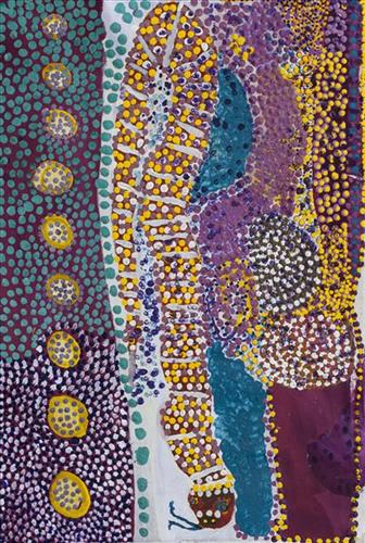
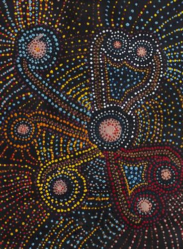
Untitled

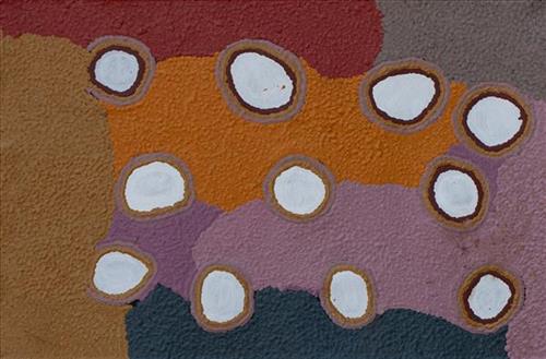
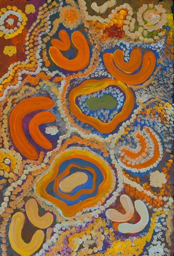
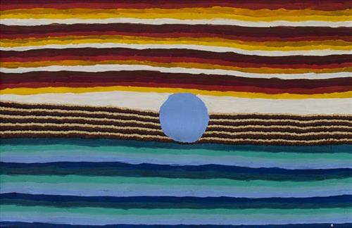
“When Martu paint, it’s like a map. Martu draw story on the ground and on the canvas, and all the circle and line there are the hunting areas and different waters and tracks where people used to walk, and [some you] can’t cross, like boundaries. So nowadays you see a colourful painting and wonder what it is, but that’s how Martu tell story long ago. It’s not just a lovely painting, it’s a story and a songline and a history and everything that goes with it.” 

– Ngalangka Nola Taylor and Joshua Booth

This work portrays an area of Country that can be interpreted in multiple ways. Firstly, the image may be read as an aerial representation of a particular location known to the artist- either land that they or their family travelled, from the pujiman (traditional, desert dwelling) era to now. During the pujiman period, Martu would traverse very large distances annually in small family groups, moving seasonally from water source to water source, and hunting and gathering bush tucker as they went. At this time, one’s survival depended on their intimate knowledge of the location of resources; thus physical elements of Country, such as sources of kapi (water), tali (sandhills), different varieties of warta (trees, vegetation), ngarrini (camps), and jina (tracks) are typically recorded with the use of a use of a system of iconographic forms universally shared across the desert. 

An additional layer of meaning in the work relates to more intangible concepts; life cycles based around kalyu (rain, water) and waru (fire) are also often evident. A thousands of year old practice, fire burning continues to be carried out as both an aid for hunting and a means of land management today. As the Martu travelled and hunted they would burn tracts of land, ensuring plant and animal biodiversity and reducing the risk of unmanageable, spontaneous bush fires. The patchwork nature of regrowth is evident in many landscape works, with each of the five distinctive phases of fire burning visually described with respect to the cycle of burning and regrowth.  

Finally, metaphysical information relating to a location may also be recorded; jukurrpa (dreaming) narratives chronicle the creation of physical landmarks, and can be referenced through depictions of ceremonial sites, songlines, and markers left in the land. Very often, however, information relating to jukurrpa is censored by omission, or alternatively painted over with dotted patterns.

111581705151


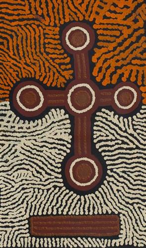
Kumpupirntily

KUMPUPIRNTILY (KUMPUPINTILY, LAKE DISAPPOINTMENT) – YUNKURRA

Ngayurnangalku [were] fighting, coming in from everywhere. They all come in here [at Kumpupirntily], all meet up here. Ngayurnangalku travelled through this Country going to Kumpupirntily. They made that Country. That Country got everything- parngarra (goanna), karlaya (emu), dog, kangaroo, all there. And Ngayurnangalku… they’re there too. 


[Now the] Ngayurnangalku cannibal [live] in a lake, Kumpupirntily. They live in the lake, in the salt lake, that mob. They belong to there. They been born there, they living there, sleeping there. Big mob! That’s his [their] Country, Kumpupirntily. This one the Ngayurnangalku camp, they all there. They got their own city underground. Nobody ever know. Just like a store, you can lock him up. They got a big room, have a rest. Underground, not far. All the man, women, little kids, they all stopping there, and the mummy Ngayurnangalku, big mummy. All those little babies are his [hers]. There’s a hill there. They been walk all along here, they been get inside, that’s their hole over there. They all come and get in there. They got plenty jara (shield), yirrkili (boomerang), they property for the Ngayurnangalku, they maparn (holding power for sorcery). They hit you and kill you. He got to feed. Ngayurnangalku chuck away their jara and yirrkili when they go home. Pujurrpa (red ochre) there – that for Ngayurnangalku, make himself red, when he dance. 


They chuck them [boomerangs] in the afternoon. Before the wind. If it’s a wind blowing, no good, they all go in, in that rock (hill). Parla-parla (type of lizard) is Ngayurnangalku mate. He’s for Kumpupirntily that one. That’s for Ngayurnangalku. When you see that lizard come out, like this (making a smacking sound with its mouth) you gotta get away, you gotta go long way. Don’t come desert. Don’t stop, Ngayurnangalku be get up. Parla-parla make him get up this mob, you gotta go away, run away.”


Ngayurnangalku still there [in Kumpupirntily]. They’re still alive. They walking in the night, they got to feed. They all staying there- don’t go there! You’ll lose your life. We’ll be dead, he’ll be alive. No people gotta go come to this place. If they go there it’s one way! There’s a cannibal there. Don’t come to this place- you might get killed! They gonna eat you for lunch! Don’t go, keep away! I been block him, tell all the miners to keep away. Cannibal gonna come out of the lake, kill you, knock you on the head and have a feed. If they dig him up, anybody, blackfella, whitefella, they’ll get killed! They’ll have a good feed!”


My grandfather went to Lake Disappointment chasing the dingo and he heard an old woman making a noise like howling, but she was crying for that dingo that my grandfather was spearing and chasing. So that woman grabbed his arm and put her long sharp fingernail through his wrist and paralysed him. She put her fingernail right through his wrist. Then that cannibal took him to a group of other cannibals, ready to cook him up to eat. They took him and had him there and they were singing him first. My grandfather is a strong maparn (magic) man. Lucky for him. He got out of there, because of his strength as a maparn.” 


  • Yunkurra Billy Atkins


Yunkurra’s Country encompasses one of the most important and dangerous sites in the Western Desert; Kumpupirntily (Lake Disappointment), home to the Ngayurnangalku (cannibal beings). Kumpupirntily, the Ngayurnangalku, and their associated Jukurrpa (Dreaming) form the subject for the majority of Yunkurra’s copious body of work.


Kumpupirntily is a stark, flat and unforgiving expanse of blinding salt lake surrounded by sand hills, located in the Little Sandy and Gibson Desert of Western Australia; “that Country hasn’t got any trees, it’s just open and flat” (Yunkurra Billy Atkins). Kumpupirntily translates to ‘bladder burst’; the lake was formed when the bladder of the Jila Kujarra (Two Snakes) burst here. Jila Kujarra is one of the key Jukurrpa narratives for the Martu. Though the story belongs to Warnman people, it is shared across the Western Desert with several other language groups. The narrative centres on the travels of two snakes as they are pursued by the Niminjarra, spiritual ancestors of the Warnman people. 


Later in the Jukurrpa period the Ngayurnangalku (ancestral cannibal beings) made Kumpupirntily their home, where they continue to remain today. For this reason Kumpupirntily is considered one of the most sacred and dangerous sites of the Western Desert. The Ngayurnangalku are fearsome ancestral cannibal beings said to resemble people in their appearance, except for their fangs and long curved knife like fingernails they use to catch and hold their human victims. Coming from Natawalu (Canning Stock Route Well 40) in the north, Mundiwinti (Mundawindi) in the west, and from the Country around Kiwirrkurra in the east, the Ngayurnangalku travelled across the desert, stopping near Puntawarri, at Jilukurru (Killagurra Springs, Canning Stock Route Well 17) and at Kupayura (Savory Creek) before finally reaching Kumpupirntily.


At Kumpupirntily, the Ngayurnangalku had a meeting to debate whether or not they would continue to live as cannibals, and eventually came to the decision to stop eating people. That night, a female baby cannibal was born. Following protocol, the baby also had to be consulted by the group. She determined that the Ngayurnangalku should continue to eat people. Her decision divided the group, and from this point the group from the east continued to live as ‘bad’ cannibals at Kumpupirntily, while the group from the west became ‘good’, thereafter consuming only animals. The ‘good’ Ngayurnangalku are kept safe by Nganyangu men, ‘bodyguards’ who formed a sandhill in the middle of the lake. The Nganyangu also help to protect people from the cannibal Ngayurnangalku, providing a safe path of passage through Kumpupirntily. 


The cannibal Ngayurnangalku continue to live beneath the crust of Kumpupirntily lake in an underground world lit by their own sun. They surface only to feed on human flesh, coming in and out of the world we see through a small hill that acts as a gateway between worlds; Yapu Maparnpa (magical hill). Stored with the Ngayurnangalku in their underground world is an arsenal of maparnpa (holding power for sorcery) weapons. Along with these weapons are deposits of pujurrpa that the Ngayurnangalku use to paint themselves with when they dance.


Several phenomena at Kumpupirntily act as a warning of the imminent appearance of the Ngayurnangalku; still skies, wilany (boomerang-shaped clouds), and the emergence of the parla-parla (type of lizard), smacking their mouths. The vigilance of the Martu as they travel in the Country around Kumpupirntily is so great that several other precautions are followed; fires are not lit, planes and helicopters are not flown directly over the area, and digging in the lake is strongly discouraged. All of these activities are believed to disturb the Ngayurnangalku, causing them to rise from their underground world.
111581705148


Untitled

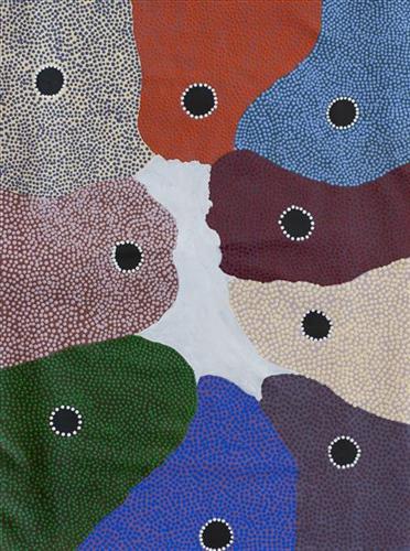
“When Martu paint, it’s like a map. Martu draw story on the ground and on the canvas, and all the circle and line there are the hunting areas and different waters and tracks where people used to walk, and [some you] can’t cross, like boundaries. So nowadays you see a colourful painting and wonder what it is, but that’s how Martu tell story long ago. It’s not just a lovely painting, it’s a story and a songline and a history and everything that goes with it.” 

– Ngalangka Nola Taylor and Joshua Booth

This work portrays an area of Country that can be interpreted in multiple ways. Firstly, the image may be read as an aerial representation of a particular location known to the artist- either land that they or their family travelled, from the pujiman (traditional, desert dwelling) era to now. During the pujiman period, Martu would traverse very large distances annually in small family groups, moving seasonally from water source to water source, and hunting and gathering bush tucker as they went. At this time, one’s survival depended on their intimate knowledge of the location of resources; thus physical elements of Country, such as sources of kapi (water), tali (sandhills), different varieties of warta (trees, vegetation), ngarrini (camps), and jina (tracks) are typically recorded with the use of a use of a system of iconographic forms universally shared across the desert. 

An additional layer of meaning in the work relates to more intangible concepts; life cycles based around kalyu (rain, water) and waru (fire) are also often evident. A thousands of year old practice, fire burning continues to be carried out as both an aid for hunting and a means of land management today. As the Martu travelled and hunted they would burn tracts of land, ensuring plant and animal biodiversity and reducing the risk of unmanageable, spontaneous bush fires. The patchwork nature of regrowth is evident in many landscape works, with each of the five distinctive phases of fire burning visually described with respect to the cycle of burning and regrowth.  

Finally, metaphysical information relating to a location may also be recorded; jukurrpa (dreaming) narratives chronicle the creation of physical landmarks, and can be referenced through depictions of ceremonial sites, songlines, and markers left in the land. Very often, however, information relating to jukurrpa is censored by omission, or alternatively painted over with dotted patterns.

111581705136


Untitled

“When Martu paint, it’s like a map. Martu draw story on the ground and on the canvas, and all the circle and line there are the hunting areas and different waters and tracks where people used to walk, and [some you] can’t cross, like boundaries. So nowadays you see a colourful painting and wonder what it is, but that’s how Martu tell story long ago. It’s not just a lovely painting, it’s a story and a songline and a history and everything that goes with it.” 

– Ngalangka Nola Taylor and Joshua Booth

This work portrays an area of Country that can be interpreted in multiple ways. Firstly, the image may be read as an aerial representation of a particular location known to the artist- either land that they or their family travelled, from the pujiman (traditional, desert dwelling) era to now. During the pujiman period, Martu would traverse very large distances annually in small family groups, moving seasonally from water source to water source, and hunting and gathering bush tucker as they went. At this time, one’s survival depended on their intimate knowledge of the location of resources; thus physical elements of Country, such as sources of kapi (water), tali (sandhills), different varieties of warta (trees, vegetation), ngarrini (camps), and jina (tracks) are typically recorded with the use of a use of a system of iconographic forms universally shared across the desert. 

An additional layer of meaning in the work relates to more intangible concepts; life cycles based around kalyu (rain, water) and waru (fire) are also often evident. A thousands of year old practice, fire burning continues to be carried out as both an aid for hunting and a means of land management today. As the Martu travelled and hunted they would burn tracts of land, ensuring plant and animal biodiversity and reducing the risk of unmanageable, spontaneous bush fires. The patchwork nature of regrowth is evident in many landscape works, with each of the five distinctive phases of fire burning visually described with respect to the cycle of burning and regrowth.  

Finally, metaphysical information relating to a location may also be recorded; jukurrpa (dreaming) narratives chronicle the creation of physical landmarks, and can be referenced through depictions of ceremonial sites, songlines, and markers left in the land. Very often, however, information relating to jukurrpa is censored by omission, or alternatively painted over with dotted patterns.

111581706029


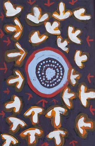
Emu Tracks to Puntawarri

“Emu go to the springs to have a drink of water and then move on to the next one.”

– Judith Anya Samson

Puntawarri is an important cultural area, as well as the site of a now abandoned community, a waterhole, creek and lake. Puntawarri is located on the middle stretches of the Canning Stock Route and east of the Jigalong Aboriginal Community, where Judith grew up with her grandmother and senior Martumili Artist Dadda Samson. Both artists continue to live there today.

Puntawarri lies within Judith’s ngurra (home Country, camp) through her mother’s family, and as a young girl she frequently travelled and hunted with her family in this area, learning the stories for this Country. Depicted in this work are the tracks of a group of emus on their way to Puntawarri waterhole, searching for kapi (water). 

Karlaya (emu) were traditionally hunted during the pujiman (traditional, desert dwelling) era, and they continue to be a favoured bush tucker for Martu today. During the pujiman (traditional, desert dwelling) period, Martu would traverse very large distances annually in small family groups, moving seasonally from water source to water source, and hunting and gathering bush tucker as they went. Jina (tracks, footprints) are used by Martu people when tracking bush tucker. In the absence of an actual animal sighting, tracks act as an identifier that an animal was present, which can then be followed to the animal’s present location. Besides providing information on location, Martu are able to interpret from tracks the passage of time since the tracks were imprinted, as well as the corresponding animal species and its size.

The softer and more extensive the ground surface, the easier it is to locate and follow tracks, thus certain conditions are favoured for tracking. Tuulparra (spring) and yalijarra (hot time) are preferred over wantajarra (winter), when south easterly tradewinds blow strongly to obscure tracks. Tracks and burrows are also more readily visible in early growth lands, such as nyurnma (freshly burnt Country) and waru-waru (growth of new shoots and young plants). For this reason, fire burning is an important tool in animal tracking. Small burns are lit to clear vegetation, expose burrows, and to allow for access to walk and track readily in exposed sands, while simultaneously providing diverse regenerating habitats.

111981709558


Wak Wak

This painting depicts a sacred site at ‘Kurrurldul’, an outstation south of Maningrida.

The ‘rarrk’, or abstract crosshatching, on this work represents the design for the crow totem ancestor called ‘Djimarr’. Today this being exists in the form of a rock, which is permanently submerged at the bottom of Kurrurldul Creek. The ‘Djimarr’ rock in the stream at Kurrurldul is said to move around and call out in a soft hooting tone at night. Both the stone itself and the area around it are considered sacred.

The imagery represents the rock mentioned above at the bottom of Kurrurldul creek, which is the final transmutation of the dreaming ancestor ‘Djimarr’. Finally, the pattern used here is also the crow design used in the sacred ‘Mardayin’ ceremony, which is a large regional patri-moiety ceremony now rarely conducted in central and eastern Arnhem Land.

111581709845


Wantili

“This is Wantili, this is my Country, Amy’s Country, everybody’s Country. . It’s the hill and all the kapi (water). This one big Country, big area, pubajba (hills) claypan- big one. Water been running, rolling, rolling from these hill here. Trees and spinifex all the marba (bush tucker) Amy was born here. All palya (good).”

– Lily Jatarr Long

Wantili is a large lyinji (clay pan) near Well 24 on the Canning Stock Route. The area is dominated by claypans surrounded by tuwa (sandhills), and following rain the claypans are filled with water. At that time the site becomes an important place for obtaining fresh water for drinking and bathing. Wantili is significant for the fact that at this site Kartujarra, Manyjilyjarra, Putujarra and Warnman people would all come together for ceremonies. Many jiwa (stones used by women for grinding seeds) from these times can still be found there today.


111581709834


Untitled

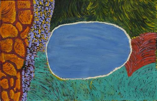
This painting represents the “Rock hole’ Jurnu, Yinta, everything!!”

When the artist was younger during the Pujiman (bush) days she walked around a very extensive area of the desert all around the Canning Stock Route area. They would walk from water source to water source; this is what she is illustrating through this painting. Represented are a lot of the different Jurnu (rock holes) and Yinta (spring) where she and her family would go.

Mili means belongs to everybody and Ngurra is home or country, all of the artists family walked here. She was here with all her Jurtu (sisters) Wungu, Yarpa, Nyikaya and Wunja walking around everywhere. She was also in this country with fellow artists Nora Wompi and Nora Nungabar as well as her mummy Yurnurr.

When the artist was a baby in the Pujiman time near Kilkil (well 36) on the Canning Stock Route there was no whitefellas. Then they saw the drovers with the bullocks and camels so they ran away a long way. She didn’t like them and she had no clothes on.


111581709815


Punmu lake

Punmu is an Aboriginal community located 670km North-East of Newman, in the Pilbara region of Western Australia. Created during the return to Country movement of the 1980s, with the recognition of Martu land rights and native title, the community was named after a nearby jukurrpa (dreamtime) story.

Punmu community sits on the edge of a large salt lake known as Nyayartakujarra, or Lake Dora. The lake runs south into Karlamilyi River. There are many yinta (permanent water sources) in Punmu’s nearby vicinity including Wilarra, Rawa, Yilyara, Jilajila and Tuutuu.

Punmu features in several jukurrpa narratives. Of particular importance for the Warnman people is the story of the ‘Jila Kujarra’ (Two Snakes). These snakes travelled through Parnngurr, Punkulyi, Yulpu, and Winukurrujunu, forming lakes, claypans, rocks, rockholes, waterholes and soaks as they went. The powerful elder of the two snakes, Wirnpa, finally stopped at the site of Wirnpa, named for him. The young snake kept on travelling until coming to Punmu waterholes Rawa and Yilyarra, making that Country his ngurra (home camp). Another jukurrpa story describes the formation of Nyayartakujarra as occurring when two travelling snakes were first sung to sleep and then killed by magic men. The snakes’ fat was said to have burned away and melted into Nyayartakujarra.

111581711273


Untitled

“When Martu paint, it’s like a map. Martu draw story on the ground and on the canvas, and all the circle and line there are the hunting areas and different waters and tracks where people used to walk, and [some you] can’t cross, like boundaries. So nowadays you see a colourful painting and wonder what it is, but that’s how Martu tell story long ago. It’s not just a lovely painting, it’s a story and a songline and a history and everything that goes with it.” 

– Ngalangka Nola Taylor and Joshua Booth

This work portrays an area of Country that can be interpreted in multiple ways. Firstly, the image may be read as an aerial representation of a particular location known to the artist- either land that they or their family travelled, from the pujiman (traditional, desert dwelling) era to now. During the pujiman period, Martu would traverse very large distances annually in small family groups, moving seasonally from water source to water source, and hunting and gathering bush tucker as they went. At this time, one’s survival depended on their intimate knowledge of the location of resources; thus physical elements of Country, such as sources of kapi (water), tali (sandhills), different varieties of warta (trees, vegetation), ngarrini (camps), and jina (tracks) are typically recorded with the use of a use of a system of iconographic forms universally shared across the desert. 

An additional layer of meaning in the work relates to more intangible concepts; life cycles based around kalyu (rain, water) and waru (fire) are also often evident. A thousands of year old practice, fire burning continues to be carried out as both an aid for hunting and a means of land management today. As the Martu travelled and hunted they would burn tracts of land, ensuring plant and animal biodiversity and reducing the risk of unmanageable, spontaneous bush fires. The patchwork nature of regrowth is evident in many landscape works, with each of the five distinctive phases of fire burning visually described with respect to the cycle of burning and regrowth.  

Finally, metaphysical information relating to a location may also be recorded; jukurrpa (dreaming) narratives chronicle the creation of physical landmarks, and can be referenced through depictions of ceremonial sites, songlines, and markers left in the land. Very often, however, information relating to jukurrpa is censored by omission, or alternatively painted over with dotted patterns.